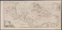
Cross Collection no., From The political magazine (March 1780), v. 1, opposite p. 179., Includes inset map: The Harbour & Fort of Omoa., Mounted on linen., and Scales in British statute miles (69 to a degree) and British marine leagues.
Publisher:
s.n.,
Subject (Geographic):
Caribbean Area--Maps--Early works to 1800, Central America--Maps--Early works to 1800, and Omoa (Cortés, Honduras)--Maps--Early works to 1800
Subject (Topic):
Harbors--Honduras--Omoa--Maps--Early works to 1800
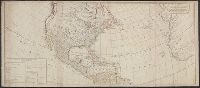
Includes table of "The continent and islands of America are divided and possessed as follows viz." and May be part of a map attributed to R. Sayer, based on maps by d'Anville and materials by Thomas Pownall; first issued in 1763 by J. Gibson and reissued over
Publisher:
s.n.,
Subject (Geographic):
America--Maps--Early works to 1800 and North America--Maps--Early works to 1800
Subject (Name):
Anville, Jean Baptiste Bourguignon d', 1697-1782, Gibson, J. (John), and Pownall, Thomas, 1722-1805
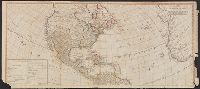
Includes table of "The continent and islands of America are divided and possessed as follows viz.", Prime meridian: Ferro., and Probably part of a map attributed to R. Sayer, based on maps by d'Anville and materials by Thomas Pownall; first issued in 1763 by J.
Publisher:
s.n.,
Subject (Geographic):
America--Maps--Early works to 1800 and North America--Maps--Early works to 1800
Subject (Name):
Anville, Jean Baptiste Bourguignon d', 1697-1782, Gibson, J. (John), and Pownall, Thomas, 1722-1805
In upper right corner: Gent. Mag., Prime meridian: London., Relief shown pictorially and with hachures., Removed from: Gentleman's magazine. [June 1763]., Sheet measures 20.4 x 26.9 cm. Cross Collection no. 186., and Shows locations of North American Indian tribes.
Publisher:
Gentleman's Magazine,
Subject (Geographic):
Mississippi River Valley--Maps--Early works to 1800 and North America--Maps--Early works to 1800
Subject (Topic):
Indians of North America--Maps--Early works to 1800
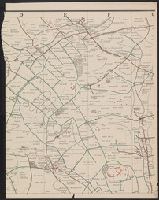
"Situation map" stamped in lower right corner., Red lines indicate fluctuating location of the Western Front, with dates of "March 21" through "March 31", year unspecified., and Shows Amiens to the west and St. Quentin to the east.