Skip to search
Skip to main content
Skip to first result
Search
You Searched For
Format
cartographic
Publication Place
Paris :
New Search
Search Results
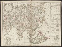
Published / Created:
1791
Call Number:
50 1791
Container / Volume:
BRBL_00272
Image Count:
1
Resource Type:
Maps, Atlases & Globes
Publisher:
Delamarche,
Subject (Geographic):
Asia--Maps--Early works to 1800
Found in:
Beinecke Rare Book and Manuscript Library > Asie divisée ... Etats, Empires, & Royaumes Par Robert de Vaugondy ...
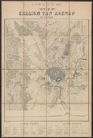
Creator:
Published / Created:
[1870]
Call Number:
48 AT42 1863
Container / Volume:
BRBL_00264
Image Count:
1
Resource Type:
Maps, Atlases & Globes
Description:
In French and Greek., Indices on verso., Profile below neat line: Τομὴ κατα α β., Relief shown by hachures., and Title panel on verso.
Publisher:
Imp. Lemercier,
Subject (Geographic):
Athens (Greece)--Maps
Subject (Name):
Erhard (Firm) and Imprimerie Lemercier et cie
Found in:
Beinecke Rare Book and Manuscript Library > Athènes et ses environs [cartographic material] / exécuté par Emmanuel Kalergis, Élève de St. Cyr et de L'École Impériale d'État-Major de France ; gravé chez Erhard.
Creator:
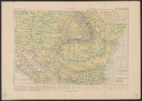
Published / Created:
[1894 or 1895]
Call Number:
53 1894
Container / Volume:
BRBL_00285
Image Count:
2
Resource Type:
Maps, Atlases & Globes
Alternative Title:
Atlas Vidal Lablanche, États danubiens, and Vient de paraîrte
Description:
Prospectus for the Atlas général Vidal-Lablache; Includes sample map from the Atlas: États danubiens, p. 97a-97b.
Publisher:
Armand Colin & cie,
Subject (Geographic):
Balkan Peninsula--Maps
Subject (Name):
Vidal de La Blache, Paul, 1845-1918
Found in:
Beinecke Rare Book and Manuscript Library > Atlas général Vidal-Lablache, historique et géographique / par M. P. Vidal de la Blache, sous-directeur et maître de conférences à l'École normale supérieure. 420 cartes et cartons en couleur, Index alphabetique de 46,000 mots.
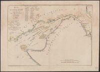
Published / Created:
1777
Call Number:
775cea 1777
Container / Volume:
BRBL_00502
Image Count:
2
Resource Type:
Maps, Atlases & Globes
Publisher:
Le Rouge,
Subject (Geographic):
Delaware Bay (Del. and N.J.)--Maps--Early works to 1800
Found in:
Beinecke Rare Book and Manuscript Library > BAye de la Delaware avec les ports, sondes, dangers, bancs, &c, depuis les caps jusqu'a Philadelphie, d'apres la carte de Joshua Fisher publiee a Philadelphie.
Published / Created:
1919
Call Number:
11hcf 1919C-9
Container / Volume:
BRBL_00010V
Image Count:
5
Resource Type:
Maps, Atlases & Globes
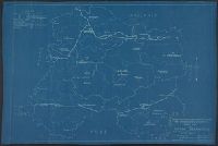
Description:
In bottom right: Drawn by R.A.K., Checked by W.H.J. ; No. 343-A-5. and Shows department, arrondissement and canton seats and boundaries, battle lines.
Publisher:
The Commission,
Subject (Geographic):
Marne (France)--Maps
Found in:
Beinecke Rare Book and Manuscript Library > Base Map of Marne Department : Taken from File 74-A-3 / American Commision to Negotiate Peace, War Damages in Allied Countries.
Published / Created:
1919
Call Number:
11hcf 1919C-10
Container / Volume:
BRBL_00010S
Image Count:
6
Resource Type:
Maps, Atlases & Globes
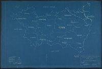
Description:
In bottom right: Drawn by Hansen, Checked by Jones ; No. 347-A-5. and Shows department, arrondissement and canton seats and boundaries, Battle lines of Sept. 6, 1914; March 20, 1918; and Nov. 11, 1918.
Publisher:
The Commission,
Subject (Geographic):
Meuse (France)--Maps
Found in:
Beinecke Rare Book and Manuscript Library > Base Map of Meuse Department : Taken from File 74-A-3 / American Commision to Negotiate Peace, War Damages in Allied Countries.
Published / Created:
1919
Call Number:
11hcf 1919C-8
Container / Volume:
BRBL_00010V
Image Count:
6
Resource Type:
Maps, Atlases & Globes
Description:
In bottom right: Drawn by S.R., Checked by W.H.J. ; No. 344-A-5. and Shows department, arrondissement and canton seats and boundaries, battle lines.
Publisher:
The Commission,
Subject (Geographic):
Marne (France)--Maps and Seine (France)--Maps
Found in:
Beinecke Rare Book and Manuscript Library > Base Map of Seine et Marne Department: Taken from File No. 115-G-1 / American Commision to Negotiate Peace, War Damages in Allied Countries.
Published / Created:
1919
Call Number:
11hcf 1919C-7
Container / Volume:
BRBL_00010V
Image Count:
6
Resource Type:
Maps, Atlases & Globes
Description:
In bottom right: No. 345-A-5. and Shows department, arrondissement and canton seats and boundaries, national boundaries, battle lines.
Publisher:
The Commission,
Subject (Geographic):
Somme (France)--Maps
Found in:
Beinecke Rare Book and Manuscript Library > Base Map of Somme Department: Taken from File No. 74-A-3 / American Commision to Negotiate Peace, War Damages in Allied Countries.
Published / Created:
1919
Call Number:
11hcf 1919C-11
Image Count:
8
Resource Type:
Maps, Atlases & Globes
Description:
In bottom right: Drawn by S.R., Checked by W.H.J. ; No. 278-A-5. and Shows department, arrondissement and canton seats, national boundaries, battle lines.
Publisher:
The Commission,
Subject (Geographic):
Vosges (France)--Maps
Found in:
Beinecke Rare Book and Manuscript Library > Base Map of Vosges Department: Taken from File No. 74-A-3 / American Commision to Negotiate Peace, War Damages in Allied Countries.
Published / Created:
191-.
Call Number:
11hcf 1919D-29
Container / Volume:
BRBL_00010X
Image Count:
1
Resource Type:
Maps, Atlases & Globes
Description:
Includes table of major cities, distances between those cities, and 2 inset maps. and Shows distances and population.
Publisher:
The Scarborough Co.,
Subject (Geographic):
Belgium--Maps
Found in:
Beinecke Rare Book and Manuscript Library > Belgique : Carte Administrative et Commerciale; chemins de fer, canaux, routes / publiée par "The Scarborough Co.", Éditeurs de Cartes Géographiques.
Branch:v1.64.0 ,Deployed:2024-09-11T10:25:15-04:00