Search
You Searched For
Search Results
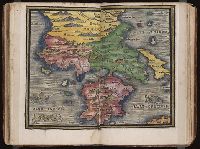
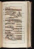
- Published / Created:
- [1542]
- Call Number:
- Taylor 86
- Collection Title:
- Rvdimenta cosmographica
- Image Count:
- 1
- Subject (Geographic):
- Balkan Peninsula and Greece
- Subject (Topic):
- Cosmography, Early maps, and Geography, Medieval
- Collection Created:
- Impressvm in inclyta Transylvaniae Corona 1542
- Found in:
- Beinecke Rare Book and Manuscript Library > [Map of the Balkan Peninsula including Macedonia and Greece]
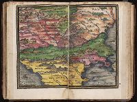
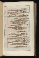
- Published / Created:
- [1542]
- Call Number:
- Taylor 86
- Collection Title:
- Rvdimenta cosmographica
- Image Count:
- 1
- Subject (Geographic):
- Balkan Peninsula
- Subject (Topic):
- Cosmography, Early maps, and Geography, Medieval
- Collection Created:
- Impressvm in inclyta Transylvaniae Corona 1542
- Found in:
- Beinecke Rare Book and Manuscript Library > [Map of the Balkan Peninsula including Macedonia, Blugaria, Moldova]
- Published / Created:
- 1802
- Call Number:
- Im B388 Zz802B
- Collection Title:
- The imperial guide : with picturesque plans of the great post roads, containing miniatures
- Image Count:
- 1
- Description:
- Bound in between p. 24-25. and William Beckford’s copy, with his penciled annotations. Autograph of William Beckford.
- Subject (Geographic):
- England --Guidebooks, England --Maps, Great Britain --Description and travel --Views, and Great Britain --Road maps
- Subject (Topic):
- Roads --Great Britain
- Collection Created:
- London : Printed by C. Whittingham, Dean Street, Fetter Lane, and sold by H.D. Symonds, Paternoster-Row; [etc], 1802
- Found in:
- Beinecke Rare Book and Manuscript Library > [Map: Carlisle to Bolton]
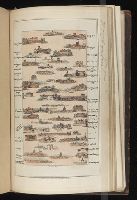
- Published / Created:
- 1802
- Call Number:
- Im B388 Zz802B
- Collection Title:
- The imperial guide : with picturesque plans of the great post roads, containing miniatures
- Image Count:
- 1
- Description:
- Bound in between p. 4-5. and William Beckford’s copy, with his penciled annotations. Autograph of William Beckford.
- Subject (Geographic):
- England --Guidebooks, England --Maps, Great Britain --Description and travel --Views, and Great Britain --Road maps
- Subject (Topic):
- Roads --Great Britain
- Collection Created:
- London : Printed by C. Whittingham, Dean Street, Fetter Lane, and sold by H.D. Symonds, Paternoster-Row; [etc], 1802
- Found in:
- Beinecke Rare Book and Manuscript Library > [Map: Coventry to Stony Stratford]
- Published / Created:
- 1802
- Call Number:
- Im B388 Zz802B
- Collection Title:
- The imperial guide : with picturesque plans of the great post roads, containing miniatures
- Image Count:
- 1
- Description:
- Bound in between p. 38-39. and William Beckford’s copy, with his penciled annotations. Autograph of William Beckford.
- Subject (Geographic):
- England --Guidebooks, England --Maps, Great Britain --Description and travel --Views, and Great Britain --Road maps
- Subject (Topic):
- Roads --Great Britain
- Collection Created:
- London : Printed by C. Whittingham, Dean Street, Fetter Lane, and sold by H.D. Symonds, Paternoster-Row; [etc], 1802
- Found in:
- Beinecke Rare Book and Manuscript Library > [Map: Islip to Paddington]
- Published / Created:
- 1802
- Call Number:
- Im B388 Zz802B
- Collection Title:
- The imperial guide : with picturesque plans of the great post roads, containing miniatures
- Image Count:
- 1
- Description:
- Bound in between p. 22-23. and William Beckford’s copy, with his penciled annotations. Autograph of William Beckford.
- Subject (Geographic):
- England --Guidebooks, England --Maps, Great Britain --Description and travel --Views, and Great Britain --Road maps
- Subject (Topic):
- Roads --Great Britain
- Collection Created:
- London : Printed by C. Whittingham, Dean Street, Fetter Lane, and sold by H.D. Symonds, Paternoster-Row; [etc], 1802
- Found in:
- Beinecke Rare Book and Manuscript Library > [Map: Lancaster to Worsley]
- Published / Created:
- 1802
- Call Number:
- Im B388 Zz802B
- Collection Title:
- The imperial guide : with picturesque plans of the great post roads, containing miniatures
- Image Count:
- 1
- Description:
- Bound in between p. 6-7. and William Beckford’s copy, with his penciled annotations. Autograph of William Beckford.
- Subject (Geographic):
- England --Guidebooks, England --Maps, Great Britain --Description and travel --Views, and Great Britain --Road maps
- Subject (Topic):
- Roads --Great Britain
- Collection Created:
- London : Printed by C. Whittingham, Dean Street, Fetter Lane, and sold by H.D. Symonds, Paternoster-Row; [etc], 1802
- Found in:
- Beinecke Rare Book and Manuscript Library > [Map: Stafford to Coventry]
- Published / Created:
- 1802
- Call Number:
- Im B388 Zz802B
- Collection Title:
- The imperial guide : with picturesque plans of the great post roads, containing miniatures
- Image Count:
- 1
- Description:
- Bound in between p. 10-11. and William Beckford’s copy, with his penciled annotations. Autograph of William Beckford.
- Subject (Geographic):
- England --Guidebooks, England --Maps, Great Britain --Description and travel --Views, and Great Britain --Road maps
- Subject (Topic):
- Roads --Great Britain
- Collection Created:
- London : Printed by C. Whittingham, Dean Street, Fetter Lane, and sold by H.D. Symonds, Paternoster-Row; [etc], 1802
- Found in:
- Beinecke Rare Book and Manuscript Library > [Map: Talk on the Hill to Birmingham]
- Creator:
- Colorado Midland Railway Company
- Published / Created:
- undated
- Call Number:
- WA MSS S-1741 BrSides
- Collection Title:
- Colorado Midland Railway Company maps
- Container / Volume:
- Folder 9
- Image Count:
- 22
- Resource Type:
- Maps, Atlases & Globes
- Description:
- Folder also contain 2 MS notes in pencil, 21 cm. and smaller. and Versos blank, not digitized.
- Subject (Geographic):
- Aspen (Colo.)--Maps, Colorado--Maps, Garfield County (Colo.)--Maps, and Pitkin County (Colo.)--Maps
- Subject (Name):
- Colorado Midland Railway Company
- Subject (Topic):
- Mines and mineral resources--Colorado--Maps and Railroads--Colorado--Maps
- Found in:
- Beinecke Rare Book and Manuscript Library > [Maps of Aspen Branch, Jerome Park Branch, Pitkin-Garfield Counties, Colorado]
- Creator:
- Colorado Midland Railway Company
- Published / Created:
- undated
- Call Number:
- WA MSS S-1741 BrSides
- Collection Title:
- Colorado Midland Railway Company maps
- Container / Volume:
- Folder 2
- Image Count:
- 10
- Resource Type:
- Maps, Atlases & Globes
- Description:
- Folder includes indes of maps on ledger paper, 44 x 56 cm. and Versos blank, not digitized.
- Subject (Geographic):
- Colorado--Maps, Garfield County (Colo.)--Maps, and Glenwood Springs (Colo.)--Maps
- Subject (Name):
- Colorado Midland Railway Company
- Subject (Topic):
- Mines and mineral resources--Colorado--Maps and Railroads--Colorado--Maps
- Found in:
- Beinecke Rare Book and Manuscript Library > [Maps of Garfield County, Colorado]