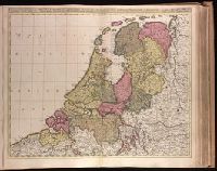
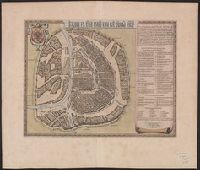
Appears in Valk and Schenk's Atlantis sylloge compendiosa, ca. 1702., Backed with paper. Ms. no. "40" in upper-right corner. Sheet measures 53.6 x 63.0 cm. No. 39 of 87 maps bound together., Bar scales given in "horae itinerissive milliaria Gallica" and "milliaria Germanica"., Prime meridian: Ferro., and Watermark.
Publisher:
Gerard Valk,
Subject (Geographic):
Netherlands--Maps--Early works to 1800.
Subject (Name):
Schenk, Peter, 1660-1718 or 1719. Atlantis sylloge compendiosa., Valck, G. (Gerard), 1651 or 1652-1726. Atlantis sylloge compendiosa., and Valck, Leonard, 1675-1746.
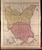
Appeared in Valk and Schenk's Atlantis sylloge compendiosa, ca. 1702., Backed with paper. Ms. no. "82" in upper left corner. Sheet measures 62.5 x 53.7 cm. No. 76 of 87 maps bound together., Bar scales given in "milliaria Hungarica" and "milliaria Germanica.", Prime meridian: Ferro., and Relief shown pictorially.
Publisher:
Gerard Valk,
Subject (Geographic):
Bulgaria--Maps--Early works to 1800., Romania--Maps--Early works to 1800., and Turkey--Maps--Early works to 1800.
Subject (Name):
Schenk, Peter, 1660-1718 or 1719. Atlantis sylloge compendiosa. and Valck, G. (Gerard), 1651 or 1652-1726. Atlantis sylloge compendiosa.
Appears in Blaeu's Atlas major, Fre, Hand col. Sheet measures 54 x 63 cm. Lanman Collection., Russian, Latin and French., Title text in cyrillic; transliteration in Koeman., and Verso: Title "Moskow, ville metropolitaine de Moscovie"; pg. no. 20,b; signature F 2.
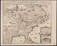
Appears in Chatelain's Atlas historique according to McCorkle., Cross collection no. 149., In upper right: Tom: VI. No: 23. Pag: 91., Includes notes, table of coordinates for certain locations, and ill., and Insets: Les environs de Quebec -- Veüe de Quebec -- Les costes de la Louisiane.
Publisher:
Chez L'Honoré & Châtelain Libraires?,
Subject (Geographic):
New France--Maps--Early works to 1800 and North America--Maps--Early works to 1800
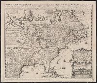
Appears in Chatelain's Atlas historique according to McCorkle., Cross collection no. 149., In upper right: Tom: VI. No: 23. Pag: 91., Includes notes, table of coordinates for certain locations, and ill., McCorkle attributes authorshi, and Relief shown pictorially.
Publisher:
Chez L'Honoré & Châtelain Libraires?,
Subject (Geographic):
New France--Maps--Early works to 1800 and North America--Maps--Early works to 1800
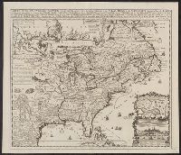
Appears in Chatelain's Atlas historique according to McC, In upper right: Tom: VI. No: 23. Pag: 91., Includes notes, table of coordinates for certain locations, and ill., McCorkle attributes authorship of this map to Nicolas de Fer., and Relief shown pictorially.
Publisher:
Chez L'Honoré & Châtelain Libraires?,
Subject (Geographic):
New France--Maps--Early works to 1800 and North America--Maps--Early works to 1800
Based on Guillaume de L'Isle's Carte du Canada ... 1703., From Chatelain's Atlas historique ... Amsterdam : Chez L'Honoré & Châtelain, 1718-21., In upper right corner: Tom: VI. No: 20. Pag: 82., Includes text., Reli, and Sheet measures 45.3 x 57.1 cm.
Publisher:
Chez l'Honore & Chatelain Libraires,
Subject (Geographic):
Canada--Maps--Early works to 1800 and New France--Maps--Early works to 1800