Skip to search
Skip to main content
Skip to first result
Search
You Searched For
Format
cartographic
Publication Place
Boston :
New Search
Search Results
Published / Created:
1843
Call Number:
764 B65 1843
Container / Volume:
BRBL_00455
Image Count:
1
Resource Type:
Maps, Atlases & Globes
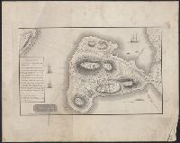
Description:
Inset with "References" to sketch.
Publisher:
Published by Geo. G. Smith, engraver,
Subject (Geographic):
Boston (Mass.)--Maps
Found in:
Beinecke Rare Book and Manuscript Library > Sketch of the Battle of Bunker Hill by a British Officer.
Creator:
Published / Created:
c1899.
Call Number:
642 1899B
Container / Volume:
BRBL_00339
Image Count:
1
Resource Type:
Maps, Atlases & Globes
Publisher:
The Company,
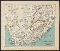
Subject (Geographic):
South Africa--Maps
Found in:
Beinecke Rare Book and Manuscript Library > South Africa [cartographic material].
Published / Created:
1909
Call Number:
763gmb 1909
Container / Volume:
BRBL_00452
Image Count:
1
Resource Type:
Maps, Atlases & Globes
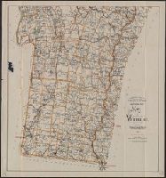
Alternative Title:
Map of Vermont, Southern Part
Description:
"Copyright 1896, 1902 & 1908 by Geo. Wal, Shows town boundaries; town post office locations; some pond, lake, stream, and mountain names; some road names; and Central Vermont Railroad line., and Stamped "American Map Co. Distributors, 7 West 42nd St. New York".
Publisher:
Walker Lithograph & Pub. Co. ,
Subject (Geographic):
Vermont--Maps
Found in:
Beinecke Rare Book and Manuscript Library > Southern Part, Map of Vermont.
Published / Created:
1835
Call Number:
764 B65 1835
Container / Volume:
BRBL_00455
Image Count:
1
Resource Type:
Maps, Atlases & Globes
Description:
"The plan is to have a rail road track reach every door, in every street of this territory, to the edge of the ocean on one side, and to the heart of the country on the other." and Includes text.
Publisher:
Pendleton's Lithography,
Subject (Geographic):
Boston (Mass.)--Maps
Subject (Name):
Pendleton's Lithography
Subject (Topic):
City planning--Massachusetts--Boston--Maps
Found in:
Beinecke Rare Book and Manuscript Library > The South Cove territory, comprising every part which is coloured on this map.
Published / Created:
1850
Call Number:
11 1850
Container / Volume:
BRBL_00009
Image Count:
1
Resource Type:
Maps, Atlases & Globes
Description:
Insets: The Nicaraguan Route, The Proposed Rail Road from St. Louis to the Bay of San Francisco. and Preliminary record.
Publisher:
J. Haven,
Subject (Geographic):
World--maps
Found in:
Beinecke Rare Book and Manuscript Library > The World on Mercator's Projection: By David H. Burr. Showing the different routes to California and distance by each. Routes of different Navigators, route of the contemplated Pacific R.Road. Distances to China, Europe, etc.
Creator:
Published / Created:
1877
Call Number:
766am H26 1877
Container / Volume:
BRBL_00474
Image Count:
1
Resource Type:
Maps, Atlases & Globes
Description:
"Entered according to Act of Congress ... by O. H. Bailey & J. L. Galt, in the office of the Librarian of Congress.", Bird's-eye-view., and Includes index to points of interest and illus.
Publisher:
O.H. Bailey & Co.,
Subject (Geographic):
Hartford (Conn.)--Aerial views
Subject (Name):
Bailey, O. H. (Oakley Hoopes), 1843-1947 and Galt, J. L
Found in:
Beinecke Rare Book and Manuscript Library > The city of Hartford, Connecticut. By O.H. Bailey & Co.
Published / Created:
1879
Call Number:
766am N46 1879V
Container / Volume:
BRBL_00474
Image Count:
1
Resource Type:
Maps, Atlases & Globes
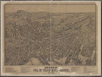
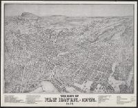
Description:
A view of New Haven., Has list of 51 important places., Indexed., and Shows buildings, trees, houses, streets, names of streets, etc.
Publisher:
O.H. Bailey & J.C. Hazen,
Subject (Geographic):
New Haven (Conn.)--Maps
Found in:
Beinecke Rare Book and Manuscript Library > The city of New Haven, Conn.
Published / Created:
1879
Call Number:
766am N46 1879V
Container / Volume:
BRBL_00474
Image Count:
1
Resource Type:
Maps, Atlases & Globes
Description:
A view of New Haven., Has list of 51 important places., Indexed., and Shows buildings, trees, houses, streets, names of streets, etc.
Publisher:
O.H. Bailey & J.C. Hazen,
Subject (Geographic):
New Haven (Conn.)--Maps
Found in:
Beinecke Rare Book and Manuscript Library > The city of New Haven, Conn.
Published / Created:
1893
Call Number:
766 T57 1893
Container / Volume:
BRBL_00474
Image Count:
1
Resource Type:
Maps, Atlases & Globes
Publisher:
Geo. H. Walker & Co. ,
Subject (Geographic):
Tolland (Conn.)--Maps
Found in:
Beinecke Rare Book and Manuscript Library > Tolland [County].
Creator:
Published / Created:
[1890?].
Call Number:
753gme 1890
Container / Volume:
BRBL_00415
Image Count:
1
Resource Type:
Maps, Atlases & Globes
Description:
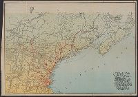
Color illus. across head of map. and RaIlroad lines indicated in red.
Publisher:
Rand Avery Supply Co. ,
Subject (Geographic):
Northeastern States--Maps
Found in:
Beinecke Rare Book and Manuscript Library > Tourist map of the Boston and Maine Railroad.
Branch:v1.61.8 ,Deployed:2024-06-20T11:14:55-04:00