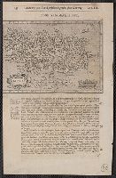
Chap. 22, Discipline, honour, Island described, first peopled, Gronland and Islland first found, peopled from Norway, Lib. III, Hondius his map of Island, and Hondivs his map of Island
Description:
Cross Collection 79., From Samuel Purchas's Purchas his Pilgrimes ... London: Printed by W. Stansby for H. Fetherstone, 1625., Paginated 643-644; map on p. 644., and Relief shown pictorially.
Publisher:
Printed by W. Stansby for H. Fetherstone,
Subject (Geographic):
Iceland--Maps--Early works to 1800
Subject (Name):
Purchas, Samuel, 1577?-1626. Purchas his Pilgrimage. 1625
China Records Project Miscellaneous Personal Papers Collection
Container / Volume:
Box 81 | Folder 1
Image Count:
1
Resource Type:
Prints & Photographs
Description:
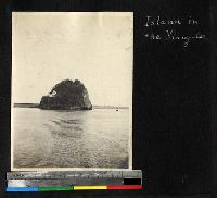
A tiny inhabited island sits in the middle of the Yangtze River. The island is a large rock with a steep incline. Several buildings are built on the sheer face of the rock., Also included in the International Mission Photography Archive., and This photo is from the papers of Dean Goddard, who was an American Baptist missionary in Ningpo, Che-chiang, China from 1870-1903.
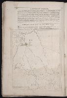
Great Britain. War Office. General Staff. Geographical Section
Published / Created:
1943
Call Number:
2121 1943
Container / Volume:
BRBL_00015
Image Count:
1
Resource Type:
Maps, Atlases & Globes
Alternative Title:
Geographical secton, General staff. ; no. 4313 and GSGS (Series) ; 4313.
Description:
"Copied from a Portuguese map dated 1934 with revision from intelligence reports.", Elevations shown by spot heights and contours at 25 meter intervals., Military grid., and Six classes of roads and tracks, and areas of cultivation and vegetation are indicated.
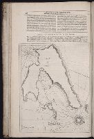
The West-India pilot: containing piloting directions for Port Royal and Kingston harbours in
Image Count:
1
Subject (Geographic):
Atlantic Ocean --Maps --Early works to 1800, Central America --Maps --Early works to 1800, Providence Island (Colombia) --Maps, and Santa Catalina Island (Colombia)
Subject (Topic):
Harbors --Atlantic Coast (North America) --Maps --Early works to 1800, Nautical charts --Atlantic Coast (North America) --Early works to 1800, Nautical charts --Caribbean Area --Early works to 1800, Nautical charts --West Indies --Early works to 1800, Pilot guides --Atlantic Coast (North America) --Early works to 1800, Pilot guides --Caribbean Area --Early works to 1800, and Pilot guides --West Indies --Early works to 1800
Collection Created:
London : Printed for the author and sold by S. Hooper ..., MDCCLXXI [1771]