Skip to search
Skip to main content
Skip to first result
Search
You Searched For
Extent of Digitization
Completely digitized
Genre
Maps
Publication Place
Paris :
New Search
Search Results
Creator:
Published / Created:
[1868?]
Call Number:
682H 1868
Container / Volume:
BRBL_00350
Image Count:
1
Resource Type:
Maps, Atlases & Globes
Description:
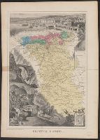
Inset of "Armes d'Alger" in lower right corner., Map of Algeria centered among pictorial representation of the town of Alger and a, and Shows civil and military regions noted by colors, agricultural colonies, regional boundaries, and elements of infrastructure.
Publisher:
Migeon,
Subject (Geographic):
Algeria--Maps
Found in:
Beinecke Rare Book and Manuscript Library > Province d'Alger / Dressé par A. Vuillemin.
Creator:
Published / Created:
[1868?]
Call Number:
682H 1868
Container / Volume:
BRBL_00350
Image Count:
1
Resource Type:
Maps, Atlases & Globes
Description:
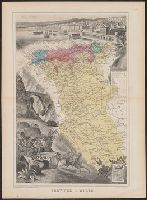
"Imp.e Migeon, Editeur, 11 rue du Moulin Vert, Paris.", Inset of "Armes d'Alger" in lower right corner., Map o, Scale in kilometres., and Shows civil and military regions noted by colors, agricultural colonies, regional boundaries, and elements of infrastructure.
Publisher:
Migeon,
Subject (Geographic):
Algeria--Maps
Found in:
Beinecke Rare Book and Manuscript Library > Province d'Alger / Dressé par A. Vuillemin.
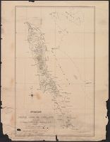
Published / Created:
1919
Call Number:
11hcf 1919D-46
Image Count:
1
Resource Type:
Maps, Atlases & Globes
Publisher:
D.J. Derocco,
Subject (Geographic):
Serbia--Maps and Yugoslavia--Maps
Found in:
Beinecke Rare Book and Manuscript Library > Railways of Jugoslavs countries.
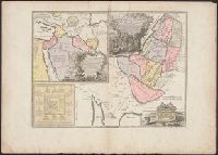
Published / Created:
1742
Call Number:
435hc 1742
Container / Volume:
BRBL_00252
Image Count:
1
Resource Type:
Maps, Atlases & Globes
Publisher:
Sr. le Rouge ... ,
Subject (Geographic):
Bohemia (Czech Republic)--Maps--Early works to 1800
Found in:
Beinecke Rare Book and Manuscript Library > Retraite de Monsieur le Marechal Duc de Pragá Egra.
Published / Created:
1919
Call Number:
11hcf 1919-6
Container / Volume:
BRBL_00010M
Image Count:
1
Resource Type:
Maps, Atlases & Globes
Description:
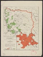
"Fragment d'après la carte ethnographique des ré́gions habité́es par les Roumains et des colonies é́trangères qui s'y trouvent."
Publisher:
Comité́ National de l'Unité́ Roumaine,
Subject (Geographic):
Serbia--Maps
Found in:
Beinecke Rare Book and Manuscript Library > Roumains des vallé́es du Timok, de la Mlava et du Pek, et Serbes du Banat / [par] Prof.r. Sc. Demetresco, C. Polyso, Prof.r. A.D. Atanasiu et Ed. Borcea. Paris, 1919.
Published / Created:
[1826?]
Call Number:
3818 1826
Container / Volume:
BRBL_00174
Image Count:
1
Resource Type:
Maps, Atlases & Globes
Description:
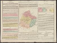
Statistics on margins of map.
Publisher:
Baudouin Frères,
Subject (Geographic):
Sarthe (France)--Maps
Found in:
Beinecke Rare Book and Manuscript Library > Sarthe.
Creator:
Published / Created:
1913
Call Number:
186 P93 1913
Container / Volume:
BRBL_00013
Image Count:
1
Resource Type:
Maps, Atlases & Globes
Alternative Title:
Map of Prince Charles Foreland
Description:
Accompanied by: Completion of the map of Prince Charles Foreland, by W.S. Bruce; reprinted from The Scottish Geographical Magazine, vol. xxix, Novembe, Map only., and Relief shown by contours, spot heights and landforms. Depths shown by soundings.
Publisher:
Erhard Frers.,
Subject (Geographic):
Prince Charles Foreland (Norway)--Maps
Subject (Name):
Mathieson, J
Found in:
Beinecke Rare Book and Manuscript Library > Spitsbergen, map of Prince Charles Foreland / from surveys by W.S. Bruce ; & J. Mathieson ; assisted by J.V. Burn ... [et al.] ; published with the support of H.S.H. the Prince of Monaco.
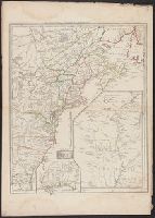
Published / Created:
1782
Call Number:
755 1782C
Container / Volume:
BRBL_00433
Image Count:
1
Resource Type:
Maps, Atlases & Globes
Publisher:
Chez Esnauts et Rapillay,
Subject (Geographic):
East (U.S.)--Maps--Early works to 1800
Found in:
Beinecke Rare Book and Manuscript Library > Suite du Thèatre de la Guerre dans L'Amérique Septentrionale y compris le Golfe du Méxique. Par M. Brion de la Tour.
Published / Created:
[1655?]
Call Number:
51 1743
Container / Volume:
BRBL_00279
Image Count:
1
Resource Type:
Maps, Atlases & Globes
Description:
Arche de L'Alliance ..., Disposition du camp des Israelites autour de L8, and Insets: Carte des Voiages d' Abraham ...
Publisher:
Chez Delamarche,
Subject (Geographic):
Palestine--Maps--Early works to 1800
Found in:
Beinecke Rare Book and Manuscript Library > Terre de Chanaan on Terre Promise a Abraham ... G. Sanson ...
Published / Created:
1777
Call Number:
755 1777C
Container / Volume:
BRBL_00431
Image Count:
1
Resource Type:
Maps, Atlases & Globes
Description:
See Phillips 589-9. and View of Niagara Falls.
Publisher:
Sr. le Rouge Ingenieur Geographe du Roy,
Subject (Geographic):
Canada--Maps--Early works to 1800 and East (U.S.)--Maps--Early works to 1800
Found in:
Beinecke Rare Book and Manuscript Library > Theatre de la Guerre en Amérique.
Branch:v1.61.8 ,Deployed:2024-06-20T11:14:55-04:00