Skip to search
Skip to main content
Skip to first result
Search
You Searched For
Extent of Digitization
Completely digitized
Genre
Maps
Creator
United States. Office of Strategic Services. Research and Analysis Branch
New Search
Search Results
Creator:
Published / Created:
1945
Call Number:
36cb 1945A
Container / Volume:
BRBL_00127
Image Count:
1
Resource Type:
Maps, Atlases & Globes
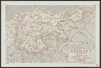
Description:
Dated: 7 April 1945., Includes most of western Poland., Inset: [Location map], and Relief indicated by color.
Publisher:
OSS,
Subject (Geographic):
Gdańsk Region (Poland)--Maps and Germany--Maps
Found in:
Beinecke Rare Book and Manuscript Library > Germany eastern border regions : surface configuration.
Creator:
Published / Created:
1945
Call Number:
36f R857 1945
Container / Volume:
BRBL_00128
Image Count:
1
Resource Type:
Maps, Atlases & Globes
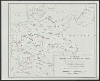
Description:
"No. 6333." and Includes location map inset.
Publisher:
R & A, OSS,
Subject (Geographic):
Germany (West)--Administrative and political divisions--Maps and Germany (West)--Maps
Found in:
Beinecke Rare Book and Manuscript Library > Germany, Western border regions, critical
Creator:
Published / Created:
1943
Call Number:
36gf 1943
Container / Volume:
BRBL_00130
Image Count:
1
Resource Type:
Maps, Atlases & Globes
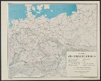
Description:
"From: OSS Map no. 1345, revised Oct. 16, 1943"., "Note: Circles indicate concentration of machine tool industries.", and "Project NO. E.O.53".
Publisher:
R & A, OSS,
Subject (Geographic):
Germany--Maps
Subject (Topic):
Machine-tools--Germany--Manufacture and trade--Maps
Found in:
Beinecke Rare Book and Manuscript Library > Germany, centers of machine tool production / Board of Economic Warfare, Enemy Branch.
Branch:v1.61.8 ,Deployed:2024-06-20T11:14:55-04:00