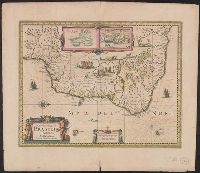
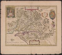
Baya de todos os Sanctos. and Villa d'Olinda de Pernambuco.
Description:
Bar scales in "Milliaria Germanica communia" and "Milliaria Gallica communia.", Cross Collection no. 339., From Hondius's Atlantis novi ... [Amsterdam] : Sumptibus & typis aeneis Henrici Hondij ..., 1638., Hand col., In Latin on verso, with caption title "Brasilia" and signature 5B., Insets: [1] Baya de todos os Sanctos -- [2] Villa d'Olinda de Pernambuco., Oriented with north to the right., Relief shown pictorially., and Shows the coast of Brazil from San Marcos bay to modern Curityba.
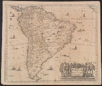
Cross Collection no. 322., From Jan Jansson's Nouvel atlas ou theatre du monde ... Amsterodami : Apud Ioannem Ianssonium, 1647., In French on verso, with caption title "L'Amerique Meridionale" and signature 4L., and Relief shown pictorially.
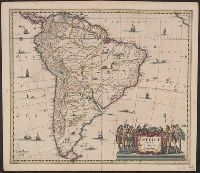
Cross Collection no. 321., From Gerardi Mercatoris atlantis novi ... Amsterodami : Sumptibus & typis aenis Henrici Hondij, 1638., In Latin on verso, with caption title "Descriptio Americae meridionalis" and signature 4Y., and Relief shown pictorially.
Publisher:
Sumptibus Henrici Hondy,
Subject (Geographic):
South America--Maps--Early works to 1800
Subject (Name):
Hondius, Hendrik, 1597-1651 and Mercator, Gerhard, 1512-1594. Atlas
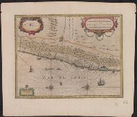
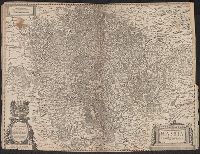
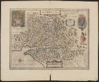
Bar scales i, Cross Collection no. 348., From Jan Jansson and Henrik Hondius's Atlas novus ... Amstelodami : Apud Ionnem Ianssonium & Henricum Hondium, 1638., Hand col., Oriented with north to the left., and Relief shown pictorially.
Publisher:
Henricus Hondius excudit,
Subject (Geographic):
Chile--Maps--Early works to 1800
Subject (Name):
Hondius, Hendrik, 1597-1651. Atlas novus and Jansson, Jan, 1588-1664. Atlas novus
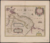
Gviana siue Amazonvm regio and Gviana sive Amazonvm regio
Description:
Bar scales in "Milliaria Germanica communia" and "Milliaria Gallica communia.", Cross Collection no. 338., From, Hand col., In Latin on verso, with caption titles "Guianae descriptio" and signature 5A., and Relief shown pictorially.
Bar scales given in "milliaria Hassiaca" and "milliaria Germanica communica.", From Henricus Hondius and Joannes Janssonius's Atlas (English ed.), 1636., Imperfect: edges chipped and frayed, with some loss of text. Sheet measures 42.4 x 56.2 cm., and Includes de
Publisher:
Sumptibus Henrici Hondii,
Subject (Geographic):
Hesse (Germany)--Maps--Early works to 1800 and North Rhine-Westphalia (Germany)--Maps--Early works to 1800
Subject (Name):
Hondius, Hendrik, 1597-1651. Atlas novus. English and Jansson, Jan, 1588-1664. Atlas novus. English
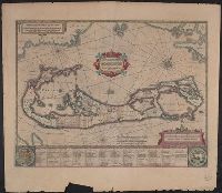
Insulae vel Insularum quas Bermudes vocant, descriptio, Insularum Bermudes, and Mappa Aestivarvm Insularum
Description:
At bottom of map "Nomina fortunae bona Submittentium in quaestus Virginiani alea A.⁰ 1622 ...", Cross Collection no. 65., From Jansonius's and Hondius's Atlas novus ... Amstelodami : Apud Ionnem Ianssonium & Henricum Hondium, 1638., and Signature 4Q on verso.
Publisher:
Apud Henricum Hondium,
Subject (Geographic):
Bermuda Islands--Maps--Early works to 1800
Subject (Name):
Hondius, Hendrik, 1597-1651. Atlas novus and Jansson, Jan, 1588-1664. Atlas novus
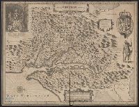
French text on verso, with running and caption title "Virginie," signature e, and catchword "ses.", From Jan Jansson's Nouvel atlas ... Amstelodami : Apud Ioannem Ianssonium, 1646-1649., Hendrik Hondius' derivative of John Smith's map of Virginia, 1612., and Ori
Publisher:
Ex officina Henrici Hondii,
Subject (Geographic):
Chesapeake Bay (Md. and Va.)--Maps--Early works to 1800, Maryland--Maps--Early works to 1800, and Virginia--Maps--Early works to 1800
Subject (Name):
Jansson, Jan, 1588-1664. Atlas novus. French and Smith, John, 1580-1631
Dutch text on verso, with running and caption title "Virginia," signature 2D, and catchword "riviere.", Hendrik Hondius' derivative of John Smith's map of Virginia, 1612., Oriented with north toward the right., Relief shown pictorially., and Royal arms in upper r
Publisher:
Ex officina Henrici Hondii,
Subject (Geographic):
Chesapeake Bay (Md. and Va.)--Maps--Early works to 1800, Maryland--Maps--Early works to 1800, and Virginia--Maps--Early works to 1800
Subject (Name):
Jansson, Jan, 1588-1664. Atlas novus. Dutch and Smith, John, 1580-1631
Hand col. Sheet measures 50.8 x 58.2 cm. Cross Collection no. 213., Hendrik Hondius' derivative of John Smith's map of Virginia, 1612., In Latin on verso, with running and caption title "Virginia," signature 4R, and catchword "fluvio-"., Oriented with north toward the right., Relief shown pictorially., and Royal arms in upper right.
Publisher:
Ex officina Henrici Hondii,
Subject (Geographic):
Chesapeake Bay (Md. and Va.)--Maps--Early works to 1800, Maryland--Maps--Early works to 1800, and Virginia--Maps--Early works to 1800