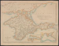
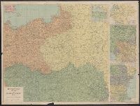
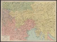
Daily telegraph (London, England), Daily Telegraph war map ; no. 5, and Daily Telegraph war map ; no. 5.
Description:
Daily Telegraph war map of eastern Europe (no. 5) -- Black Sea & adjacent countries -- Russia -- Western Balkans -- Eastern Balkans., Includes 4 inset maps., Index inserted in cover., and Relief shown by hachures and spot heights.
Publisher:
Geographia Ltd.,
Subject (Topic):
World War, 1914-1918--Campaigns--Europe, Eastern--Maps and World War, 1914-1918--Europe, Eastern--Maps
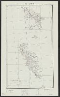
Daily telegraph (London, England) and War map no. 12
Description:
General map; does not show campaigns., Includes inset of northeastern Turkey (scale ca. 1:580,000; 32 x 25 cm.)., and Relief shown by gradient tints and spot heights.
Publisher:
"Geographia" Ltd.,
Subject (Geographic):
Dardanelles Strait (Turkey)--Maps and Gallipoli Peninsula (Turkey)--Maps
Subject (Name):
Geographia Ltd
Subject (Topic):
World War, 1914-1918--Turkey--Gallipoli Peninsula--Maps
Great Britain. War Office. General Staff. Geographical Section
Published / Created:
1940
Call Number:
342 1944
Container / Volume:
BRBL_00092
Image Count:
2
Resource Type:
Maps, Atlases & Globes
Alternative Title:
G.S.G.S. ; 4139 and GSGS (Series) ; 4139.
Description:
Contents: North sheet -- South sheet., Contours at 50 meters interval., Copied from a Danish map of 1932., Four classes of roads are shown., and Military grid.