Search
You Searched For
Search Results
- Call Number:
- 1973 Folio 114
- Collection Title:
- The English pilot: describing the West-India navigation, from Hudson's-Bay to the river Amazones
- Image Count:
- 1
- Resource Type:
- Maps, Atlases & Globes
- Subject (Geographic):
- Atlantic Ocean --Maps --Early works to 1800, Central America --Maps --Early works to 1800, and Panama --Maps --Early works to 1800
- Subject (Topic):
- Navigation --Early works to 1800, Pilot guides --Atlantic Coast (U.S.) --Early works to 1800, and Pilot guides --Caribbean Area --Early works to 1800
- Collection Created:
- London : Printed for W. and J. Mount, T. Page and son, on Tower-Hill, MDCCLIX [1759]
- Found in:
- Beinecke Rare Book and Manuscript Library > An exact draught of the Gulf of Darien & the coast to Porto Bello with Panama in the South Sea & the Scotch settlement in Calledonia
- Creator:
- Moll, Herman, d. 1732
- Published / Created:
- [178-?]
- Call Number:
- 1973 Folio 113
- Image Count:
- 2
- Resource Type:
- Maps, Atlases & Globes
- Alternative Title:
- New and curious set of sixty two maps.
- Description:
- "The United States of North America, with the British & Spanish territories": no. 46. and Title-page engraved.
- Publisher:
- Printed for R. Wilkinson, at No. 58 in Cornhill
- Subject (Topic):
- Atlases--Early works to 1800 and Geography--Early works to 1800
- Found in:
- Beinecke Rare Book and Manuscript Library > Atlas minor: or A new and curious set of sixty two maps, in which are shewn all the empires, kingdoms, countries, states in all the known parts of the earth ... by Herman Moll ...
- Call Number:
- 1973 Folio 114
- Collection Title:
- The English pilot: describing the West-India navigation, from Hudson's-Bay to the river Amazones
- Image Count:
- 1
- Resource Type:
- Maps, Atlases & Globes
- Subject (Geographic):
- Atlantic Ocean --Maps --Early works to 1800 and Barbados --Maps --Early works to 1800
- Subject (Topic):
- Navigation --Early works to 1800, Pilot guides --Atlantic Coast (U.S.) --Early works to 1800, and Pilot guides --Caribbean Area --Early works to 1800
- Collection Created:
- London : Printed for W. and J. Mount, T. Page and son, on Tower-Hill, MDCCLIX [1759]
- Found in:
- Beinecke Rare Book and Manuscript Library > Barbados
- Call Number:
- 1973 Folio 114
- Collection Title:
- The English pilot: describing the West-India navigation, from Hudson's-Bay to the river Amazones
- Image Count:
- 1
- Resource Type:
- Maps, Atlases & Globes
- Subject (Geographic):
- Atlantic Ocean --Maps --Early works to 1800 and Newfoundland and Labrador --Maps --Early works to 1800
- Subject (Topic):
- Navigation --Early works to 1800, Pilot guides --Atlantic Coast (U.S.) --Early works to 1800, and Pilot guides --Caribbean Area --Early works to 1800
- Collection Created:
- London : Printed for W. and J. Mount, T. Page and son, on Tower-Hill, MDCCLIX [1759]
- Found in:
- Beinecke Rare Book and Manuscript Library > Bay Bulls, part of Newfoundland
- Call Number:
- 1977 +392
- Collection Title:
- A survey of the cities of London and Westminster : containing the original, antiquity, increase
- Image Count:
- 1
- Resource Type:
- Maps, Atlases & Globes
- Description:
- Plate between p. 90-91.
- Subject (Geographic):
- London (England)--History
- Collection Created:
- London : Printed for A. Churchill, J. Knapton, R. Knaplock, J. Walthoe [and 6 others], 1720
- Found in:
- Beinecke Rare Book and Manuscript Library > Bishop Gate Street Ward taken from the last survey and corrected
- Creator:
- Inselin, C
- Call Number:
- 1977 Folio 114
- Collection Title:
- L’atlas curieux ou Le monde represente dans des cartes generales et particulieres du ciel et de la
- Image Count:
- 1
- Resource Type:
- Maps, Atlases & Globes
- Description:
- Verso blank.
- Subject (Geographic):
- Fontainebleau (France)
- Subject (Topic):
- Atlases, French
- Collection Created:
- A Paris, Chez l’auteur dans l’Isle du Palais sur le quay de l’Orloge a la Sphere Royale, 1700[-03]
- Found in:
- Beinecke Rare Book and Manuscript Library > Bourg, chateau, et iardins de Fontaine-bleau
- Call Number:
- 1977 +392
- Collection Title:
- A survey of the cities of London and Westminster : containing the original, antiquity, increase
- Image Count:
- 1
- Resource Type:
- Maps, Atlases & Globes
- Description:
- Plate between p. 14-15.
- Subject (Geographic):
- London (England)--History
- Collection Created:
- London : Printed for A. Churchill, J. Knapton, R. Knaplock, J. Walthoe [and 6 others], 1720
- Found in:
- Beinecke Rare Book and Manuscript Library > Bread Street Ward and Cordwainer Ward with it's division into parishes taken from the last survey
- Published / Created:
- [1560]
- Call Number:
- Peru Cwpr j553ci
- Collection Title:
- La prima parte dell historie del Perv. Dove si tratta lordine delle prouincie, delle citta nuoue in
- Image Count:
- 1
- Resource Type:
- Maps, Atlases & Globes
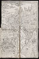
- Subject (Geographic):
- Central America. and South America
- Subject (Topic):
- Discoveries in geography
- Collection Created:
- In Venetia, Appresso Giordano Ziletti, al segno della Stella.
- Found in:
- Beinecke Rare Book and Manuscript Library > Brevis exactaq totivs novi orbis eivsq; insvlarvm descriptio recens a ioan bellero edita
- Published / Created:
- [1567]
- Call Number:
- Peru Cwpr j567
- Collection Title:
- Levini Apollonii, Gandobrvgani, Mittelbvrgensis, de Peruuiae, regionis, inter Noui Orbis prouincias
- Image Count:
- 1
- Resource Type:
- Maps, Atlases & Globes
- Description:
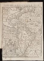
- Scale included.
- Subject (Geographic):
- Andes., Central America., Peru --History --Conquest, 1522-1548., and South America
- Subject (Topic):
- Discoveries in geography
- Collection Created:
- Antverpiae, Apud Ioannem Bellerum,
- Found in:
- Beinecke Rare Book and Manuscript Library > Brevis, exactaq totivs novi orbis et Pervviae regionis descriptio recens edita
- Call Number:
- 1977 +392
- Collection Title:
- A survey of the cities of London and Westminster : containing the original, antiquity, increase
- Image Count:
- 1
- Resource Type:
- Maps, Atlases & Globes
- Description:
- Plate between p. 150-151.
- Subject (Geographic):
- London (England)--History
- Collection Created:
- London : Printed for A. Churchill, J. Knapton, R. Knaplock, J. Walthoe [and 6 others], 1720
- Found in:
- Beinecke Rare Book and Manuscript Library > Candlewick Ward with its division into parishes. Corrected from the last survey