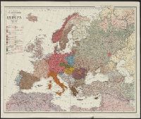
Haberlandt, Arthur, b. 1889 Kartographische Anstalt Freytag und Berndt
Published / Created:
[1915?]
Call Number:
30ed 1915
Container / Volume:
BRBL_00037B
Image Count:
2
Resource Type:
Maps, Atlases & Globes
Alternative Title:
G. Freytag's Karte von Europa and Völkerkarte von Europa
Description:
Shows areas of ocean under British, Russian, French and Italian control: "Sperrgebiet um England, Russland, Frankreich und Italien." and Shows old and new borders and the languages spoken within those regions.
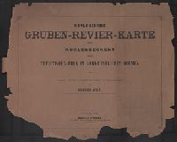
Accompanied by cover sheet with variant title: Geologis, Relief shown by contours and spot heights., Sheets 3, 4, and 6 thru 15 are map sheets. Geological cross-sections on sheets 1, 2, and 5; title and legend on sheet 16., and Title from title sheet (Blatt 16).
Publisher:
Alfred Hölder,
Subject (Topic):
Coal mines and mining--Czech Republic--Duchcov Region--Maps, Coal mines and mining--Czech Republic--Most Region--Maps, Coal mines and mining--Czech Republic--Teplice Region--Maps, and Mining geology--Czech Republic--Duchcov Re