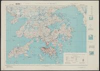
Great Britain. War Office. General Staff. Geographical Section
Published / Created:
1945
Call Number:
5681 1945
Container / Volume:
BRBL_00300
Image Count:
2
Resource Type:
Maps, Atlases & Globes
Alternative Title:
GSGS (Series), Hong Kong and Lema Islands, Hong Kong and Lema Islands., and Hong Kong and New territory.
Description:
"7-45.", "8-45.", "Reproduced under the direction of the Chief of Engineers by the Army Map Service (AM), U.S. Army ... 1945, from Kodalines of GSGS Second Edition 1945...", and North sheet. Hong Kong and New territory -- South sheet. Hong Kong and Lema Islands.
Publisher:
Army Map Service, U.S. Army,
Subject (Geographic):
Hong Kong (China)--Maps and New Territories (China)--Maps
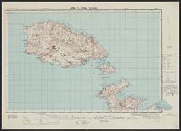
Great Britain. Army. Royal Engineers. Fd. Survey Coy., 512
Published / Created:
1943
Call Number:
493 1943
Container / Volume:
BRBL_00270
Image Count:
2
Resource Type:
Maps, Atlases & Globes
Alternative Title:
Geographical Section, General Staff ; no. 3859, Great Britain. Army. Middle East Forces. M.D.R ; 582., and GSGS (Series) ; 3859.
Description:
"[Gt. Brit. Army. Middle East Forces.] M.D.R. 582.", Includes glossary., Inset on sheet 2: Island of Fifia., Marginal maps: Reliability diagram -- Actual position of Fifia., Relief shown by contours, "interval 25 feet" ; depths shown by isolines., and Shows five c
Publisher:
Army Map Service, U.S. Army,
Subject (Geographic):
Gozo Island (Malta)--Maps and Malta--Maps
Subject (Name):
Great Britain. War Office. General Staff. Geographical Section and United States. Army Map Service
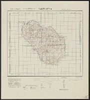
Great Britain. War Office. General Staff. Geographical Section
Published / Created:
1943
Call Number:
40 P19 1942
Container / Volume:
BRBL_00213
Image Count:
1
Resource Type:
Maps, Atlases & Globes
Alternative Title:
Geographical Section, General Staff ; no. 4162 and GSGS (Series) ; 4162.
Description:
"3-43.", "Copied from an Italian map of 1896.", "Grid added November 1942.", Military grid., and Relief shown by contours, rock drawings, and spot heights.
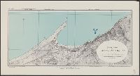
"A.M.S. 5301.", Cloth map (silk)., For further information see a Web site devoted to the history and identification of the AAF cloth maps., Heights and depths in meters., Includes: Index to boundarie, and Relief shown by gradient tints, contours, and spot heights.
Publisher:
Amy Map Service,
Subject (Geographic):
East Asia--Maps
Subject (Name):
United States. Army Map Service
Subject (Topic):
Military geography--Japan--Kagoshima--Maps, Military geography--Japan--Nagasaki--Maps, Military maps, Military topography--Japan--Kagoshima--Maps, and Military topography--Japan--Nagasaki--Maps