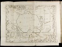
Kingdom of France divided into all its provinces, comprehended under twelve generall governments viz. ... described by Sanson, corrected and amended by William Berry
Description:
Bar scales given in Italian miles, common leagues of France, great leagues of France, common leagues of Germany, great leagues of Germany, English miles, and common leagues of Spain., Ms. mathematical computations on right margin., No. 12 of 69 maps bound together in composite atlas., Relief shown pictorially., Scale [ca. 1:2 100 000]., and With dedication To the most serene and most sacred Majesty Charles II ... from William Berry.
Publisher:
Sold by William Berry at the sign of the Globe between Charing-Cross and White-Hall
Subject (Geographic):
Europe, Central --Maps --Early works to 1800 and France --Maps --Early works to 1800
Blaeu, Joan, 1596-1673. Theatrum orbis terrarum Blaeu, Willem Janszoon, 1571-1638 Blaeu, Willem Janszoon, 1571-1638. Theatrum orbis terrarum
Published / Created:
[ca. 163-?]
Call Number:
1983 Folio 19
Collection Title:
[Atlas factice of 96 maps by Blaeu, Visscher, Jansson, Hondius and others]
Image Count:
2
Resource Type:
Maps, Atlases & Globes
Alternative Title:
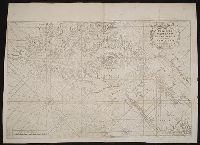
Imperium Turcicum in Europa, Asia et Africa regiones proprias, tributar, et clientelares exhibens and Turcicum imperium
Description:
Imperfect: torn and mutilated along fold and edges, partially repaired, with some loss of text; cartouche cut-out and replicated in ms. with new title.
The English pilot: describing the West-India navigation, from Hudson's-Bay to the river Amazones
Image Count:
2
Subject (Geographic):
Atlantic Ocean --Maps --Early works to 1800, Maryland --Maps --Early works to 1800, New Jersey --Maps --Early works to 1800, and Virginia --Maps --Early works to 1800
Subject (Topic):
Navigation --Early works to 1800, Pilot guides --Atlantic Coast (U.S.) --Early works to 1800, and Pilot guides --Caribbean Area --Early works to 1800
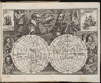
Jovrnal ou Description dv merveillevx voyage de Gvillavme Schovten, hollandois natif de Hoorn
Image Count:
1
Abstract:
Depicts notable explorers of the time as well as two ships, the Victoria and the Eendracht.
Description:
Bound in preceding first page of text., In ink on recto: Olivier van Nort [sic]., and Scale not given.
Subject (Geographic):
Eastern Hemisphere --Maps --Early works to 1800 and Western Hemisphere --Maps --Early works to 1800
Subject (Name):
Cavendish, Thomas, 1560-1592, Drake, Francis, Sir, 1540?-1596, Magalhaes, Fernao de, d. 1521, Noort, Olivier van, 1558 or 9-1627, Schouten, Willem Corneliszoon, d. 1625, and Spilbergen, Joris van, 1568?-1620
Subject (Topic):
Voyages around the world --To 1700
Collection Created:
A Amstredam : Chez Harman Ianson, marchand libraire, demeurant en la VVarmoes-straet, a le Sereine, 1619