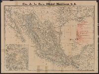
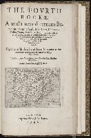
Indexed atlas of the world map of Mexico, Plano general de la ciudad de Mexico., and Rand, McNally & Co.'s indexed atlas of the world map of Mexico
Description:
"Cia. de la Guia Oficial Mexicana S.A.", Includes index to railroads and "Map of the Valley of Mexico, on enlarged scale" (scale [ca. 1:300,000])., On verso: Plano general de la ciudad de Mexico / formado de esprofeso p.a la C.a de la Guia Oficial Mexicana ; Luis G. Becerril. Scale 1:15,000. 1903., and Relief shown by hachures and spot heights.
Publisher:
Rand, McNally,
Subject (Geographic):
Mexico City (Mexico)--Maps and Mexico--Maps
Subject (Name):
Cia. de la Guia Oficial Mexicana S.A
Subject (Topic):
Railroads--Mexico--Maps and Streets--Mexico--Mexico City--Maps
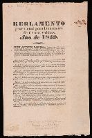
Folder also contains photostat of a similar notice in the Louisiana Advertiser, 1823 May 23., Photocopy (negative) of the Bancroft Library copy. 1 l. 60 x 44 cm., Spanish and English in two columns., and Streeter no. 4.
Coahuila and Texas (Mexico). Comisionado General para el Repartimiento de Tierras Valdias
Published / Created:
1829]
Call Number:
Zc52 829co
Image Count:
4
Description:
Caption title., Dated and signed at end: San Felipe de Austin, December 21st 1829. Juan Antonio Padilla., Streeter no. 15., and Text in Spanish and English.
Publisher:
Printed by G.B. Cotten,
Subject (Topic):
Surveying--Public lands--Texas and Surveying--Texas
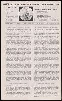
Mexican citizen and Texas gazette (San Felipe, Tex.)
Description:
Continued by: Texas gazette and Brazoria commercial advertiser., Imperfect: many issues mutilated with loss of text., Sometimes published as: Mexican citizen with its own volume and number, Mar. 17-May 26, 1831., and Vol. 1, no. 7, 1829 is photocopy.
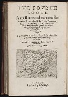
Historia general de los hechos de los castellanos. Selections. English
Description:
An abridged translation of the first three decades of Herrera's "Historia general de los hechos de los castellanos," first published in Madrid, 1601-1615., Frontispieces and further plates include: portrait of Christopher Columbus (vol. 1). -- 'A new map of South America' (vol. 2). -- 'A new map of as much of North and South America ... ' (vol. 3). -- "An hidrographical draught of Mexico as it lies in its lakes"(vol. 3) -- portrait of Ferdinand Cortes (vol. 4) -- minature portraits on frontispiece of 'The five most famous men in Peru and Chile' (vol. 5). -- illustration of 'The people of Florida sacrificing their first born to the sun'., Includes decorative head- and tail-pieces and initial letters., The preface in volume 1 is in six pages, and the headpiece to the preface and to page 1 represents a hill with a flag on top, with a sun in the background; Sig. B is under the 'a' of "Seneca.", Title page printed in red and black., and Volumes 1 and 2 dated 1725; volumes 3-6 dated 1726.
Subject (Geographic):
America--Discovery and exploration--Spanish, America--Early accounts to 1600, and Latin America--History--To 1600--Early works to 1800
Subject (Name):
Batley, Jeremiah, -1737, Dalkeith Palace Bookplate, and Stevens, John, -1726
Subject (Topic):
Chron--1725-1726 and Slaves--Latin American--Early works to 1800