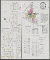
Fire insurance map, colored to show building construction, property boundaries and house and block numbers.
Alternative Title:
Aug. 1923, Bridgeville, Del. and Bridgeville, Del.
Description:
Coordinates not present on map and are approximated., Sheet 1 includes key to building colors and other features of construction, water facilities and fire department, index map for the adjoining sheets, and information about updates., Stamps below title: 427,0, Oct. 22, 1923., and Title from sheet 1.
Publisher:
Sanborn Map Company,
Subject (Geographic):
Bridgeville (Del.)--Maps.
Subject (Topic):
Fire risk assessment--Delaware--Bridgeville--Maps. and Real property--Delaware--Bridgeville--Maps.
Fire insurance map, colored to show building construction, property boundaries and house and block numbers.
Alternative Title:
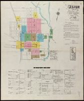
Dover, Del., Dover, Delaware, and June 1919, Dover, Del.
Description:
"15 sheets (2729).", Coordinates not present on map and are approximated., Includes index to streets and buildings., Sheet 1 includes key to building colors and other features of construction, water facilities and fire department, index map for the adjoining sheets., and Stamps on sheet 1: CLF 33650; Sep. 9, 1919.
Publisher:
Sanborn Map Company,
Subject (Geographic):
Dover (Del.)--Maps.
Subject (Topic):
Fire risk assessment--Delaware--Dover--Maps. and Real property--Delaware--Dover--Maps.
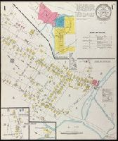
Fire insurance map, colored to show building construction, property boundaries and house and block numbers.
Alternative Title:
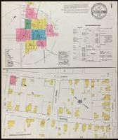
Georgetown, Del., Georgetown, Delaware, and Oct. 1919, Georgetown, Del.
Description:
"2866 (7 sheets).", Coordinates not present on map and are approximated., Includes index to streets and buildings., Sheet 1 includes key to building colors and other features of construction, water facilities and fire department, index map for the adjoining sheets., and Stamps on sheet 1: CLF 33812; Dec. 31, 1919.
Publisher:
Sanborn Map Company,
Subject (Geographic):
Georgetown (Del.)--Maps.
Subject (Topic):
Fire risk assessment--Delaware--Georgetown--Maps. and Real property--Delaware--Georgetown--Maps.
Sanborn fire insurance maps are a rich source of historic data on the urban built environment of North America during the 19th and early 20th centuries. The atlases were created for the purpose of underwriting fire insurance policies, which depended upon accurate and frequently-updated information about construction materials, municipal and transportation infrastructure, industrial and commercial landuse and more. The Yale University Library Map Department scanned its holdings of Sanborn fire insurance maps (consisting primarily of Connecticut towns) in order to make the maps more accessible.
Alternative Title:
Insurance maps of New Haven, Connecticut, including East Haven, Insurance maps of New Haven, Connecticut, including Hamden and North Haven, Insurance maps of New Haven, Connecticut, including West Haven, and New Haven, Connecticut
Description:
Partial cadastral maps., Sheets contain information on population, water facilities and fire departments., SMLMAPL 766 N46 1924: Sheets disbound., Volume 1 includes "Map of Congested District" and 10 skeleton maps., Volume 3 includes 2 skeleton maps., Volume 5: sheets 514-516, 532, 556, 557, and 563-577 noted on index map as "proposed.", and Volumes include indices of streets and specials.
Subject (Geographic):
East Haven (Conn.)--Maps, Hamden (Conn.)--Maps, New Haven (Conn.)--Maps, North Haven (Conn.)--Maps, and West Haven (Conn.)--Maps
Subject (Name):
Library of Congress Ownership
Subject (Topic):
Fire risk assessment--Connecticut--East Haven--Maps, Fire risk assessment--Connecticut--Hamden--Maps, Fire risk assessment--Connecticut--New Haven--Maps, Fire risk assessment--Connecticut--North Haven--Maps, Fire risk assessment--Connecticut--West Haven--Maps, Real property--Connecticut--East Haven--Maps, Real property--Connecticut--Hamden--Maps, Real property--Connecticut--New Haven--Maps, Real property--Connecticut--North Haven--Maps, and Real property--Connecticut--West Haven--Maps
Plan showing the fire insurance risks of buildings in a city or town. Identifies commercial, industrial, and residential sections. Successive Sanborn maps show the physical evolution of buildings and neighborhoods in a given town.
Alternative Title:
Portsmouth, Va
Description:
"120 sheets ... (3124).", Coordinates not present on map and are approximated., Imperfect: all sheets after 21 wanting. Includes skeleton maps for sheets 3-6., Includes "Map of congested district of Portsmouth, Va." (scale 1:2,400)., Includes West Norfolk and Pinners Point., and Shows color-coded building construction material, locations of windows and doors, roof type, street widths and names, water facilities, proximity to fire stations, and population size.
Publisher:
Sanborn Map Company,
Subject (Geographic):
Portsmouth (Va.)--Maps
Subject (Topic):
Fire risk assessment--Virginia--Portsmouth--Maps. and Real property--Virginia--Portsmouth--Maps.
Fire insurance map, colored to show building construction, property boundaries and house and block numbers.
Alternative Title:
Milford, Del., Milford, Delaware, and Nov. 1919, Milford, Del.
Description:
"15 sheets (2932).", Coordinates not present on map and are approximated., Includes index to streets and buildings., Sheet 1 includes key to building colors and other features of construction, water facilities and fire department, index map for the adjoining sheets., and Stamps below title: CLF 33891; Feb. 13, 1920.
Publisher:
Sanborn Map Company,
Subject (Geographic):
Milford (Del.)--Maps.
Subject (Topic):
Fire risk assessment--Delaware--Milford--Maps. and Real property--Delaware--Milford--Maps.
Fire insurance map, colored to show building construction, property boundaries and house and block numbers.
Alternative Title:
July 1923, Milton, Del. and Milton, Del.
Description:
"1131 (3 sheets).", Coordinates not present on map and are approximated., Index map at scale of 600 feet to 1 inch, or 1:7,200., Maps on sheets 1 and 3 are at a scale of 1:1200, map on sheet 2 is at a scale of 1:600., Partial cadastral map., and Sheet 1 includes key to building colors and other features of construction, water facilities and fire department, index map for the adjoining sheets, and information about updates.
Publisher:
Sanborn Map Company,
Subject (Geographic):
Milton (Del.)--Maps.
Subject (Topic):
Fire risk assessment--Delaware--Milton--Maps. and Real property--Delaware--Milton--Maps.