Copy 2: Mounted on linen. Sheet measures 57.3 x 79 cm. Ms. no. on verso: No. 6., Imprint date from Tooley., Includes descriptive text., and Relief shown pictorially.
Publisher:
Chez l'auteur sur le Quai de l'Horloge a l'Aigle d'Or,
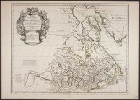
Appeared in L'Isle's Atlas géographique et universal., Includes descriptive text., Lower left: Ph. Buache ... Gendre de l'auteur, avec Privilege du 30 Au. 1745., Relief shown pictorially., and Sheet measures 54.7 x 76.5 cm. Ms. nos. on verso: 52.
Publisher:
Philippe Buache],
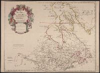
Subject (Geographic):
Canada--Maps--Early works to 1800 and New France--Maps--Early works to 1800
Subject (Name):
Buache, Philippe, 1700-1773 and L'Isle, Guillaume de, 1675-1726. Atlas géographique et universal
1st state of re-engraved, close copy of L'Isle's map of the same title (Kershaw 284)., According to Ke, According to Kershaw, this map is copied with only slight alteration from the Del'Isle map of Canada., Cross collection no. 169., and Relief shown pictorially.
Publisher:
chez Pierre Mortier,
Subject (Geographic):
Canada--Maps--Early works to 1800 and North America--Maps--Early works to 1800
Subject (Name):
L'Isle, Guillaume de, 1675-1726 and Ottens Joachim, 1663-1719
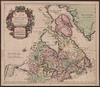
Based on Guillaume de L'Isle's Carte du Canada ... 1703., From Chatelain's Atlas historique ... Amsterdam : Chez L'Honoré & Châtelain, 1718-21., In upper right corner: Tom: VI. No: 20. Pag: 82., Includes text., Reli, and Sheet measures 45.3 x 57.1 cm.
Publisher:
Chez l'Honore & Chatelain Libraires,
Subject (Geographic):
Canada--Maps--Early works to 1800 and New France--Maps--Early works to 1800
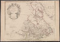
"Avec privilege Janvier 1708.", "The words 'premier geographe du Roi' added in the title ... [indicate] that [a map] could not have been issued before 1718 when [De l'Isle] was appointed to that office"--Tooley, R.V. Guide to maps, and Relief shown pictorially.
Publisher:
chez l'auteur sur le Quai de l'Horloge,
Subject (Geographic):
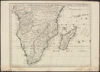
Africa, Central--Maps--Early works to 1800 and Africa, Southern--Maps--Early works to 1800
Atlas geographique et physique des regions equinoxiales du nouveau continent, fonde sur des
Image Count:
1
Resource Type:
Maps, Atlases & Globes
Description:
At foot: Redige et dessine d'apres des esquisses de Mr de Humboldt par J.B. Poirson 1813. / Grave par P.A.F. Tardieu, Place de l'Estrapade No 34. and Scale included
Subject (Geographic):
Orinoco River (Venezuela and Colombia) and South America
Subject (Topic):
Discoveries in geography, Explorers, Scientific expeditions, and Voyages and travels