Skip to search
Skip to main content
Skip to first result
Search
You Searched For
Extent of Digitization
Partially digitized
Genre
Hand coloring
Genre
Maps
New Search
Search Results
Published / Created:
1850
Call Number:
1976 Folio 96
Collection Title:
A new universal atlas containing maps of the various empires, kingdoms, states and republics of the
Image Count:
1
Resource Type:
Maps, Atlases & Globes
Publisher:
Thomas, Cowperthwait & Co
Subject (Geographic):
Connecticut
Collection Created:
Philadelphia, Cowperthwait, DeSilver & Butler, 1854, c1850
Found in:
Beinecke Rare Book and Manuscript Library > 10. Map of Connecticut
Published / Created:
1774 November 29
Call Number:
1975 Folio 51
Collection Title:
The American atlas; or, A geographical description of the whole continent of America; wherein are
Image Count:
1
Resource Type:
Maps, Atlases & Globes
Description:
Stamped on verso: 16.
Subject (Geographic):
America --Maps --Early works to 1800, Connecticut --Maps --Early works to 1800, Massachusetts --Maps --Early works to 1800, New England --Maps --Early works to 1800, and Rhode Island --Maps --Early works to 1800
Subject (Name):
Holland, Samuel, 1728-1801
Collection Created:
London, Printed by R. Sayer and J. Bennett, 1776
Found in:
Beinecke Rare Book and Manuscript Library > A map of the most inhabited part of New England, containing the provinces of Massachusets Bay and New Hampshire, with the colonies of Conecticut and Rhode Island, divided into counties and townships: the whole composed from actual surveys and its situatio
Published / Created:
1833
Call Number:
2002 Folio 97
Collection Title:
Tanner’s universal atlas : subscription price $1.00 a number, seperate [sic] numbers $1.50 each
Image Count:
1
Resource Type:
Maps, Atlases & Globes
Alternative Title:
II.-Map of the state of Maine
Description:
Plate identified as "II" on atlas cover and "5" on map. and Verso blank.
Subject (Geographic):
Maine
Collection Created:
Philadelphia : Published by the author, 1833-1836
Found in:
Beinecke Rare Book and Manuscript Library > A new map of Maine
Published / Created:
1833
Call Number:
1976 Folio 98
Collection Title:
A new universal atlas, containing maps of the various empires, kingdoms, states and republics of
Image Count:
1
Resource Type:
Maps, Atlases & Globes
Subject (Geographic):
Maine
Collection Created:
Philadelphia, Published by the author, 1836
Found in:
Beinecke Rare Book and Manuscript Library > A new map of Maine
Published / Created:
1850
Call Number:
1976 Folio 96
Collection Title:
A new universal atlas containing maps of the various empires, kingdoms, states and republics of the
Image Count:
1
Resource Type:
Maps, Atlases & Globes
Publisher:
Thomas, Cowperthwait & Co
Subject (Geographic):
Maine
Collection Created:
Philadelphia, Cowperthwait, DeSilver & Butler, 1854, c1850
Found in:
Beinecke Rare Book and Manuscript Library > A new map of Maine
Call Number:
1976 Folio 94
Collection Title:
A new universal atlas containing maps of the various empires, kingdoms, states and republics of the
Image Count:
1
Resource Type:
Maps, Atlases & Globes
Subject (Geographic):
Maine
Collection Created:
Philadelphia, S.A. Mitchell, 1849
Found in:
Beinecke Rare Book and Manuscript Library > A new map of Maine
Creator:
Published / Created:
Undated
Call Number:
1973 Folio 71
Collection Title:
[Atlas nouveau contenant toutes les parties du monde ou sont exactement marques les empires
Image Count:
1
Resource Type:
Maps, Atlases & Globes
Abstract:
Factitious collection of about 549 maps taken from the atlases of the 17th and the beginning of the 18th century, put together with the title "Atlas" and bound in 6 volumes. These volumes originally bore the imprint: Amstelaedamii apvd Reiniervm & Josvam Ottens. Over these words on the title pages of volumes 1-2 and 4-6 is the name of Henrik de Leth who painted them.
Description:
Verso blank.
Subject (Geographic):
British Isles --Maps --Early works to 1800
Subject (Name):
Leth, Hendrik de, 1703-1766, Reiner et Josua Ottens (Firm), Schenck, Peter, 1661-1715, Schenck, Peter, ca. 1698-1752, Valck, G. (Gerard), 1651 or 2-1726, and Wit, Frederik de
Subject (Topic):
Atlases --Early works to 1800
Collection Created:
[A Amsterdam, chez J. Covens & C. Mortier, ca. 1730-ca. 1800]
Found in:
Beinecke Rare Book and Manuscript Library > A new mapp of the kingdome of England, representing the princedome of Wales, and other provinces, cities, market towns, with the roads from town to town and the number of reputed miles between them, are given by inspection without scale or compass
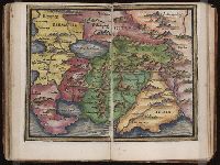
Published / Created:
[1542]
Call Number:
Taylor 86
Collection Title:
Rvdimenta cosmographica
Image Count:
1
Subject (Geographic):
Africa, Arab countries, and Middle East
Subject (Topic):
Cosmography, Early maps, and Geography, Medieval
Collection Created:
Impressvm in inclyta Transylvaniae Corona 1542
Found in:
Beinecke Rare Book and Manuscript Library > Africa
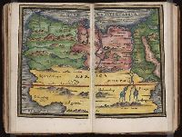
Published / Created:
[1542]
Call Number:
Taylor 86
Collection Title:
Rvdimenta cosmographica
Image Count:
1
Subject (Geographic):
Asia and India
Subject (Topic):
Cosmography, Early maps, and Geography, Medieval
Collection Created:
Impressvm in inclyta Transylvaniae Corona 1542
Found in:
Beinecke Rare Book and Manuscript Library > Asia
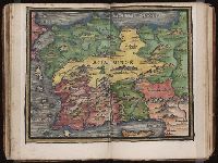
Published / Created:
[1542]
Call Number:
Taylor 86
Collection Title:
Rvdimenta cosmographica
Image Count:
1
Subject (Geographic):
Turkey
Subject (Topic):
Cosmography, Early maps, and Geography, Medieval
Collection Created:
Impressvm in inclyta Transylvaniae Corona 1542
Found in:
Beinecke Rare Book and Manuscript Library > Asia Minor
Branch:v1.61.8 ,Deployed:2024-06-20T11:14:48-04:00