Skip to search
Skip to main content
Skip to first result
Search
You Searched For
Format
cartographic
New Search
Search Results
Published / Created:
[1893?]
Call Number:
6413fb B87 1893
Container / Volume:
BRBL_00338
Image Count:
1
Resource Type:
Maps, Atlases & Globes
Alternative Title:
Bulawayo Township
Publisher:
Platnauer's, stationer and news agent,
Subject (Geographic):
Bulawayo (Zimbabwe)--Maps
Subject (Topic):
Church buildings--Zimbabwe--Bulawayo--Maps and Synagogues--Zimbabwe--Bulawayo--Maps
Found in:
Beinecke Rare Book and Manuscript Library > General plan of Bulawayo Township [cartographic material].
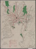
Published / Created:
1915
Call Number:
766 N46 1915
Container / Volume:
BRBL_00473A
Image Count:
1
Resource Type:
Maps, Atlases & Globes
Description:
Distance from center of city up to 5 mi. indicated by concentric rings spaced at half mile intervals., Indexes: 1. Principal parks. 2.Car lines from center of city., and Lithographed map colored to show parks and car line; blocks in outline.
Publisher:
Park Dept. City of New Haven ,
Subject (Geographic):
New Haven (Conn)--Maps
Found in:
Beinecke Rare Book and Manuscript Library > General plan of park system New Haven, Conn.
Published / Created:
[1880?].
Call Number:
75gme 1880M
Container / Volume:
BRBL_00413
Image Count:
1
Resource Type:
Maps, Atlases & Globes
Description:
Insets: Vicinity of Boston ; Vicinity of New York and Philadelphia.
Publisher:
Rand McNally & Co.,
Subject (Geographic):
United States--Maps
Found in:
Beinecke Rare Book and Manuscript Library > General railroad map of the United States and Canada, showing the Macon & Brunswick Railroad and its connections.
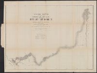
Creator:
Published / Created:
1859?]
Call Number:
89 1866G
Container / Volume:
BRBL_00658
Image Count:
1
Resource Type:
Maps, Atlases & Globes
Description:
Includes table of "Astronomical determinations" and "Map of Central America showing the routes proposed for an interoceanic ship-canal." and Relief shown by hachures.
Publisher:
s.n.,
Subject (Geographic):
Atrato River Region (Colombia)--Maps and Truandó River Region (Colombia)--Maps
Subject (Name):
United States. Army. Corps of Topographical Engineers
Subject (Topic):
Hydrographic surveying--Colombia--Atrato River Region--Maps and Hydrographic surveying--Colombia--Truandó River Region--Maps
Found in:
Beinecke Rare Book and Manuscript Library > General sketch of the survey for an interoceanic ship canal near the Isthmus of Darien via the Rivers Atrato and Truandó / made in accordance with the Act of Congress of March 3rd, 1857, under the direction of the Hon. Secretaries of War and of the Navy
Published / Created:
1825
Call Number:
54 1825
Container / Volume:
BRBL_00290
Image Count:
2
Resource Type:
Maps, Atlases & Globes
Description:
Hand Colored.
Subject (Geographic):
Tatarstan (Russia)--Maps
Found in:
Beinecke Rare Book and Manuscript Library > General'naia karta Aziiatskoi Rossii ...
Published / Created:
1848
Call Number:
41 IL6 1848
Container / Volume:
BRBL_00242
Image Count:
2
Resource Type:
Maps, Atlases & Globes
Description:
Insets: Trieste, Ljubljana, and table of data.
Publisher:
Ataria & Comp.,
Subject (Geographic):
Balkan Peninsula--Maps, Ljubljana (Slovenia)--Maps, and Trieste (Italy)--Maps
Found in:
Beinecke Rare Book and Manuscript Library > General- Post- & Strassenkarte des Königreichs Illyrien ... / gezeichnet von R.A. Schulz ; gestochen v. Domik. Biller.
Published / Created:
1842
Call Number:
41 IL6 1842
Container / Volume:
BRBL_00242
Image Count:
1
Resource Type:
Maps, Atlases & Globes
Description:
Insets: Trieste, Ljubljana, and table of data.
Publisher:
Ataria & Comp.,
Subject (Geographic):
Balkan Peninsula--Maps, Ljubljana (Slovenia)--Maps, and Trieste (Italy)--Maps
Found in:
Beinecke Rare Book and Manuscript Library > General- Post- & Strassenkarte des Königreichs Illyrien ... / gezeichnet von R.A. Schulz.
Published / Created:
1806
Call Number:
23 1806
Container / Volume:
BRBL_00020
Image Count:
1
Resource Type:
Maps, Atlases & Globes
Description:
Preliminary record.
Publisher:
Geograph. Instituts,
Subject (Geographic):
Oceania--Maps
Found in:
Beinecke Rare Book and Manuscript Library > General-Charte Von Australien ... Von J.C.M. Reinecke.
Published / Created:
1802
Call Number:
40 1802B
Container / Volume:
BRBL_00199
Image Count:
1
Resource Type:
Maps, Atlases & Globes
Publisher:
Im Verlage des Landes-Industrie Comptoirs ... ,
Subject (Geographic):
Italy--Maps
Found in:
Beinecke Rare Book and Manuscript Library > General-Charte von Italien ...
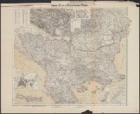
Creator:
Published / Created:
[1877?]
Call Number:
44 1877
Container / Volume:
BRBL_00255
Image Count:
1
Resource Type:
Maps, Atlases & Globes
Description:
Insets: Montenegro -- Kirid oder Kandia (Kreta) -- [Konstantinopel] -- [Konstantinopel und Umgebung] -- Bahr Sefid Baghasi (Daradanellen Strasse) -- [Continuation of main map]. and Relief shown by hachures and spot heights.
Publisher:
C. Flemming,
Subject (Geographic):
Balkan Peninsula--Maps
Subject (Name):
Carl Flemming (Firm)
Found in:
Beinecke Rare Book and Manuscript Library > General-Karte der Europäischen Türkei [cartographic material] / entw. u. gez. v. F. Handtke.
Branch:v1.61.6 ,Deployed:2024-06-12T09:55:36-04:00