Skip to search
Skip to main content
Skip to first result
Search
You Searched For
Resource Type
Maps, Atlases & Globes
Publication Place
London :
New Search
Search Results
Published / Created:
1794
Call Number:
755 1794D
Container / Volume:
BRBL_00436
Image Count:
1
Resource Type:
Maps, Atlases & Globes
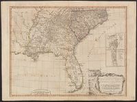
Description:
Insets: Charlestown and St. Augustine.
Publisher:
Laurie & Whittle,
Subject (Geographic):
East (U.S)--Maps--Early works to 1800
Found in:
Beinecke Rare Book and Manuscript Library > A new and general map of the Southern dominions belonging to the United States of America, ... Indian countries, and the Spanish Possessions of Louisiana and Florida.
Published / Created:
1794
Call Number:
755 1794
Container / Volume:
BRBL_00436
Image Count:
1
Resource Type:
Maps, Atlases & Globes
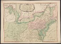
Description:
Inset: Showing the rest of the Great Lakes.
Publisher:
Laurie & Whittle,
Subject (Geographic):
Canada--Maps--Early works to 1800 and East (U.S.)--Maps--Early works to 1800
Found in:
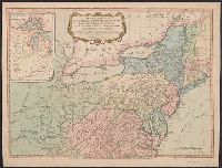
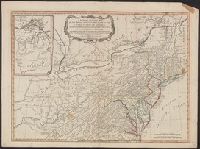
Beinecke Rare Book and Manuscript Library > A new and general map of the middle dominions belonging to the United States of America, ...
Published / Created:
1794
Call Number:
755 1794
Container / Volume:
BRBL_00436
Image Count:
1
Resource Type:
Maps, Atlases & Globes
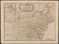
Description:
Inset: Showing the rest of the Great Lakes.
Publisher:
Laurie & Whittle,
Subject (Geographic):
Canada--Maps--Early works to 1800 and East (U.S.)--Maps--Early works to 1800
Found in:
Beinecke Rare Book and Manuscript Library > A new and general map of the middle dominions belonging to the United States of America, ...
Published / Created:
1794
Call Number:
755 1794
Container / Volume:
BRBL_00436
Image Count:
1
Resource Type:
Maps, Atlases & Globes
Description:
Inset: Showing the rest of the Great Lakes.
Publisher:
Laurie & Whittle,
Subject (Geographic):
Canada--Maps--Early works to 1800 and East (U.S.)--Maps--Early works to 1800
Found in:
Beinecke Rare Book and Manuscript Library > A new and general map of the middle dominions belonging to the United States of America, ...
Published / Created:
1794
Call Number:
755 1794
Container / Volume:
BRBL_00728
Image Count:
1
Resource Type:
Maps, Atlases & Globes
Description:
Inset: Showing the rest of the Great Lakes.
Publisher:
Laurie & Whittle,
Subject (Geographic):
Canada--Maps--Early works to 1800 and East (U.S.)--Maps--Early works to 1800
Found in:
Beinecke Rare Book and Manuscript Library > A new and general map of the middle dominions belonging to the United States of America, ...
Published / Created:
1794
Call Number:
755 1794A
Container / Volume:
BRBL_00436
Image Count:
1
Resource Type:
Maps, Atlases & Globes
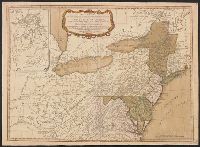
Description:
Cf. Stevens, Henry N. "Lewis Evans. His Map of the Middle British Colonies in America", London, 1920.
Publisher:
Laurie & Wittle,
Subject (Geographic):
Canada--Maps--Early works to 1800 and East (U.S.)--Maps--Early works to 1800
Found in:
Beinecke Rare Book and Manuscript Library > A new and general map of the middle dominions belonging to the United States of America, viz. Virginia, Maryland, the Delaware-Counties, Pennsylvania, New Jersey &c., with the addition of New York, & of the greatest part of New England &c. as also of the
Published / Created:
1802
Call Number:
907cea 1802
Container / Volume:
BRBL_00668
Image Count:
1
Resource Type:
Maps, Atlases & Globes
Description:
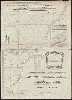
From Wittle, J. and Laurie, R.H., The West India Atlas, London, 1818. and Saililng chart showing anchorages, appearance of shore, ect., depths in fathoms, shoals rocks. "Norfork's Track 1801." Forts and settlement of Paramarabo, upstream. North at bottom.
Publisher:
Laurie & Wittle,
Subject (Geographic):
Guyana--Maps
Found in:
Beinecke Rare Book and Manuscript Library > A new chart of Surinam river (and the coast approaching it) to Paramarabo. Accompanied with sailing directions - views of the land, &c. - 1801.
Published / Created:
1827
Call Number:
85cea 1842
Container / Volume:
BRBL_00639
Image Count:
1
Resource Type:
Maps, Atlases & Globes
Description:
Eng. by J. Stephenson.
Publisher:
J.W. Norie & Co.,
Subject (Geographic):
West Indies--Maps
Found in:
Beinecke Rare Book and Manuscript Library > A new chart of the Caribbean Isles ... from Porto Rico to Trinidad ...
Published / Created:
[1760?]
Call Number:
3211cea 1760
Container / Volume:
BRBL_00055
Image Count:
1
Resource Type:
Maps, Atlases & Globes
Publisher:
Richard Mount and Thomas Page,
Subject (Geographic):
English Channel--Maps--Early works to 1800
Found in:
Beinecke Rare Book and Manuscript Library > A new chart of the Channell between England and France.
Published / Created:
1794
Call Number:
60cea 1794
Container / Volume:
BRBL_00329
Image Count:
1
Resource Type:
Maps, Atlases & Globes
Description:
Inset: Bay & Town of Mogadore. Ca. 1:20,000.
Publisher:
Laurie & Whittle,
Subject (Geographic):
Africa--Maps--Early works to 1800
Found in:
Beinecke Rare Book and Manuscript Library > A new chart of the Coast of Africa from the Straits of Gibralter to Cape Blanco with Madeira & the Canary Islands ...
Branch:v1.61.6 ,Deployed:2024-06-12T09:55:36-04:00