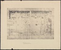
A photomechanical print probably created during the early twentieth century as a forgery that reproduces twelve gores for a globe published in 1507 by Martin Waldseemüller based on his wall map, Universalis Cosmographia (1507). and Evidence of the forgery includes the superimposition of the gores over glue already on the paper surface, which suggests use of a sheet removed from a period volume, as well as details that replicate gores from an authentic woodcut print formerly owned by Austrian cartographer Franz Hauslab and acquired by the James Ford Bell Library at the University of Minnesota in 1954
Description:
A gore is a roughly triangular or wedge-shaped segment of an object, as found in domes and globes, where a sector of a curved surface, or a curved surface that lies between two close lines of longitude on a globe, and flattened to a plane surface with little distortion., Martin Waldseemüller (1470-1519) was a German cartographer. His wall map Universalis Cosmographia (1507) and printed globes contemporarily derived from it were the first published globular maps of the Western Hemisphere and the first maps on which the name America appears in honor of Italian explorer Amerigo Vespucci (1454-1512)., In Latin., Title devised by cataloger., and Publication place and date of creation supplied by the cataloger.
Subject (Geographic):
America
Subject (Name):
Hauslab, Franz, 1798-1883., Vespucci, Amerigo, 1451-1512., and Waldseemüller, Martin, 1470-1519
Subject (Topic):
Forgeries, Globes, World maps, Discovery and exploration, and Name
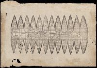
Cross Collection no. 60., From Janssonius's Niewen atlas ... Amstelodami : Apud Ioannem Ianssonium, 1652., Hand col. Mounted on linen., Includes marginal ill., Relief shown pictorially., Title supplied by cataloger., and Variant of Hondius' Polus Antarcticus, 1638.
Publisher:
J. Jansson,
Subject (Geographic):
Antarctica--Maps--Early works to 1800 and Southern Hemisphere--Maps--Early works to 1800
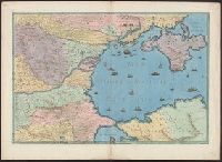
Title devised by cataloger., "Vinc[enti]us demetrei Volcius Rachuseus. Fecit interra Liiburni die 24 Maius 1601.", With blue cloth tie at left edge., Color: red, blue, and some gold., With four compass roses., and Coordinates not present on map and are approximated.
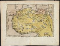
Cordiform projection., From: "Claudii Ptholemaei Alexandrini liber geographiae cum tabulis...", From: Clavdii Ptholemaei Alexandrini Liber geographiae cvm tabvlis...1511., Lanman collection; dgvmp2008., Map is printed in two colors, red and black., Outer map border shows decorative windheads and zodiacal signs., The author's name is often given as Bernard Sylvanus (see Shirley entry 32, plate 35) or Bernardus Sylvanus., and Title supplied by cataloger.
Publisher:
Per Iacobum Pentium de Leucho,
Subject (Name):
Pencio, Jacopo, active 1486-1530 and Ptolemy, active 2nd century. Geographia