Appears in Schenk's Atlas contractus [ca. 1700]., Bar scales in milliaria Germanica communia, milliaria Gallica sive horae itineris, milliaria Italia, and milliaria Anglica., Ferro meridian., Includes decorative vignette in upper left of map., No. 48 of 69 maps bound together in composite atlas., Relief shown pictorially., and Scale [ca. 1:330 000].
Publisher:
[Peter Schenck]
Subject (Geographic):
Belgium --Maps --Early works to 1800 and Flanders --Maps --Early works to 1800
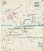
Sanborn fire insurance maps are a rich source of historic data on the urban built environment of North America during the 19th and early 20th centuries. The atlases were created for the purpose of underwriting fire insurance policies, which depended upon accurate and frequently-updated information about construction materials, municipal and transportation infrastructure, industrial and commercial landuse and more. The Yale University Library Map Department scanned its holdings of Sanborn fire insurance maps (consisting primarily of Connecticut towns) in order to make the maps more accessible.
Alternative Title:
June 1884, Forestville, Conn.
Description:
"2 sheets.", Contains information on population, prevailing winds, water facilities and fire department., Partial cadastral map., and SMLMAPL 766 F76 1884: Sheets disbound. "Triplicate" stamp on both sheets. Library of Congress copyright stamp on title sheet.
Subject (Geographic):
Forestville (Conn.)--Maps
Subject (Name):
Library of Congress Stamp
Subject (Topic):
Fire risk assessment--Connecticut--Forestville--Maps and Real property--Connecticut--Forestville--Maps
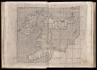
For fuller description see collation slip in volume. and Imperfect: fol. 116 (blank) wanting.
Publisher:
Nicolaus Laurentii, Alamanus,
Subject (Geographic):
Corsica (France)--Maps--Early works to 1800, England--Maps--Early works to 1800, Ireland--Maps--Early works to 1800, Italy--Maps--Early works to 1800, and Sardinia (Italy)--Maps--Early works to 1800
Sanborn fire insurance maps are a rich source of historic data on the urban built environment of North America during the 19th and early 20th centuries. The atlases were created for the purpose of underwriting fire insurance policies, which depended upon accurate and frequently-updated information about construction materials, municipal and transportation infrastructure, industrial and commercial landuse and more. The Yale University Library Map Department scanned its holdings of Sanborn fire insurance maps (consisting primarily of Connecticut towns) in order to make the maps more accessible.
Alternative Title:
Jan. 1928, Glastonbury, Conn.
Description:
"(3445) (8 sheets).", Contains information on population, prevailing winds, water facilities and fire department., Includes index of streets and specials., Partial cadastral map., Sheets 5-8 at scale 1:600; Sheets 1-4 at scale 1:1,200., and SMLMAPL 766 G46 1928: Sheets disbound. Library of Congress copyright stamp on title sheet.
Subject (Geographic):
Glastonbury (Conn.)--Maps
Subject (Name):
Library of Congress Stamp
Subject (Topic):
Fire risk assessment--Connecticut--Glastonbury--Maps and Real property--Connecticut--Glastonbury--Maps
Bar scales given in mill. Germanica sive geometrica 15 in uno gradu and milliaria Gallica magna sive horae itineris., No. 14 of 69 maps bound together in composite atlas., Relief shown pictorially., and Scale [ca. 1:680 000].
Bar scales given in Italian miles and com[m]on leagues of France., I. Harris, sc., Longitude east from London., No. 18 of 69 maps bound together in composite atlas., Relief shown pictorially., and Scale [ca. 1:2 300 000].
Publisher:
Improved and sold by Robt. Morden and Christopr. Browne at the Atlas in Cornhill and the Globe ye Westend of St. Pauls
Subject (Geographic):
Italy --History --1559-1789 --Maps and Italy --Maps --Early works to 1800
Sanborn fire insurance maps are a rich source of historic data on the urban built environment of North America during the 19th and early 20th centuries. The atlases were created for the purpose of underwriting fire insurance policies, which depended upon accurate and frequently-updated information about construction materials, municipal and transportation infrastructure, industrial and commercial landuse and more. The Yale University Library Map Department scanned its holdings of Sanborn fire insurance maps (consisting primarily of Connecticut towns) in order to make the maps more accessible.
Description:
Contains information on population, prevailing winds, water facilities and fire department., Partial cadastral map., SMLMAPL 766 H26 1885: Sheets disbound. "Triplicate" stamp on all sheets. Library of Congress copyright stamp on title sheet., and The unnumumbered leaves are the title sheet and index sheet.
Subject (Geographic):
Hartford (Conn.)--Maps
Subject (Name):
Library of Congress Stamp
Subject (Topic):
Fire risk assessment--Connecticut--Hartford--Maps and Real property--Connecticut--Hartford--Maps
Sanborn fire insurance maps are a rich source of historic data on the urban built environment of North America during the 19th and early 20th centuries. The atlases were created for the purpose of underwriting fire insurance policies, which depended upon accurate and frequently-updated information about construction materials, municipal and transportation infrastructure, industrial and commercial landuse and more. The Yale University Library Map Department scanned its holdings of Sanborn fire insurance maps (consisting primarily of Connecticut towns) in order to make the maps more accessible.
Alternative Title:
Feb. 1901, Higganum, Conn.
Description:
"2 sheets. 4507.", "Town of Haddam.", Contains information on population, prevailing winds, water facilities and fire department., Partial cadastral map., and SMLMAPL 766 H53 1901: Sheets disbound. "Triplicate" stamp on both sheets. Library of Congress copyright stamp on title sheet.
Subject (Geographic):
Higganum (Conn.)--Maps
Subject (Name):
Library of Congress Stamp
Subject (Topic):
Fire risk assessment--Connecticut--Higganum--Maps and Real property--Connecticut--Higganum--Maps
Sanborn fire insurance maps are a rich source of historic data on the urban built environment of North America during the 19th and early 20th centuries. The atlases were created for the purpose of underwriting fire insurance policies, which depended upon accurate and frequently-updated information about construction materials, municipal and transportation infrastructure, industrial and commercial landuse and more. The Yale University Library Map Department scanned its holdings of Sanborn fire insurance maps (consisting primarily of Connecticut towns) in order to make the maps more accessible.
Alternative Title:
Mar. 1908, Higganum, Conn.
Description:
"2 sheets. 162.", "Town of Haddam.", Contains information on population, prevailing winds, water facilities and fire department., Partial cadastral map., and SMLMAPL 766 H53 1908: Sheets disbound. "Triplicate" stamp on both sheets. Library of Congress copyright and Map Division stamps on title sheet.
Subject (Geographic):
Higganum (Conn.)--Maps
Subject (Name):
Library of Congress Stamp and Library of Congress. Map Division Stamp
Subject (Topic):
Fire risk assessment--Connecticut--Higganum--Maps and Real property--Connecticut--Higganum--Maps
Sanborn fire insurance maps are a rich source of historic data on the urban built environment of North America during the 19th and early 20th centuries. The atlases were created for the purpose of underwriting fire insurance policies, which depended upon accurate and frequently-updated information about construction materials, municipal and transportation infrastructure, industrial and commercial landuse and more. The Yale University Library Map Department scanned its holdings of Sanborn fire insurance maps (consisting primarily of Connecticut towns) in order to make the maps more accessible.
Alternative Title:
Mar. 1914, Higganum, Conn.
Description:
"6712 (3 sheets).", "Town of Haddam.", Contains information on population, prevailing winds, water facilities and fire department., Includes index of specials., Partial cadastral map., and SMLMAPL 766 H53 1914: Sheets disbound. Library of Congress copyright stamp on title sheet.
Subject (Geographic):
Higganum (Conn.)--Maps
Subject (Name):
Library of Congress Stamp
Subject (Topic):
Fire risk assessment--Connecticut--Higganum--Maps and Real property--Connecticut--Higganum--Maps