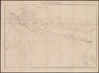
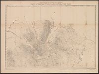
Geological and Geographical Survey of the Territories (U.S.)
Published / Created:
[1878]
Call Number:
833 1878
Container / Volume:
BRBL_00584
Image Count:
1
Resource Type:
Maps, Atlases & Globes
Description:
"45"--Lower right margin., "9"--Upper left margin., "Surveyed in 1877 & 78.", Relief shown by contours and spot heights., and To accompany the Survey's 12th annual report (1878).
Publisher:
Julius Bien, Lith., and The Survey] ;
Subject (Geographic):
Idaho--Maps and Wyoming--Maps
Subject (Name):
Bechler, G. R, Clark, Fred A, and Hayden, F. V. (Ferdinand Vandeveer), 1829-1887
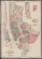
Topographical map of the cities of New York, Brooklyn, Jersey City and Hoboken
Description:
Hand colored., Insets: New York County north of 150th St. -- Map of New Neth, and Shows wards, other unspecified districts, ferry lines, some buildings and topographical details of surrounding islands, and parts of Queens County and New Jersey north of Hoboken.
Publisher:
M. Dripps,
Subject (Geographic):
Brooklyn (New York, N.Y.)--Administrative and political divisions--Maps, Brooklyn (New York, N.Y.)--Maps, Hoboken (N.J.)--Maps, Jersey City (N.J.)--, and New York (N.Y.)--Administrative and political divisions--Maps