Skip to search
Skip to main content
Skip to first result
Search
You Searched For
Format
cartographic
Genre
Marginalia
New Search
Search Results
Creator:
Published / Created:
1750
Call Number:
1973 Folio 30
Collection Title:
[Atlas factice of 32 maps and 1 distance table, produced by the Homann Erben firm]
Image Count:
2
Publisher:
[Matthaeus Seutter?]
Subject (Geographic):
Nordhausen (Germany : Landkreis) --Maps --Early works to 1800
Subject (Topic):
Atlases, German --Early works to 1800
Collection Created:
[Nuremberg : s.n., 1701-1760]
Found in:
Beinecke Rare Book and Manuscript Library > Comitatus Stolbergensis delineatio geographia, Praefecturas Hohnstein, Stolberg, Hayn Berenroda, Ebersburg, Ufftrungen, Rosla et Questen cum limitibus et vicinia accurate exhibens / [cartographic material] / caelo Matthaei Seutteri. Georgraphi Caesarei ;
Call Number:
1983 Folio 19
Collection Title:
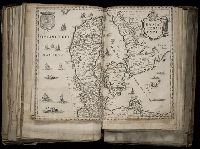
[Atlas factice of 96 maps by Blaeu, Visscher, Jansson, Hondius and others]
Image Count:
2
Description:
Imperfect: lower left corner [imprint] cut-out and replaced with ms. ill.; edges reinforced with ms waste. Sheet measures 38.5 x 48.9 cm. No. 67 of 92 maps bound together. and Numbered 72 on verso.
Subject (Geographic):
Denmark --Maps --Early works to 1800
Subject (Topic):
Atlases --Early works to 1800
Collection Created:
[1556-1680]
Found in:
Beinecke Rare Book and Manuscript Library > Daniae regni typus
Creator:
Published / Created:
1750
Call Number:
1973 Folio 30
Collection Title:
[Atlas factice of 32 maps and 1 distance table, produced by the Homann Erben firm]
Image Count:
2
Publisher:
[Matthaeus Seutter?]
Subject (Geographic):
Saxony-Anhalt (Germany) --Maps --Early works to 1800
Subject (Topic):
Atlases, German --Early works to 1800
Collection Created:
[Nuremberg : s.n., 1701-1760]
Found in:
Beinecke Rare Book and Manuscript Library > Delineatio geographica comitatus Mansfeldensis ad jurisdictionem tum Saxonicam tum Brandenburgicam spectans, cum praefectura Sangerhusana, Querfurtensi, Sittenbacensi, Allstaedensi, et loci finitimis / [cartographic material] / cura Matth. Seutteri, Geogr
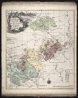
Creator:
Published / Created:
ca. 1750
Call Number:
1973 Folio 30
Collection Title:
[Atlas factice of 32 maps and 1 distance table, produced by the Homann Erben firm]
Image Count:
2
Publisher:
[Tobias Conrad Lotter?]
Subject (Geographic):
Chemnitz (Germany : Landkreis) --Maps --Early works to 1800 and Zwickau (Germany : Landkreis) --Maps --Early works to 1800
Subject (Topic):
Atlases, German --Early works to 1800
Collection Created:
[Nuremberg : s.n., 1701-1760]
Found in:
Beinecke Rare Book and Manuscript Library > Dynastiae comitat[us] Schoenbuirgici Penig, Remissa, Rochsburg, Wechselburg [cartographic material] : in clientela Elect. Saxon Glaucha, Hartenstein, Lichtenst. Stein, Waldenburg Praedia Benefic. S.R. Imp. ad circulum S.R.I. Saxoniae superiorem pertinente
Creator:
Published / Created:
ca. 1757
Call Number:
1973 Folio 30
Collection Title:
[Atlas factice of 32 maps and 1 distance table, produced by the Homann Erben firm]
Image Count:
2
Publisher:
[Tobias Conrad Lotter]
Subject (Geographic):
Saxony (Germany) --Maps --Early works to 1800
Subject (Topic):
Atlases, German --Early works to 1800
Collection Created:
[Nuremberg : s.n., 1701-1760]
Found in:
Beinecke Rare Book and Manuscript Library > Electoratus Saxonici Praefecturae Annaburgensis, Pretzschens[is] Torgaviensis, Schweinicensis, Muehlbergensis studio geographico / [cartographic material] / ita depictae, ut urbes, oppida, vici, pagi, aedes solitar cum vicinia accurate distingui possint a
Branch:v1.64.0 ,Deployed:2024-09-11T10:25:34-04:00