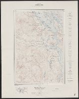
Map (Geological Survey of Canada) ; 41A. and Map ; 41A
Description:
Includes location map., Relief shown by contours and spot heights., and Shows roads, buildings, trails, railways, tramways, prospects, lighthouses, etc.
Publisher:
Canada Dept. of Mines, Geological Survey,
Subject (Geographic):
Duncan Region (B.C.)--Maps and Vancouver Island (B.C.)--Maps
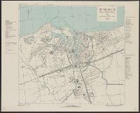
France 1:10,000, Geographical Section, General Staff ; no. 4234, and GSGS (Series) ; 4234.
Description:
"8-43.", "AMS 2.", "Grid provisional, Nord de Guerre zone grid.", "War Office 1943.", Important streets are named; list of important buildings, industries and port facilities in margin., and Major streets and buildings in French.
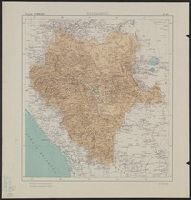
Mexico. Dirección de Estudios Geográficos y Climatológicos
Published / Created:
[1922]
Call Number:
8813 1922
Container / Volume:
BRBL_00650
Image Count:
2
Resource Type:
Maps, Atlases & Globes
Description:
"No. 10.", Accompanied by physiographic plate covering same area, showingonly relief and drainage (1 sheet : col. ; 59 cm.)., Appears in Atlas geográfico de la República Mexicana., and Relief shown by shading. Depths shown by isolines.
Publisher:
La Dirección,
Subject (Geographic):
Durango (Mexico : State)--Maps
Subject (Name):
Mexico. Dirección de Estudios Geográficos y Climatológicos. Atlas geográfico de la República Mexicana
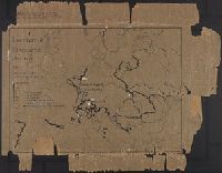
"From: Political Science Quarterly, Vol. XXXIX, No. 3, September 1924, p. 460-461.", Imperfect, ms. writing., and Key: Thickness of line indicating duration.