Skip to search
Skip to main content
Skip to first result
Search
You Searched For
Repository
Beinecke Rare Book and Manuscript Library
Genre
Maps
Language
Italian
New Search
Search Results
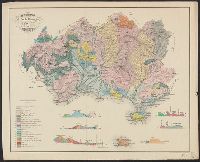
Published / Created:
[1860?]
Call Number:
40CA G914 1860
Container / Volume:
BRBL_00228
Image Count:
1
Resource Type:
Maps, Atlases & Globes
Publisher:
Lit. di Ach. Paris,
Subject (Geographic):
Grosseto (Italy : Province)--Maps
Found in:
Beinecke Rare Book and Manuscript Library > Abbozzo di carta geologica della provincia di Grossetto.
Creator:
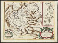
Published / Created:
[1695?]
Call Number:
62 1695
Container / Volume:
BRBL_00333
Image Count:
1
Resource Type:
Maps, Atlases & Globes
Alternative Title:
Abissinia, dove sono le fonti del Nilo
Description:
"Dedicata all'. illmo. et eccmo. sig. Michele Foscarini, sauio grande e storiografo della seren. Rep. di Venetia.", Appears in Coronelli's Atlante veneto., Hand col. Sheet measures 49 x 67 cm. dgvmp2008., and Inset: Origine, e corso del Nilo, descrito secondo l'
Publisher:
Si uende presso Dom. Padoani sul ponte di Rialto all' Insegna della Geografia,
Subject (Geographic):
Ethiopia--Maps--Early works to 1800 and Nile River--Discovery and exploration--Maps--Early works to 1800
Subject (Name):
Coronelli, Vincenzo, 1650-1718. Atlante veneto, Foscarini, Michele, 1632-1692, and Padoani, Domenico
Found in:
Beinecke Rare Book and Manuscript Library > Abissinia, doue sono le fonti del Nilo : descritta secondo le relationi de P.P. Mendez, Almeida, Païs, Lobo, e Lodulfo / del P.M. Coronelli M.C. cosmografo della seren. Rep. di Venetia
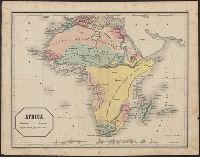
Published / Created:
1851
Call Number:
60 1851
Container / Volume:
BRBL_00326
Image Count:
1
Resource Type:
Maps, Atlases & Globes
Publisher:
Lit. Frlli Doyen e Cia,
Subject (Geographic):
Africa--Maps
Subject (Name):
Doyen & Compagnia and Richetti, G., 18..-18.. egr
Found in:
Beinecke Rare Book and Manuscript Library > Africa / G. Richetti , editore.
Creator:
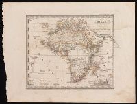
Published / Created:
[1855]
Call Number:
BrSides 2019 70
Image Count:
1
Resource Type:
Maps, Atlases & Globes
Description:
In upper right corner: Atlante scol. di Stieler, No. XVIII., Prime meridian: Ferro., and Relief shown pictorially.
Publisher:
Giusto Perthes,
Subject (Geographic):
Africa--Maps
Subject (Name):
Justus Perthes (Firm : Gotha, Germany), publisher, Münster, H. F., publisher, and Stieler, Adolf, 1775-1836. Kleiner Schulatlas über alle Theile der Erde. Italian.
Found in:
Beinecke Rare Book and Manuscript Library > Africa : secondo le più nuove scoperte / corretta da Erm. Berghaus.
Creator:
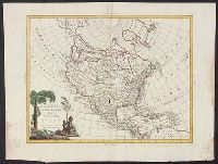
Published / Created:
1688
Call Number:
71 1688
Container / Volume:
BRBL_00360
Image Count:
2
Resource Type:
Maps, Atlases & Globes
Description:
Appears in his Atlante veneto ... Venetia : a' spese dell' autore, 1695-1697., Prime meridian: Ferro., Relief shown pictorially., and Yale's copy 2 missing western sheet; also stamped "Yale, Horace Brown, 1900S." dgvmp2008.
Publisher:
a' spese dell' autore],
Subject (Geographic):
North America--Maps--Early works to 1800
Found in:
Beinecke Rare Book and Manuscript Library > America Settentrionale : colle nuoue scoperte fin all' anno 1688 / ... descritta dal P. Mro Coronelli M.C. cosmografo della serenisma Repubca. di Venezia.
Creator:
Published / Created:
1688
Call Number:
71 1688
Container / Volume:
BRBL_00360
Image Count:
1
Resource Type:
Maps, Atlases & Globes
Description:
Appears in his Atlante veneto ... Venetia : a' spese dell' autore, 1695-1697., Prime meridian: Ferro., Relief shown pictorially., and Yale's copy 2 missing western sheet; also stamped "Yale, Horace Brown, 1900S." dgvmp2008.
Publisher:
a' spese dell' autore],
Subject (Geographic):
North America--Maps--Early works to 1800
Found in:
Beinecke Rare Book and Manuscript Library > America Settentrionale : colle nuoue scoperte fin all' anno 1688 / ... descritta dal P. Mro Coronelli M.C. cosmografo della serenisma Repubca. di Venezia.
Creator:
Published / Created:
[1766?]
Call Number:
71 1766
Container / Volume:
BRBL_00364
Image Count:
1
Resource Type:
Maps, Atlases & Globes
Description:
Relief shown pictorially. and Yale's copy stamped on backing: Yale University Library, Karpinski-Von Wieser Map Collection.
Publisher:
a spese di Paolo Petrini et da lui si vendono in Napoli a S. Biaggio de Librari,
Subject (Geographic):
North America--Maps--Early works to 1800
Subject (Name):
Donzel, Anton and Sanson, Nicolas, 1600-1667
Found in:
Beinecke Rare Book and Manuscript Library > America settentrionale : dedicata allèccell, sig. principe d'Auellino etc. ... corretta, et aumentata, secondo le relatione più moderne / da N. Sanson d'Abbeuile giografo di sua Maestà Christma. làn 1766 in Pariggi ; Antonius Donzel Gallus sculpsit.
Creator:
Published / Created:
[1785?]
Call Number:
71 1785B
Container / Volume:
BRBL_00366
Image Count:
1
Resource Type:
Maps, Atlases & Globes
Description:
Appears in Antonio Zatta's Atlante novissimo. and Relief shown pictorially.
Publisher:
Presso Antonio Zatta, e Figli,
Subject (Geographic):
North America--Maps--Early works to 1800
Subject (Name):
Zatta, Antonio, fl. 1757-1797. Atlante novissimo
Found in:
Beinecke Rare Book and Manuscript Library > America settentrionale divisa ne' suoi principali stati.
Creator:
Published / Created:
1757
Call Number:
70 1757
Container / Volume:
BRBL_00724
Image Count:
1
Resource Type:
Maps, Atlases & Globes
Description:
"F. Polanzani, sculp.", Relief shown pictorially., and Sheet measures 28 x 32 cm.
Publisher:
[s.n.],
Subject (Geographic):
America--Maps--Early works to 1800 and Western Hemisphere--Maps--Early works to 1800
Subject (Name):
Neralco, 1672 or 3-1759
Found in:
Beinecke Rare Book and Manuscript Library > America settentrionale e meridionale : con tutte le sue regioni e classi d'isole secondo il novo sistema di Neralco P.A.
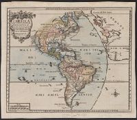
Creator:
Published / Created:
1757
Call Number:
70 1757
Container / Volume:
BRBL_00686
Image Count:
1
Resource Type:
Maps, Atlases & Globes
Description:
"F. Polanzani, sculp.", Not colored. Sheet measures 28.8 x 43.4 cm. Cross Collection no. 134., and Relief shown pictorially.
Publisher:
[s.n.],
Subject (Geographic):
America--Maps--Early works to 1800 and Western Hemisphere--Maps--Early works to 1800
Subject (Name):
Neralco, 1672 or 3-1759
Found in:
Beinecke Rare Book and Manuscript Library > America settentrionale e meridionale : con tutte le sue regioni e classi d'isole secondo il novo sistema di Neralco P.A.
Branch:v1.61.6 ,Deployed:2024-06-12T09:55:37-04:00