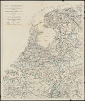
Appears on sheet Die Englische Colonie-Laender ... [Nürnberg] : Homaennische Erben, [ca. 1740], with, Cross Collection no. 282., Relief shown pictorially., and Title in Latin, explanations in German, and map locations in English.
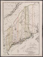
"Zu Ebelings Erdbeschreibung von America.", Also shows county boundaries., Bar scales given in "Geographische Meilen 15 auf einen Grad" and "Englische meilen 69 4/25 auf einen Grad.", Includes index to land grants., Place names in German and Englis, and Watermark.
Publisher:
Bey Carl Ernst Bohn,
Subject (Geographic):
Maine--Administrative and political divisions--Maps--Early works to 1800 and Maine--Maps--Early works to 1800
Subject (Name):
Bohn, Carl Ernst, Ebeling, Christoph Daniel,--1741-1817--Presentation inscription to N. Webster, Ebeling, Christophe Daniel, 1741-1817. Erdbeschreibung und Geschichte von Amerika, and Sander, Wilhelm, 1766-1836, engraver
"Zu Ebelings Erdbeschreibung von America.", Also shows county boundaries., In upper right margin: No. IV., Includes index to land grants., Place names in German and English., Prime meridians: Greenwich a, Relief shown by hachures., and Sheet measures 75.5 x 53.8 cm.
Publisher:
Bey Carl Ernst Bohn,
Subject (Geographic):
Maine--Administrative and political divisions--Maps--Early works to 1800 and Maine--Maps--Early works to 1800
Subject (Name):
Bohn, Carl Ernst, Ebeling, Christophe Daniel, 1741-1817. Erdbeschreibung und Geschichte von Amerika, and Sander, Wilhelm, 1766-1836, engraver
Bohn, Carl Ernst Ebeling, Christophe Daniel, 1741-1817. Erdbeschreibung und Geschichte von Amerika Sander, Wilhelm, 1766-1836, engraver Sotzmann, D. F
Published / Created:
1798
Call Number:
1977 Folio 177
Image Count:
2
Resource Type:
Maps, Atlases & Globes
Description:
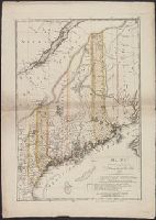
"Zu Ebelings Erdbeschreibung von America.", Also shows county boundaries., Bar scales given in "Geographische Meilen 15 auf einen Grad" and "Englische meilen 69 4/25 auf einen Grad.", In upper right margin: No. IV., Includes index to land grants., Place names in German and English., Prime meridians: Greenwich and Washington., Relief shown by hachures., Sheet measures 74.0 x 53.1 cm. Presentation inscription from C.D. Eberling to Noah Webster. No. 9 of 34 maps bound together., and Watermark.
Publisher:
Bey Carl Ernst Bohn,
Subject (Geographic):
Maine--Administrative and political divisions--Maps--Early works to 1800 and Maine--Maps--Early works to 1800
Subject (Name):
Ebeling, Christoph Daniel,--1741-1817--Presentation inscription to N. Webster and Webster, Noah,--1758-1843--Presentation inscription from C.D. Ebeling
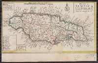
Mappa Aestivarvm insularum, alias Barmvdas dictarum
Description:
Below map, list of proprietors in 12 columns flanked by coats-of-arms., Borders are hand colored., and Not hand colored. With watermark. Sheet measures 46 x 55 cm.
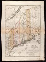
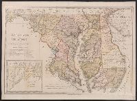
"W. Sander sculp.", "Zu Ebelings Erdbeschreibung von Amerika.", In upper right margin: No. X., Includes inset of western section of what is now Garrett and Allegany Counties., No watermark. Sheet measures 50.8 x 68.8 cm. Franklin Collection no. 131 1797-3., Place names in English and German., Prime meridians: Greenwich and Washington., Relief shown by hachures., and Watermark.
Publisher:
Bey Carl Ernst Bohn,
Subject (Geographic):
Delaware--Administrative and political divisions--Maps--Early works to 1800, Delaware--Maps--Early works to 1800, Maryland--Administrative and political divisions--Maps--Early works to 1800, and Maryland--Maps--Early works to
Subject (Name):
Bohn, Carl Ernst, Ebeling, Christophe Daniel, 1741-1817. Erdbeschreibung und Geschichte von Amerika, and Sander, Wilhelm, 1766-1836, engraver
Bohn, Carl Ernst Ebeling, Christophe Daniel, 1741-1817. Erdbeschreibung und Geschichte von Amerika Sander, Wilhelm, 1766-1836, engraver Sotzmann, D. F
Published / Created:
1797
Call Number:
1977 Folio 177
Image Count:
2
Resource Type:
Maps, Atlases & Globes
Description:
"W. Sander sculp.", "Zu Ebelings Erdbeschreibung von Amerika.", In upper right margin: No. X., Includes inset of western section of what is now Garrett and Allegany Counties., Place names in English and German., Prime meridians: Greenwich and Washington., Relief shown by hachures., Sheet measures 54.3 x 73.9 cm. No. 2 of 34 maps bound together., and Watermark.
Publisher:
Bey Carl Ernst Bohn,
Subject (Geographic):
Delaware--Administrative and political divisions--Maps--Early works to 1800, Delaware--Maps--Early works to 1800, Maryland--Administrative and political divisions--Maps--Early works to 1800, and Maryland--Maps--Early works to 1800