Lake Itasca basin, Minnesota, within Itasca State Park
Description:
" ... Topography by W.G. Comber, G.H. French and F.G. Ray. Hydrography by W.G. Comber. Office reduction, under the direction of C.W. Clark ... by A.T. Morrow, W.G. Comber, G.H. French, E.L. Harman, W.S. Williams, F.G. Ray, and Geo. H. Wolbrecht. Drawing,
Publisher:
s.n.,
Subject (Geographic):
Itasca State Park (Minn.)--Maps and Itasca, Lake (Minn.)--Maps
Subject (Name):
Clark, C. W, Comber, W. G, D'Ailly, H. A. H, French, G. H, Harmon, E. L, Julius Bien & Co, Morrow, A. T, Ray, F. G, Widen, K. A, and Williams, W. S
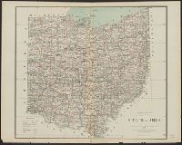
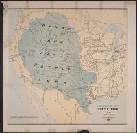
"No I.", "To accompany a report in reply to a resolution of the House of Representatives dated Feb 16th, 1885"., and Shows cattle trails, quarantine lines, "assumed northern limit of Texas fever district", railroads, cities and towns, Indian reservations, rivers, and isotherms.
Publisher:
Julius Bien & Co.,
Subject (Name):
Julius Bien & Co, Nimmo, Joseph, 1837-1909, and United States. Dept. of the Treasury. Report on the internal commerce of the United States
Subject (Topic):
Railroads--West (U.S.)--Maps and Rangelands--West (U.S.)--Maps
Includes population chart and index to ownership of electric railways., Inset: Map showing the lines of communication between New York, Boston and the West., and Relief shown by shading and spot heights.