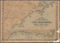
New topographical map of the eastern portion of the state of North Carolina
Description:
At upper left corner, outside margin & foliate border: No. 11., Cut into 2 sheets, Inset map: Plan of the, Prime meridans: Greenwich and Washington, D.C., Relief shown by hachures., and Shows names of counties, cities, towns, roads, railroads, rivers, and inlets.