Skip to search
Skip to main content
Skip to first result
Search
You Searched For
Resource Type
Maps, Atlases & Globes
Publication Place
Chicago :
New Search
Search Results
Creator:
Published / Created:
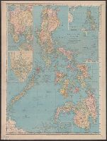
1907
Call Number:
28 1907
Container / Volume:
BRBL_00023E
Image Count:
1
Resource Type:
Maps, Atlases & Globes
Description:
Insets: Manila -- Manila to Dagupan -- Philippine Islands and the China Sea -- Batanes (Bashee) and Babuyanes Is. -- Continuation of Sulu Archipelago.
Publisher:
Rand, McNally & Co.,
Subject (Geographic):
Philippines--Maps
Found in:
Beinecke Rare Book and Manuscript Library > Philippine Islands.
Creator:
Published / Created:
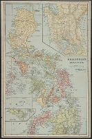
[1899?]
Call Number:
28 1900A
Container / Volume:
BRBL_00023E
Image Count:
1
Resource Type:
Maps, Atlases & Globes
Alternative Title:
Pocket map of Philippine Islands
Description:
"Compliments of Gilbert & Nichols, merchant millers, Fulton, N.Y." - Cover., Imperfect: Cover wanting., Inset maps of Manila, lower part of Mindanao and the Caroline Islands., and Relief represented by hachures and spot heights.
Publisher:
Fort Dearborn Pub. Co.,
Subject (Geographic):
Caroline Islands--Maps, Manila (Philippines)--Maps, Mindanao Island (Philippines)--Maps, and Philippines--Maps
Found in:
Beinecke Rare Book and Manuscript Library > Philippine Islands.
Published / Created:
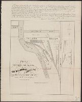
1860
Call Number:
806gme C43 1860
Container / Volume:
BRBL_00549
Image Count:
1
Resource Type:
Maps, Atlases & Globes
Description:
Description of the lot printed across top margin.
Publisher:
G.W. Clarke,
Subject (Geographic):
Illinois--Maps
Found in:
Beinecke Rare Book and Manuscript Library > Plat exhibiting the location of the Southern Michigan and Rock Island R.R. depots and adjacent grounds. / lithographed by Ed Mendel.
Creator:
Published / Created:
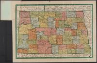
1911
Call Number:
822 1911A
Container / Volume:
BRBL_00567
Image Count:
2
Resource Type:
Maps, Atlases & Globes
Alternative Title:
Complete map of N. Dakota, showing principal automobile roads, electric lines, railroads, M.O. postoffices, banks, rivers, canals, and last U.S. census of all towns and North Dakota
Description:
1910 census gazetteer of North Dakota on verso. and Relief shown by hachures.
Publisher:
Geographical Publishing Co.,
Subject (Geographic):
North Dakota--Maps
Found in:
Beinecke Rare Book and Manuscript Library > Premier series North Dakota / edited, engraved, and published by The Geographical Publishing Co.
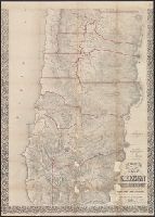
Creator:
Published / Created:
1856
Call Number:
846 1856
Image Count:
2
Resource Type:
Maps, Atlases & Globes
Alternative Title:
Preston's map of Oregon & Washington Territories, 1856
Description:
"Entered according to act of Congress in the year 1856, J.A. Preston, in the clerk's office of the district court of the United States, for the northern district of Illinois." and Library's copy 1 in case 19 x 13 cm. Copy 2 without covers, and dissected and mounted on linen, in 2 sheets (84 x 60 cm. and 79 x 60 cm.)
Publisher:
A.H. Burley, Stationer,
Subject (Geographic):
Oregon--Maps and Washington (State)--Maps
Subject (Name):
Burley, A. H, Ferd. Mayer & Co, Hyde, G. W, and Preston, J. A. (John A.)
Found in:
Beinecke Rare Book and Manuscript Library > Preston's sectional and county map of Oregon and Washington : west of the Cascade mountains / compiled ... by J.W. Trutch and G.W. Hyde.
Creator:
Published / Created:
c1904.
Call Number:
734 1904
Container / Volume:
BRBL_00379
Image Count:
1
Resource Type:
Maps, Atlases & Globes
Alternative Title:
The Rand McNally new business atlas map of Quebec
Description:
Includes indexes to railroads and principal cities. and Inset: North eastern portion of Quebec -- Western portion of Quebec.
Publisher:
Rand McNally & Co.,
Subject (Geographic):
Québec (Province)--Maps
Subject (Topic):
Railroads--Québec (Province)--Maps and Roads--Québec (Province)--Maps
Found in:
Beinecke Rare Book and Manuscript Library > Quebec / Rand McNally and Company.
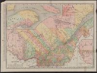
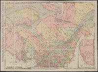
Creator:
Published / Created:
c1909.
Call Number:
734 1909
Container / Volume:
BRBL_00379
Image Count:
1
Resource Type:
Maps, Atlases & Globes
Alternative Title:
The Rand McNally new business atlas map of Quebec
Description:
Includes indexes to railroads and principal cities. and Inset: North eastern portion of Quebec -- Western portion of Quebec.
Publisher:
Rand McNally & Co.,
Subject (Geographic):
Québec (Province)--Maps
Subject (Topic):
Railroads--Québec (Province)--Maps and Roads--Québec (Province)--Maps
Found in:
Beinecke Rare Book and Manuscript Library > Quebec / Rand McNally and Company.
Creator:
Published / Created:
[1883?]
Call Number:
826 1883
Container / Volume:
BRBL_00577
Image Count:
1
Resource Type:
Maps, Atlases & Globes
Description:
Cherokee Outlet labeled "Unknown nation.", Library's copy annotated in pencil: c1883., and Relief shown by hachures.
Publisher:
Geo. Fr. Cram,
Subject (Geographic):
Indian Territory--Maps
Subject (Topic):
Railroads--Indian Territory--Maps
Found in:
Beinecke Rare Book and Manuscript Library > Railroad and county map of Indian Ty.
Published / Created:
1902
Call Number:
794 1902
Container / Volume:
BRBL_00521
Image Count:
1
Resource Type:
Maps, Atlases & Globes
Description:
"Mileage of railroads in Mississippi" .
Publisher:
Rand McNally & Co. ,
Subject (Geographic):
Mississippi--Maps
Found in:
Beinecke Rare Book and Manuscript Library > Railroad commissioner's map of Mississippi.
Published / Created:
1904
Call Number:
794 1904
Container / Volume:
BRBL_00521
Image Count:
1
Resource Type:
Maps, Atlases & Globes
Description:
"Mileage of railroads in Mississippi" .
Publisher:
Rand McNally & Co. ,
Subject (Geographic):
Mississippi--Maps
Found in:
Beinecke Rare Book and Manuscript Library > Railroad commissioner's map of Mississippi.
Branch:v1.61.6 ,Deployed:2024-06-12T09:55:37-04:00