Skip to search
Skip to main content
Skip to first result
Search
You Searched For
Format
cartographic
Genre
Maps
Language
Portuguese
New Search
Search Results
Creator:
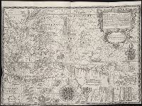
Published / Created:
[ca. 1598]
Call Number:
Taylor 216A
Collection Title:
John Huighen van Linschoten, his Discours of Voyages into ye Easte & West Indies
Image Count:
1
Alternative Title:
Insulae Moluccae ...
Description:
[Scale ca. 1:15,000,000]. and Bound in following page 328.
Subject (Geographic):
Borneo --Maps --Early works to 1800, Indonesia --Maps --Early works to 1800, and New Guinea --Maps --Early works to 1800
Subject (Name):
Wolfe, John, d. 1601, printer
Subject (Topic):
Voyages and travels --Early works to 1800
Collection Created:
[London] : Printed at London by [John Windet for] Iohn Wolfe, printer to ye Honorable Cittie of London, [1598]
Found in:
Beinecke Rare Book and Manuscript Library > Insvlae Molvccae ...
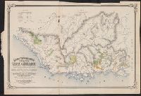
Published / Created:
1872
Call Number:
9115 1872
Image Count:
1
Resource Type:
Maps, Atlases & Globes
Description:
Shows colonies and travel routes between.
Publisher:
F.R. Barros Barreto, S.A. Sissin,
Subject (Geographic):
Santa Catharina (Brazil)--Maps
Found in:
Beinecke Rare Book and Manuscript Library > Mappa Topographico de Parte da Provincia de Santa Catharina ... Organizado pela Commissãodo registro geral e estadistica das terras publicas e possuidas sob a presidencia do Conselheiro Bernardo Augusto Nascientes de Azumbuja ...
Published / Created:
1900?].
Call Number:
9114 1900
Container / Volume:
BRBL_00670
Image Count:
1
Resource Type:
Maps, Atlases & Globes
Publisher:
s.n.,
Subject (Geographic):
Brazil--Maps
Found in:
Beinecke Rare Book and Manuscript Library > Mappa da Capitania de Minas Geraes : com a divisa de suas comarcas.
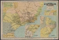
Creator:
Published / Created:
1926
Call Number:
911 1926
Container / Volume:
BRBL_00669
Image Count:
2
Resource Type:
Maps, Atlases & Globes
Alternative Title:
Planta geral da cidade do Rio de Janeiro.
Description:
Includes advertisements and 5 insets. and On verso: Planta geral da cidade do Rio de Janeiro.
Publisher:
Guía Levi,
Subject (Geographic):
Rio de Janeiro (Brazil)--Maps
Subject (Topic):
Railroads--Brazil--Maps and Railroads--Uruguay--Maps
Found in:
Beinecke Rare Book and Manuscript Library > Mappa da viação ferrea dos E.U. do Brasil e da Rep. do Uruguay [cartographic material] / organizado expressamente para o Guía Levi.
Published / Created:
1870
Call Number:
911 1870
Container / Volume:
BRBL_00669
Image Count:
1
Resource Type:
Maps, Atlases & Globes
Description:
Shows boundaries between Brazil and Peru, New Granada (Colombia), Venezuela.
Publisher:
E. Reusburg (lith.),
Subject (Geographic):
Brazil--Maps
Found in:
Beinecke Rare Book and Manuscript Library > Mappa de huma parte da fronteira do norte do imperio do Brazil.
Creator:
Published / Created:
[1913?]
Call Number:
911g 1913
Container / Volume:
BRBL_00672
Image Count:
2
Resource Type:
Maps, Atlases & Globes
Description:
Includes 6 insets and 14 bar graphs.
Publisher:
Chromolithographia Comp. "Fiat Lux",
Subject (Geographic):
Brazil--Economic conditions--Maps
Subject (Name):
Brazil. Ministério da Agricultura, Indústria e Comércio
Found in:
Beinecke Rare Book and Manuscript Library > Mappa económico do Brazil [cartographic material] / Serviço da Informações, Ministério de Agricultura, Indústria e Commércio ; organizado por M. Paulino Cavalcanti.
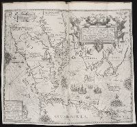
Published / Created:
MDCI [1601]
Call Number:
Taylor 193 3
Collection Title:
Tertia pars Indiae Orientalis ... / de Germanico in Latinum translata, & bono ordine disposita a
Image Count:
1
Description:
In pencil on verso: This map belongs part 2 p 48.
Subject (Geographic):
Borneo --Maps --Early works to 1800, Indonesia --Maps --Early works to 1800, and Java (Indonesia) --Maps --Early works to 1800
Collection Created:
Francofurti : Excudebat Matthaeus Beckerus, anno MDCI [1601]
Found in:
Beinecke Rare Book and Manuscript Library > Nova tabula insularum Iavae, Sumatrae, Borneonis ...
Creator:
Published / Created:
1891
Call Number:
651 1891
Container / Volume:
BRBL_00342
Image Count:
1
Resource Type:
Maps, Atlases & Globes
Alternative Title:
Costa de Cabinda de Chiávola a Muanda
Description:
Relief shown by hachures.
Publisher:
Commissão de Limitação das Fronteiras do Congo,
Subject (Geographic):
Cabinda (Angola : Province)--Maps
Found in:
Beinecke Rare Book and Manuscript Library > Reconhecimento topographico da Costa de Cabinda de Chiávola a Muanda / por E.J. de Costa Oliveira e J. do C. e C. Silva Antnnes.
Published / Created:
1612
Call Number:
Pequot G325
Collection Title:
Descriptio ac delineatio geographica detectionis freti, sive, transitus ad occasum supra terras
Image Count:
1
Abstract:
Map depicts the Coat of Arms of the United Kingdom (era of the Union of the Crowns), reigning between the years 1603-1707.
Alternative Title:
Tabula nautica, qua repraesentantur orae maritimae, meatus, ac freta, noviter a H. Hudsono Anglo ad Caurum supra Novam Franciam
Description:
Bound in after p. [2]., In pencil on recto: 170., Map cut and folded irregularly., Map has multiple small stains on both the recto and verso., and Scale [ca. 1:9,000,000].
Subject (Geographic):
North Atlantic Ocean --Maps --Early works to 1800
Subject (Name):
Hudson, Henry, d. 1611
Collection Created:
Amsterodami Ex officina Hesse lij Gerardi. Anno
Found in:
Beinecke Rare Book and Manuscript Library > Tabula nautica ...
Published / Created:
1612
Call Number:
Taylor 258
Collection Title:
Descriptio ac delineatio geographica detectionis freti, sive, transitus ad occasum supra terras
Image Count:
1
Abstract:
Map depicts the Coat of Arms of the United Kingdom (era of the Union of the Crowns), reigning between the years 1603-1707.
Alternative Title:
Tabula nautica ...
Description:
Bound in after p. [6]., In ink on recto: place names "Okkak", "Nain"[?] and one longer handwritten note on the bottom margin., Map cut and folded irregularly., Map has been repaired with multiple pieces of tape on verso., Map has multiple small stains on both the recto and verso., Printed on recto in lower right corner: A1., and Scale [ca. 1:9,000,000].
Subject (Geographic):
North Atlantic Ocean --Maps --Early works to 1800
Subject (Name):
Hudson, Henry, d. 1611
Collection Created:
Amsterodami Ex officina Hesse lij Gerardi. Anno 1613
Found in:
Beinecke Rare Book and Manuscript Library > Tabula nautica, qua repraesentantur orae maritimae, meatus, ac freta, noviter a H. Hudsono Anglo ad Caurum supra Novam Franciam
Branch:v1.62.0 ,Deployed:2024-06-26T09:57:02-04:00