"Longitude taken from the Iron Island.", From "An Universal History, from the Earliest Account of Time" (1747)., In upper right corner, "Vol. 1, facing page 1.", Relief shown pictorially., and Watermark.
Publisher:
[Thomas Osborne],
Subject (Geographic):
Middle East--Historical geography--Maps--Early works to 1800.
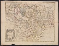
Map of Turkey, Arabia & Persia and Map of Turkey, Arabia and Persia
Description:
Appears in Senex's A new general atlas ... London: Printed for Daniel Browne ... [etc.], 1721., Relief shown pictorially., and Sheet measures 53 x 69 cm. Cross Collection no. 104.
Publisher:
Sold by John Senex at the Globe against St. Dunstans Church Fleetstreet,
Subject (Geographic):
Africa--Maps--Early works to 1800, Arabian Peninsula--Maps--Early works to 1800, Iran--Maps--Early works to 1800, and Middle East--Maps--Early works to 1800
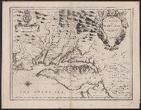
Appears in Speed's The theatre of the Empire of Great Britaine., English on recto, verso., Oriented west., Relief shown pictorially., Sheet measures 43.5 x 56 cm. Cross Collection no. 215., and Verso: Page nos. 43-44; titles "The description of Mary-land", "The description of Virginia"; signature Y.
Publisher:
Sold by Thomas Basset in Fleetstreet and Richard Chiswell in St. Pauls Church yard,
Subject (Geographic):
Maryland--History--Colonial period, ca. 1600-1775--Maps--Early works to 1800, Maryland--Maps--Early works to 1800, Virginia--History--Colonial period, ca. 1600-1775--Maps--Early works to 1800, and Virginia--Maps--Early works t
Subject (Name):
Bassett, Thomas, bookseller, Chiswell, Richard, Lamb, Francis, engraver, and Speed, John, 1552?-1629. Theatre of the Empire of Great Britaine
Appears in Speed's The theatre of the Empire of Great Britaine., English on recto, verso., Hand col. Sheet measures 41.7 x 54.4 cm., Oriented west., Relief shown pictorially., and Verso: Page nos. 43-44; titles "The description of Mary-land", "The descr
Publisher:
Sold by Thomas Basset in Fleetstreet and Richard Chiswell in St. Pauls Church yard,
Subject (Geographic):
Maryland--History--Colonial period, ca. 1600-1775--Maps--Early works to 1800, Maryland--Maps--Early works to 1800, Virginia--History--Colonial period, ca. 1600-1775--Maps--Early works t, and Virginia--Maps--Early works to 1800
Subject (Name):
Bassett, Thomas, bookseller, Chiswell, Richard, Lamb, Francis, engraver, and Speed, John, 1552?-1629. Theatre of the Empire of Great Britaine
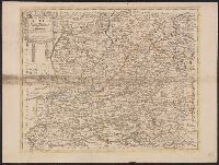
Dated from other maps in the atlas., Decorative title cartouche., From Senex's A new general atlas ... London: Printed for Daniel Browne ... [etc.], 1721., Hand col. Mounted on linen. Sheet measures 50 x 67 cm. Cross Collection no. 93., London meridian., Relief shown pictorially., and Shows boundaries, rivers, roads, and settlements.
Publisher:
Sold by John Senex ...,
Subject (Geographic):
Castile (Spain)--Early works to 1800--Maps
Subject (Name):
Méndez Silva, Rodrigo, 1607-1675, Senex, John, d. 1740, and Senex, John, d. 1740. New general atlas
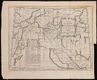
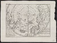
"Vol. I. p. 805" in upper left corner., Appears in: Atlas minor, or, A new and curious set of sixty-two maps. [London] : Printed for Tho: Bowles next ye Chapter House in St. Pauls Church Yard, & John Bowles at the Black Horse in Cornhill ..., [1736?], Cross collection no. 53., From: Thomas Salmon's Modern history. London : Printed for Messrs. Bettesworth and Hitch, J. Clarke, S. Birt, Tho. Wotton, and J. Shuckburgh, and T. Osborne, 1739., Includes text., and Relief shown pictorially.
Publisher:
Printed for Tho. Bowles next the Chapter house in St. Pauls church yard & Iohn Bowles at the Black Horse in Cornhill,
Subject (Geographic):
Arctic Regions--Maps--Early works to 1800 and North Pole--Maps--Early works to 1800
Subject (Name):
Bowles, John, 1701-1779, bookseller, Bowles, Thomas, -1767, bookseller, and Salmon, Thomas, 1679-1767. Modern history
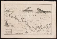
"No. 58" at bottom left; "Plate XLII. Vol. 2 page 159" at bottom right., Coordinates not present on map and are approximated., Relief shown pictorially and by soundings., Shows topography, waterways, routes, settlements., and Watermark.
Publisher:
[publisher not identified],
Subject (Geographic):
Gambia River--Maps--Early works to 1800. and Gambia--Maps--Early works to 1800.
Insets: View of the City of Mexico with index, La Vera Cruz Harbor, Havana Harbor, The bay of Porto Bella, St. Agustin Harbor, Cartagena. and This edition apparently later than *85 1708A, as it has imprint Printed for Thomas Bowels ... and Ion Bowels ... [and] Sold by H. Moll and by I. Ring ...