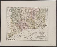
"Zu Ebelings Erdbeschreib, Also shows county boundaries., Bar scales given in "Geographische Meilen 15 auf einen Grad" and "Englische meilen 69 4/25 auf einen Grad.", In upper right margin: No. VI., Place names in German and English., and Relief shown by hachures.
Publisher:
Bey Carl Ernst Bohn,
Subject (Geographic):
Connecticut--Administrative and political divisions--Maps--Early works to 1800 and Connecticut--Maps--Early works to 1800
Subject (Name):
Bohn, Carl Ernst, Ebeling, Christophe Daniel, 1741-1817. Erdbeschreibung und Geschichte von Amerika, and Schmidt, Paulus, engraver
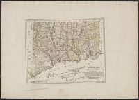
"Zu Ebelings Erdbeschreibung von Amerika.", Also shows county boundaries., Bar scales given in "Geographische Meilen 15 auf einen Grad" and "Englische meilen 69 4/25 auf einen Grad.", In upper right margin: No. VI., Place names in German and English., and Prime me
Publisher:
Bey Carl Ernst Bohn,
Subject (Geographic):
Connecticut--Administrative and political divisions--Maps--Early works to 1800 and Connecticut--Maps--Early works to 1800
Subject (Name):
Bohn, Carl Ernst, Ebeling, Christophe Daniel, 1741-1817. Erdbeschreibung und Geschichte von Amerika, and Schmidt, Paulus, engraver
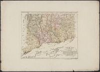
"Zu Ebelings Erdbeschreibung von Amerika.", Also shows county boundaries., Bar scales given in "Geographische Meilen 15 auf einen Grad" and "Englische meilen 69 4/25 auf einen Grad.", In upper right margin: No. VI., Place names in German and English., and Prime me
Publisher:
Bey Carl Ernst Bohn,
Subject (Geographic):
Connecticut--Administrative and political divisions--Maps--Early works to 1800 and Connecticut--Maps--Early works to 1800
Subject (Name):
Bohn, Carl Ernst, Ebeling, Christophe Daniel, 1741-1817. Erdbeschreibung und Geschichte von Amerika, and Schmidt, Paulus, engraver
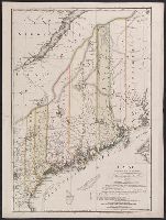
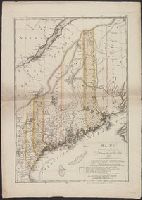
"Zu Ebelings Erdbeschreibung von America.", Also shows county boundaries., Bar scales given in "Geographische Meilen 15 auf einen Grad" and "Englische meilen 69 4/25 auf einen Grad.", Includes index to land grants., Place names in German and Englis, and Watermark.
Publisher:
Bey Carl Ernst Bohn,
Subject (Geographic):
Maine--Administrative and political divisions--Maps--Early works to 1800 and Maine--Maps--Early works to 1800
Subject (Name):
Bohn, Carl Ernst, Ebeling, Christoph Daniel,--1741-1817--Presentation inscription to N. Webster, Ebeling, Christophe Daniel, 1741-1817. Erdbeschreibung und Geschichte von Amerika, and Sander, Wilhelm, 1766-1836, engraver
"Zu Ebelings Erdbeschreibung von America.", Also shows county boundaries., In upper right margin: No. IV., Includes index to land grants., Place names in German and English., Prime meridians: Greenwich a, Relief shown by hachures., and Sheet measures 75.5 x 53.8 cm.
Publisher:
Bey Carl Ernst Bohn,
Subject (Geographic):
Maine--Administrative and political divisions--Maps--Early works to 1800 and Maine--Maps--Early works to 1800
Subject (Name):
Bohn, Carl Ernst, Ebeling, Christophe Daniel, 1741-1817. Erdbeschreibung und Geschichte von Amerika, and Sander, Wilhelm, 1766-1836, engraver
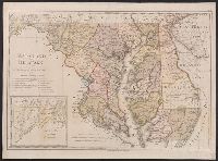
"W. Sander sculp.", "Zu Ebelings Erdbeschreibung von Amerika.", In upper right margin: No. X., Includes inset of western section of what is now Garrett and Allegany Counties., No watermark. Sheet measures 50.8 x 68.8 cm. Franklin Collection no. 131 1797-3., Place names in English and German., Prime meridians: Greenwich and Washington., Relief shown by hachures., and Watermark.
Publisher:
Bey Carl Ernst Bohn,
Subject (Geographic):
Delaware--Administrative and political divisions--Maps--Early works to 1800, Delaware--Maps--Early works to 1800, Maryland--Administrative and political divisions--Maps--Early works to 1800, and Maryland--Maps--Early works to
Subject (Name):
Bohn, Carl Ernst, Ebeling, Christophe Daniel, 1741-1817. Erdbeschreibung und Geschichte von Amerika, and Sander, Wilhelm, 1766-1836, engraver
"Zu Ebelings Erdbeschreibung von Amerika.", Also shows county boundaries., Atlas plate: No. III., Place names in German and English., Prime meridians: Greenwich and Washington., Relief shown by hachures. Depths shown by soundings., and Sheet measures 51 x 70 cm. Franklin Collection no. 131 1796 3.
Publisher:
Bey Carl Ernst Bohn,
Subject (Geographic):
Massachusetts--Administrative and political divisions--Maps--Early works to 1800 and Massachusetts--Maps--Early works to 1800
Subject (Name):
Bohn, Carl Ernst, publisher, Ebeling, Christophe Daniel, 1741-1817. Erdbeschreibung und Geschichte von Amerika, and Schmidt, Paulus Christoph, engraver
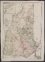
"Zu Ebelings Erdbeschreibung von Amerika.", Also shows county boundaries., In upper left margin: No. II., Inset: Nördlicher Theil der Grafschaft Grafton., Not colored. Sheet measures 71.3 x 51.3 cm. Franklin Collection no. 131 1796 4., Place names in German and English., Prime meridians: Greenwich and Washington., Relief shown by hachures., and Watermark.
Publisher:
Bey Carl Ernst Bohn,
Subject (Geographic):
New Hampshire--Administrative and political divisions--Maps--Early works to 1800 and New Hampshire--Maps--Early works to 1800
Subject (Name):
Bohn, Carl Ernst, Ebeling, Christophe Daniel, 1741-1817. Erdbeschreibung und Geschichte von Amerika, and Schmidt, Paulus, engraver
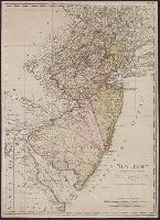
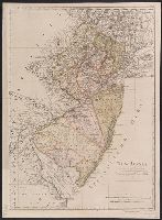
"Zu Ebelings Erdbeschreibung von Amerika.", Bar scales given in "Geographische Meilen 15. auf einen Grad" and "Englische meilen 69 4/25 auf einen Grad.", In upper right margin: No. VIII., Mounted on linen. Sheet measures 67.0 x 48.6 cm. Cross Collection no. 205., Place names in English and German., Prime meridians: Greenwich and Washington., Relief shown by hachures., and Watermark.
Publisher:
Bey Carl Ernst Bohn,
Subject (Geographic):
New Jersey--Administrative and political divisions--Maps--Early works to 1800 and New Jersey--Maps--Early works to 1800
Subject (Name):
Bohn, Carl Ernst and Ebeling, Christophe Daniel, 1741-1817. Erdbeschreibung und Geschichte von Amerika
"Zu Ebelings Erdbeschreibung von Amerika.", Bar scales given in "Geographische Meilen 15. auf einen Grad" and "Englische meilen 69 4/25 auf einen Grad.", In upper right margin: No. VIII., No watermark. Sheet measures 69.8 x 51.0 cm. Franklin Collection no. 131 1797 2., Place names in English and German., Prime meridians: Greenwich and Washington., Relief shown by hachures., and Watermark.
Publisher:
Bey Carl Ernst Bohn,
Subject (Geographic):
New Jersey--Administrative and political divisions--Maps--Early works to 1800 and New Jersey--Maps--Early works to 1800
Subject (Name):
Bohn, Carl Ernst and Ebeling, Christophe Daniel, 1741-1817. Erdbeschreibung und Geschichte von Amerika