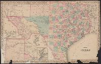
"Entered according to act of Congress in the year 1873 by G.W. & C.B. Colton & Co. in the office of the Librarian of Congress at Washington.", Insets: Plan of Matagorda Bay. Scale [ca. 1:1,060,000] -- Plan of the, and Prime meridians: Greenwich and Washington.
Publisher:
G.W. & C.B. Colton & Co.,
Subject (Geographic):
Texas Panhandle (Tex.)--Maps, Texas--Administrative and political divisions--Maps, and Texas--Maps
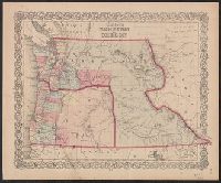
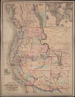
"Entered according to act of Congress in the year 1853 by J.H. Colton & Co. in the clerk's office of the district court of the United States for the southern district of New York.", Covers Washington, Oregon, and Idaho., In lower right corner: No. 53., and Prime meridians: Greenwich and Washington, D.C.
Colton, G. Woolworth (George Woolworth), 1827-1901
Published / Created:
1862
Call Number:
754gme 1860A
Container / Volume:
BRBL_00420
Image Count:
1
Resource Type:
Maps, Atlases & Globes
Alternative Title:
Colton's county and township railroad map of Wisconsin, Illinois, Missouri, & Iowa, County and township rail road map of Wisconsin, Illinois, Missouri, & Iowa, and Wisconsin, Illinois, Missouri, & Iowa
Description:
"Entered according to Act of Congress by Thayer & Colton in the Clerk's office of the District Court of the United States for the Southern District of New York in t and Does not include northern half of Wisconsin; Appleton is the northernmost town on the map.
Publisher:
Drawn, engraved & published by G. Woolworth Colton; and Rufus Blanchard,
Subject (Geographic):
Illinois--Maps, Iowa--Maps, Missouri--Maps, and Wisconsin--Maps
Subject (Name):
Blanchard, Rufus, 1821-1904
Subject (Topic):
Railroads--Illinois--Maps, Railroads--Iowa--Maps, Railroads--Missouri--Maps, and Railroads--Wisconsin--Maps
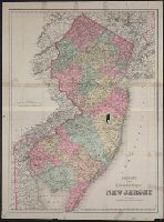
"Entered according to Act of Congress in the year 1879 by G.W. & C.B. Colton & Co. in the clerks office of the District of Court of the United States for the Eastern District of New York." and Relief shown by hachures.
Publisher:
G.W. & C.B. Colton & Co.,
Subject (Geographic):
New Jersey--Maps.
Subject (Name):
Colton, C. B, Colton, G. Woolworth (George Woolworth), 1827-1901, and G.W. & C.B. Colton & Co
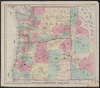
Colton's map of Oregon and Washington Territory and Map of Oregon & Washington Territory
Description:
"Entered according to act of Congress in the year 1879 by G.W. & C.B. Colton & Co. ....", Includes ill. of steamships along Oregon Steamship Co. and Alaska & Sitka Steamer routes., Prime meridians: Greenwich and Washington, D.C., Relief shown by hachures., and Shows Oregon, Washington, and western Idaho.
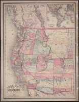
Insets: Map of the Atlantic Ocean, showing parts of the eastern & western continents -- Vicinity of San Francisco. and Relief shown by hachures and spot heights.
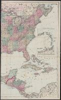
"Entered according to Act of Congress in the year 1867 by G.W. & C.B. Colton & Co. ...", Hand col., and Shows roads, railroads, and projected railroads.