Skip to search
Skip to main content
Skip to first result
Search
You Searched For
Extent of Digitization
Partially digitized
Format
cartographic
Subject (Topic)
Atlases--Early works to 1800
New Search
Search Results
Creator:
Published / Created:
[1732]
Call Number:
E1015 M66 1732
Collection Title:
Atlas minor: or a set of sixty-two new and correct maps, of all parts of the world. All composed
Image Count:
1
Description:
Autograph of Gravely. Autograph of Baldock. Autograph of Aston. Autograph of W. Alington. and Teaching resource: Professor John Mack Faragher, History 141: The American West.
Subject (Geographic):
America--Maps--Early works to 1800 and Fundy, Bay of--Maps
Subject (Topic):
Atlases--Early works to 1800
Collection Created:
London :
Found in:
Beinecke Rare Book and Manuscript Library > A description of the Bay of Fundy showing ye coast, islands, harbours, creeks, coves, rocks, sholes, soundings & anchorings &c... Observed by Nat. Blackmore in ye yeare 1711 and 1712 ...
Creator:
Published / Created:
[1732]
Call Number:
E1015 M66 1732
Collection Title:
Atlas minor: or a set of sixty-two new and correct maps, of all parts of the world. All composed
Image Count:
1
Resource Type:
Maps, Atlases & Globes
Description:
Autograph of Gravely. Autograph of Baldock. Autograph of Aston. Autograph of W. Alington. and Teaching resource: Professor John Mack Faragher, History 141: The American West.
Subject (Geographic):
America--Maps, Europe, Northern--Maps--Early works to 1800, Great Britain--Maps--Early works to 1800, and Ireland--Maps--Early works to 1800
Subject (Topic):
Atlases--Early works to 1800
Collection Created:
London :
Found in:
Beinecke Rare Book and Manuscript Library > A general map of Great Britain and Ireland with part of Germany, Holland, Flanders, France &c. agreeable to modern history
Creator:
Published / Created:
[1732]
Call Number:
E1015 M66 1732
Collection Title:
Atlas minor: or a set of sixty-two new and correct maps, of all parts of the world. All composed
Image Count:
1
Description:
Autograph of Gravely. Autograph of Baldock. Autograph of Aston. Autograph of W. Alington.
Subject (Geographic):
America--Maps--Early works to 1800
Subject (Topic):
Atlases--Early works to 1800
Collection Created:
London :
Found in:
Beinecke Rare Book and Manuscript Library > A map of the West-Indies & c. Mexico or New Spain. Also ye trade winds, and ye several tracts made by ye galeons and flota from place to place. By H. Moll geographer.
Creator:
Published / Created:
[1732]
Call Number:
E1015 M66 1732
Collection Title:
Atlas minor: or a set of sixty-two new and correct maps, of all parts of the world. All composed
Image Count:
1
Description:
Autograph of Gravely. Autograph of Baldock. Autograph of Aston. Autograph of W. Alington.
Subject (Geographic):
America--Maps--Early works to 1800
Subject (Topic):
Atlases--Early works to 1800
Collection Created:
London :
Found in:
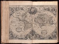
Beinecke Rare Book and Manuscript Library > A new map of the whole world with the trade winds according to ye latest and most exact observations by H. Moll geographer.
Creator:
Published / Created:
[1732]
Call Number:
E1015 M66 1732
Collection Title:
Atlas minor: or a set of sixty-two new and correct maps, of all parts of the world. All composed
Image Count:
1
Description:
Autograph of Gravely. Autograph of Baldock. Autograph of Aston. Autograph of W. Alington.
Subject (Geographic):
America--Maps--Early works to 1800
Subject (Topic):
Atlases--Early works to 1800
Collection Created:
London :
Found in:
Beinecke Rare Book and Manuscript Library > A new map of ye north parts of America claimed by France under ye names of Louisiana. Mississipi, Canada & New France, with the adjoyning territories of England & Spain. By H. Moll geographer.
Creator:
Published / Created:
[1703?]
Call Number:
1975 Folio 55
Image Count:
6
Description:
Colophon: Amstelodami, apud Theodorus Danckerts ..., Engraved t.-p., col., with imprint on mounted slip; imprint on verso of t.-p.: Amstelodami, apud Fredericum de Wit ..., and Maps signed by Justus, Cornelis, Theodore or Johann Danckerts, Frederick de Wit and others.
Publisher:
Bij Iustus Danckers in de Calverstraet in de Dancbaerheijt
Subject (Topic):
Atlases--Early works to 1800
Found in:
Beinecke Rare Book and Manuscript Library > Atlas
Creator:
Published / Created:
[178-?]
Call Number:
1973 Folio 113
Image Count:
2
Resource Type:
Maps, Atlases & Globes
Alternative Title:
New and curious set of sixty two maps.
Description:
"The United States of North America, with the British & Spanish territories": no. 46. and Title-page engraved.
Publisher:
Printed for R. Wilkinson, at No. 58 in Cornhill
Subject (Topic):
Atlases--Early works to 1800 and Geography--Early works to 1800
Found in:
Beinecke Rare Book and Manuscript Library > Atlas minor: or A new and curious set of sixty two maps, in which are shewn all the empires, kingdoms, countries, states in all the known parts of the earth ... by Herman Moll ...
Creator:
Published / Created:
[1732]
Call Number:
E1015 M66 1732
Image Count:
1
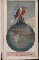
Description:
Autograph of Gravely. Autograph of Baldock. Autograph of Aston. Autograph of W. Alington. and Teaching resource: Professor John Mack Faragher, History 141: The American West.
Publisher:
Printed for Thomas Bowles, next to the Chapter-house in St. Paul’s Church-yard, and John Bowles, at the Black Horse in Cornhill ...,
Subject (Geographic):
America--Maps--Early works to 1800
Subject (Topic):
Atlases--Early works to 1800
Found in:
Beinecke Rare Book and Manuscript Library > Atlas minor: or a set of sixty-two new and correct maps, of all parts of the world. All composed and done by Herman Moll, geographer ...
Creator:
Published / Created:
1633
Call Number:
1973 Folio 120
Image Count:
1
Description:
At head of title: Gerardi Mercatoris et I. Hondii., Engraved t.-p., and The paging is irregular, because many maps were inserted with the same page numbering as the preceding map.
Publisher:
Chez Henry Hondius,
Subject (Topic):
Atlases--Early works to 1800
Found in:
Beinecke Rare Book and Manuscript Library > Atlas; ou, Repreísentation du monde vniversel, et des parties d'icilui, faicte en tables et descriptions tres amples et exactes: Diviseí en deux tomes
Creator:
Published / Created:
[1732]
Call Number:
E1015 M66 1732
Collection Title:
Atlas minor: or a set of sixty-two new and correct maps, of all parts of the world. All composed
Image Count:
1
Description:
Autograph of Gravely. Autograph of Baldock. Autograph of Aston. Autograph of W. Alington.
Subject (Geographic):
America--Maps--Early works to 1800
Subject (Topic):
Atlases--Early works to 1800
Collection Created:
London :
Found in:
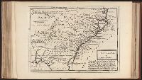
Beinecke Rare Book and Manuscript Library > Carolina by H. Moll geographer.
Branch:v1.61.6 ,Deployed:2024-06-12T09:55:36-04:00