"Emanl. Bowen sculp." and Insets: Plan of the Harbours of Ferrol and the Groyne -- Plan of St Sebastian -- Plan of Barcelona -- Plan of the Bay and City of Cadiz -- Plan of
Publisher:
T. Jefferys,
Subject (Name):
Bowen, Emanuel, d. 1767
Subject (Topic):
Coasts--Europe, Western--Maps--Early works to 1800 and Nautical charts--Europe, Western--Early works to 1800
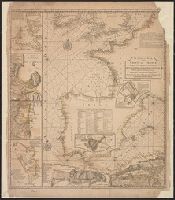
Includes text, decorative cartouche with port. of Peter the Great, and insets of northern Russia, the Don River Delta, and the Volga River., Prime meridians: Ferro and London., and Relief shown pictorially. Depths shown by soundings.
Publisher:
Printed for H. Moll between Temple Bar & St. Clem. Church in ye Strand, D. Midwinter at ye 3 Crowns in St. Pauls Church yard, P. Overton over against S. Dunstans Church in Fleetstreet & T. Bowles next to the chapter house in St. Pauls Church yard,
Subject (Geographic):
Europe, Eastern--Maps--Early works to 1800 and Russia--Maps--Early works to 1800
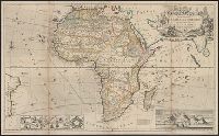
"According to the newest and most exact observations.", Includes views of "Cape Coast Castle on ye gold coast of Guinea," "James Fort on the island of St. Helena," and "A prospect of the Cape of Good Hope," and a plan of, and Prime meridians: London and Ferro.
Publisher:
Printed for H. Moll over against Devereux Court without Temple Bar, D. Midwinter at the 3 Crowns in St. Pauls church yard and Tho. Bowles print and mapseller next to the chapter house in St. Pauls church yard by Philip Overton, map and printseller near St
Subject (Geographic):
Africa--Maps--Early works to 1800
Subject (Name):
Bowles, Thomas, -1767, Midwinter, Daniel, active 1698-1725, and Overton, Philip, -1751
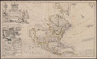
North America, according to ye newest and most exact observations
Description:
Appears in the author's The world described, or a new and correct sett of maps., Has watermark., Includes text, 10 insets of North American ports, decorative cartouche with coat of arms and figures, and "view of a stage & also, and Shows California as an island.
Publisher:
Printed for H. Moll, D. Midwinter at ye 3 Crowns in St. Pauls Church yard, T. Bowles ... next to the chapter house in St. Pauls Church yard, and over against Devereux Court, without Temple Bar, and by P. Overton ... near St. Dunstans Church Fleetstreet,
Subject (Geographic):
North America--Maps--Early works to 1800
Subject (Name):
Lens, Bernard, 1659-1725, Moll, Herman, d. 1732. World described, and Vertue, George, 1684-1756
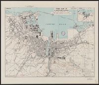
Great Britain. War Office. General Staff. Geographical Section
Published / Created:
1943
Call Number:
38 C42 1943
Container / Volume:
BRBL_00156
Image Count:
1
Resource Type:
Maps, Atlases & Globes
Alternative Title:
Geographical Section, General Staff ; no. 4234 and GSGS (Series) ; 4234.
Description:
"3rd edition 1943.", "Air photographs have been used in the production of this plan.", "Contours at 10 metres interval.", "N4937.4-W134.5/2.5x5.", "Published by War Office, 1941.", Important streets and buildings are named., and Includes inset map: Environs of Cher
Publisher:
[Printed by] Army Map Service, U.S. Army, and Published by War Office ;
"Published under the superintendence of the Society for the Diffusion of Useful Knowledge.", Dissected and mounted on cloth. Folds to 9 x 10 cm. Ms. note on verso: Venice. dgvmp2008., and Insets: [1.] View of the Mint, St. Mark's Church, the Palace
Publisher:
Society for the Diffusion of Useful Knowledge,
Subject (Geographic):
Venice (Italy)--Maps
Subject (Name):
Davies, Benjamin Rees and Society for the Diffusion of Useful Knowledge (Great Britain)