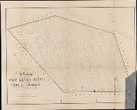
United States. War Department. Corps of Engineers, cartographer, publisher
Published / Created:
[1875?]
Call Number:
831 1875
Image Count:
1
Resource Type:
cartographic image
Description:
BEIN 831 1875: Imperfect: eastern sheet wanting; western sheet chipped. Inscription below edition statement: Lieut. [?] F. Eng., 5th Infty. Inscription on verso: Capt. Ludlow's map, 1875, sheet no. 1., Relief shown by hachures., Scale "1 inch - 12 miles.", Shows battle sites and military expeditions, with dates., and In upper left margin: Brig. Genl. A.A. Humphreys, Chief of Engineers.
Relief shown pictorially., North oriented down., Bar scale given in unidenified units., Coordinates not present on map and are approximated., Includes index of colleges, buildings, and streets., and Insets: view of Oxforde and a map of Oxfordshire with bar scale in miles.
BEIN BrSides Folio 2014 10: Imperfect: torn and mutilated, with lower right corner missing., "Area 18 acres.", and Removed from: History of the city burial ground, in New Haven, together with the names of the owners of the lots therein (1863).
Publisher:
publisher not identified and Lith. by Punderson & Crisand
BEIN Folio G1244 N48 S26 1973: Imperfect: sheets 351-352 wanting. Disbound., Title from accompanying letter., Unpublished. Available upon request at the Sanborn Map Company, Inc., Also referred to by Publisher as Atlas of New Haven, Connecticut., and Contains information on population, prevailing winds, water facilities and fire department.
BEIN BrSides Zc35 908un: Holes punched in margins.
Publisher:
Dept. of the Interior, General Land Office, Andrew B. Graham Co.)
Subject (Geographic):
Cheyenne River Indian Reservation (S.D.), Standing Rock Indian Reservation (N.D. and S.D.), South Dakota, Cheyenne River Indian Reservation., United States, and Standing Rock Indian Reservation.
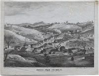
Goddard, George H. (George Henry), 1817-1906, artist
Published / Created:
May 1853.
Call Number:
WA Prints 391
Image Count:
1
Resource Type:
cartographic image
Description:
BEIN copy 1: Foxed with fading. On sheet 21 x 26 cm., BEIN copy 2: Foxed. On sheet 21 x 26 cm., Coordinates not present on map and are approximated., and Relief shown pictorially.
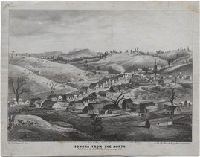
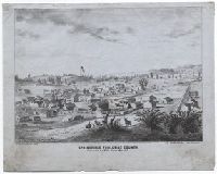
Goddard, George H. (George Henry), 1817-1906, artist
Published / Created:
May 1853.
Call Number:
WA Prints 432
Image Count:
1
Resource Type:
cartographic image
Description:
BEIN WA Prints 432 copy 1: On sheet: 23 x 28 cm., BEIN WA Prints 432 copy 2: Imperfect: Foxed, with some fading. On sheet: 21 x 27 cm., Relief shown pictorially., and Coordinates not present on map and are approximated.