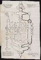
The American military pocket atlas : being an approved collection of correct maps, both general and
Image Count:
1
Description:
Augst. 5th. 1776., Inset: A particular plan of Lake George. surveyed in 1756. By Capt. Jackson., and Teaching resource: Professor John Mack Faragher, History 141: The American West.
Publisher:
Printed for Robt. Sayer & Jno. Bennett, Map & Sea Chartsellers No. 53 Fleet Street, as the Act directs
Subject (Geographic):
North America --Maps --Early works to 1800 and United States --History --Revolution, 1775-1783 --Maps
Collection Created:
London : Printed for R. Sayer and J. Bennet, [1776]
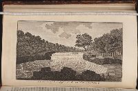
An historical, geographical, commercial, and philosophical view of the American United States, and
Image Count:
1
Description:
Facing p. 396.
Publisher:
Printed for the editor; J. Ridgway [etc.]
Subject (Geographic):
America --Description and travel, America --History --To 1810, Ohiopyle (Pa.), Pennsylvania --Pictorial works, and United States --Description and travel
Collection Created:
London, Printed for the editor; J. Ridgway [etc.] 1795
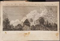
Travels through the interior parts of America. In a series of letters. By an officer ...
Image Count:
1
Description:
1 Jan. 1789., Between p. 350 & p. 351., and Teaching resource: Professor John Mack Faragher, History 141: The American West.
Subject (Geographic):
Canada --Description and travel, United States --Description and travel --Early works to 1800, and United States --History --Revolution, 1775-1783 --Personal narratives, British
Title from item., Published in: Gleason's Pictorial Drawing-Room Companion, Boston: Frederick Gleason, 19 March 1853., This electronic record is derived from historic data and may not reflect our current information. Review and updating of records is ongoing., and Temporary local Medical Library subject terms: Families & family life.
Publisher:
Frederick Gleason
Subject (Name):
Bunker, Chang, 1811-1874. and Bunker, Eng, 1811-1874.
Subject (Topic):
Conjoined twins, Abnormalities, Human, Human curiosities, Families, Spouses, and Children
Also appeared in Faden's [General atlas. London : William Faden, 1811?]., Includes relief profiles and inset map of "Positions ascertained by courses and distances given; on a scale reduced to the third.", No. 42 of 43 maps bound together in composite atlas., Relief shown pictorially; depths by soundings., and Scale [ca. 1:2,700,000].
Publisher:
Wm. Faden
Subject (Geographic):
Antilles, Lesser --Maps --Early works to 1800
Subject (Topic):
Nautical charts --Antilles, Lesser --Early works to 1800