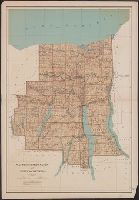
Relief shown by spot heights. and Shows roads, railroads, settlements, original patents, towns, etc.
Publisher:
Julius Bien & Co.,
Subject (Geographic):
Ontario County (N.Y.)--Maps, Seneca County (N.Y.)--Maps, Wayne County (N.Y.)--Maps, and Yates County (N.Y.)--Maps
Subject (Name):
Bien, Joseph R. Atlas of the state of New York, New York : Julius Bien & Co., 1895. pl. 29 and Julius Bien & Co
Subject (Topic):
Land grants--New York (State)--Ontario County--Maps, Land grants--New York (State)--Seneca County--Maps, Land grants--New York (State)--Wayne County--Maps, and Land grants--New York (State)--Yates County--Maps
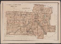
From: Atlas of the state of New York. New York : Julius Bien & Co., 1895., Relief shown by spot heights., and Show roads, railroads, settlements, original patents, towns, etc.
Publisher:
Julius Bien & Co.,
Subject (Geographic):
Livingston County (N.Y.)--Maps and Wyoming County (N.Y.)--Maps
Subject (Name):
Bien, Joseph R. Atlas of the state of New York and Julius Bien & Co
Subject (Topic):
Land grants--New York (State)--Livingston County--Maps and Land grants--New York (State)--Wyoming County--Maps
"Julius Bien & Co. Lith. N.Y.", "Surveyed in 1899.", Plate CXXXVIII from the "Twenty-first annual report" of the U.S. Geological Survey, Part 5, Forest reserves (1900)., Relief shown by contours and spot heights., and Shows six classes of land cover.
Publisher:
The Survey,
Subject (Geographic):
Bighorn National Forest (Wyo.)--Maps and Sheridan County (Wyo.)--Maps
Subject (Name):
Geological Survey (U.S.). Annual report, Julius Bien & Co, and Tweedy, Frank, 1854-1937
Subject (Topic):
Forests and forestry--Wyoming--Sheridan County--Maps and Land capability for agriculture--Wyoming--Sheridan County--Maps
"Engraved Apr. 1901 by Julius Bien & Co.", "Surveyed, Plate CXLI from the "Twenty-first annual report" of the U.S. Geological Survey, Part 5, Forest reserves (1900)., Relief shown by contours and spot heights., and Shows four classes of land cover.
Publisher:
The Survey,
Subject (Geographic):
Black Hills National Forest (S.D. and Wyo.)--Maps and Weston County (Wyo.)--Maps
Subject (Name):
Geological Survey (U.S.). Annual report and Julius Bien & Co
Subject (Topic):
Forests and forestry--Wyoming--Weston County--Maps and Land capability for agriculture--Wyoming--Weston County--Maps
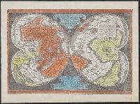
"Ne que ad nos Fram orbis ... Cappadocie 7.", "Quam hic vides orbis imagine lector cadide ... Vale 1538", Cordiform map of the world, 1538, Joanni Drosio suo Gerardus Rupelmudan deducabat., Map of the world, 1538, Orbis imago., and World map on double cordiform pro
Description:
Also known as World map on double cordiform projection and Orbis imago., Cross collection no. 4., Facsimile of Gerhard Mercator's first world map, published in Louvain, 1538., Relief shown pictorially., and Title from another facsimile published by the New York Public Library.
Publisher:
Julius Bien & Co., photo-lith,
Subject (Name):
Brevoort, James Carson, 1818-1887 and Julius Bien & Co
Subject (Topic):
Early maps--Facsimiles and World maps--Early works to 1800--Facsimiles