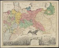
Preliminary record. and The map (bounded by Frisia, Jutland, Prussia, Poland and extending South to include Silesia and parts of Bavaria and Lotharingia) occupies the upper half of the sheet; the lower half shows an engraved battle scence ...
Russian S.F.S.R. Narodnyĭ komissariat vnutrennikh del Russian S.F.S.R. Народный комиссариат внутренних дел
Published / Created:
1930]
Call Number:
352 1930B
Container / Volume:
BRBL_00106
Image Count:
2
Resource Type:
Maps, Atlases & Globes
Alternative Title:
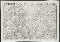
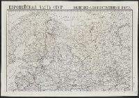
Административная карта европеиской частьи С.С.С.Р. / составлена и издана Kартоиздательством Н.К.В.Д. Р.С.Ф.С.Р.
Description:
"Glavlit No. A-52827.", "Granit︠s︡y na 1-e i︠a︡nvari︠a︡ 1930 g.", "Vypusk 2/24.", "Выпуск 2/24.", "Главлит No. А-52827.", "Границы на 1-е января 1930 г.", and 352 1930B: Imperfect: Mutilated with loss of text.
Publisher:
Kartoizdatelʹstvo N.K.V.D. R.S.F.S.R., and Kартоиздательство Н.К.В.Д. Р.С.Ф.С.Р.,
Subject (Geographic):
Soviet Union, Western--Administrative and political divisions--Maps
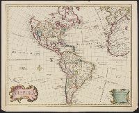
Includes text., Prime meridian: Ferro., Relief shown pictorially., Shows northwest coast in the form used in Guillaume De L'Isle's 1722 map of America. Cf. Wagner, H.R. Cartog. of the NW coast, p. 142., and Tooley refers to this map in Mapping of America, p. 13,
Publisher:
s.n.,
Subject (Geographic):
America--Maps--Early works to 1800
Subject (Name):
L'Isle, Guillaume de, 1675-1726 and L'Isle, Joseph Nicolas de, 1688-1768
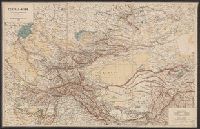
Atlas severozapadnykh beregov Ameriki ot Beringova proliva do mysa Korriėntes i ostrovov Aleutskikh s prisovokupleniem nekotorykh mest severovostochnago berega Azii, Gidrograficheskīi︠a︡ zami︠e︡chanīi︠a︡ kʺ atlasu si︠e︡verozapadnykhʺ beregovʺ Ameriki, ostrovovʺ Aleutskikhʺ i ni︠e︡kotorykhʺ drugikhʺ mi︠e︡stʺ Si︠e︡vernago Tikhago okeana, Gidrograficheskii︠a︡ zamechanii︠a︡ k atlasu severozapadnykh beregov Ameriki, ostrovov Aleutskikh i nekotorykh drugikh mest Severnogo Tikhogo okeana, Атлас северозападных берегов Америки от Берингова пролива до мыса Корриэнтес и островов Алеутских с присовокуплением некоторых мест северовосточнoго берега Азии, Гидрографическія замѣчанія къ атласу сѣверозападныхъ береговъ Америки, острововъ Алеутскихъ и нѣкоторыхъ другихъ мѣст Сѣвернаго Тихаго океана, and Гидрографическия замечания к атласу северозападных берегов Америки, островов Алеутских и некоторых других мест Севернoго Тихoго океана
Description:
BEIN EEga 852T: Printed label on inside front cover: Cat. [with manuscript 786]., Includes table of contents for 38 maps (the initial map is unnumbered)., and Accompanied by: Gidrograficheskīi︠a︡ zami︠e︡chanīi︠a︡ k atlasu ... (Sanktpeterburg: Tip. Morskago korpusa, 1852). [4], 7, [1], 148, 17, [3] pages; 17 cm.
Publisher:
publisher not identified
Subject (Geographic):
Alaska, California, Pacific Coast (North America), Asia, Pacific Coast., Alaska., California., and North America
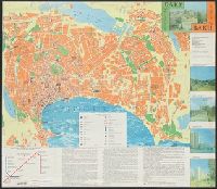
[Gorod Baku = City of Baku] -- [Baku i okrestnosti, Apsheronskiĭ poluostrov = Baku and vicinity, Apsheron Peninsula]., Includes text, 2 island insets, ancillary subway-system map, and col. ill., Panel title., and Russian and English.
Publisher:
Gos. kom-t Azerbaĭdzhanskoĭ Respubliki po geodezii i kartografii,
Subject (Geographic):
Apsheron Peninsula (Azerbaijan)--Maps, Baku (Azerbaijan)--Maps, and Baku Metropolitan Area (Azerbaijan)--Maps
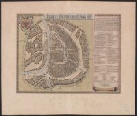
Appears in Blaeu's Atlas major, Fre, Hand col. Sheet measures 54 x 63 cm. Lanman Collection., Russian, Latin and French., Title text in cyrillic; transliteration in Koeman., and Verso: Title "Moskow, ville metropolitaine de Moscovie"; pg. no. 20,b; signature F 2.