Freducci, Conte di Ottomano, active 1497-1539, cartographer
Published / Created:
[1536?]
Call Number:
Covers 49 +1536
Image Count:
6
Resource Type:
cartographic image
Description:
Title devised by cataloger., Pen-and-ink in black, red, blue, green, and gold., Four charts, each measuring 33 x 43 cm, mounted on composite boards and edged with vellum, bound in boards covered by blue cloth with label pasted on front cover (No. [1906/242 in manuscript])., and Inscription on third chart (Mediterranean region from the Strait of Gibraltar to the coast of Greece), "Yhs ma [ver]go Conte freducci de ancona la facta nela[n]no MCCCCCXXXVJ."
Publisher:
Conte di Ottomano Freducci
Subject (Geographic):
Mediterranean Region, North Atlantic Ocean, and Baltic Sea
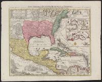
BEIN 85 1740D: Stamp on verso: Yale, Horace Brown, 1900S., BEIN 71 1737A: Forms part of the Benjamin Franklin Collection., Relief shown pictorially., "Cum gratia et privil S.R.I. Vicariatus in partibus Rheni Suevice et Juris Franconici.", Dates inferred from Portobelo inset showing "Admiralis Vernon Bachiam intrans d. 21 Novembr 1739" and reference in Lowery 328 to this map appearing as "... no. 190 in the 'Verlagsübersicht bis 1760', reprinted in Sandler's notice of Seutter.", and Includes insets of Portobelo, Havana, Cartagena, and Veracruz, text, and illustrations.
Publisher:
Tobias Conrad Seutter
Subject (Geographic):
North America, United States, Mexico, Central America, and Caribbean Area
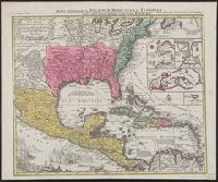
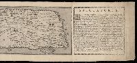
Relief shown pictorially., North oriented down., Bar scale given in unidenified units., Coordinates not present on map and are approximated., Includes index of colleges, buildings, and streets., and Insets: view of Oxforde and a map of Oxfordshire with bar scale in miles.
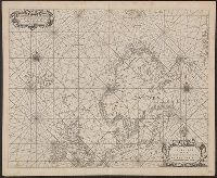
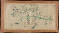
BEIN 21 1670A: Manuscript number on verso: 173. Watermark., Depths shown by isolines and soundings., Coordinates not present on map and are approximated., and From Blaeu's De groote Zee-spiegel (Amsterdam, 1655).
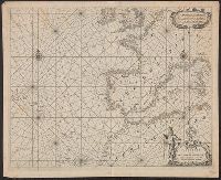
BEIN 21 1670B: Manuscript number on verso: 174. Watermark., Depths shown by isolines and soundings., Coordinates not present on map and are approximated., and From Blaeu's De groote Zee-spiegel (Amsterdam, 1655).
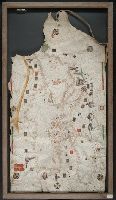
BEIN Art Storage 49cea 1425: Imperfect: lower left corner and bottom edge torn, with some loss of map; slight holes throughout. With leather thone tie on left edge., Portolan chart with seaport names given for all coastlines., Title devised by cataloger., Pen-and-ink in black, red, blue and green., Constantinople shown still in Christian possession; Thrace in possession of the Turks., Contains two compass roses., and Decoration: city views with banners.
Peutinger table and Tabvla itineraria ex illvstri Pevtingerorvm Bibliotheca
Description:
BEIN 2016 +333: Imperfect: title panel mutilated, with some loss of text. Sheets joined together to form a roll; backed in linen., Relief shown pictorially., "MD" in publication date in apostrophic forms., Appears in Ortelius' Theatri Orbis Terrarum Parergon. Antwerp, 1624., and "Peutinger Table: Road map of Western Roman Empire about 250 A.D. bought by Conrad Peutinger and published in Venice by Aldus in 1591 (2 sections only), in Antwerp 1598 (12 sections) ... The only record of Roman map making that has survived to the present day."--Tooley's Dictionary of Mapmakers. New York, 1979.
Title devised by cataloger., "Vinc[enti]us demetrei Volcius Rachuseus. Fecit interra Liiburni die 24 Maius 1601.", With blue cloth tie at left edge., Color: red, blue, and some gold., With four compass roses., and Coordinates not present on map and are approximated.