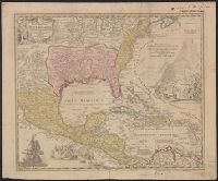
Appears in Homann's Atlas geographicus major ... Normibergae : Curantibus Homannianis heredibus, 1759., Includes notes, ill. of ships in battle, and of Europeans and Native Americans, and four bar scales., Ms. annotations. Ms. no. on verso: 207 III 59. Sheet measures 53.6 x 64.9 cm. Franklin Collection no. 131 1737-2., Relief shown pictorially., Some references suggest earlier possible imprint date., and This edition is at least the second state, as Ludoviciana has replaced Florida as the name of the Louisiana territory.
Publisher:
[Homann Erben?,
Subject (Geographic):
New Spain--Maps--Early works to 1800 and North America--Maps--Early works to 1800
Subject (Name):
Homann Erben (Firm) and Homann, Johann Baptist, 1663-1724. Atlas geographicus major
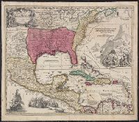
Appears in Homann's Atlas geographicus major ... Normibergae : Curantibus Homannianis heredibus, 1759., Copy 1: Ms. no. on verso: 107. Stamp on verso: Yale, Horace Brown, 1900S. Neat line measures 47.6 x 57.5 on sheet 52 x 62 cm., and Includes notes, ill. of sh
Publisher:
[Homann Erben?,
Subject (Geographic):
New Spain--Maps--Early works to 1800 and North America--Maps--Early works to 1800
Subject (Name):
Homann Erben (Firm) and Homann, Johann Baptist, 1663-1724. Atlas geographicus major
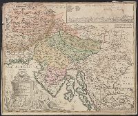
Bar scales given in "milliaria Germanica" and "milliaria Italica.", Insets: map of Cirkhnitzer See and bird's-eye view "Prospekt der St. Laybach ...", Relief shown pictorially., Sheet measures 49.6 x 58.8 cm., and Title in Latin; insets in German.
Publisher:
[Johann Baptist Homann,
Subject (Geographic):
Carniola (Slovenia)--Maps--Early works to 1800 and Croatia--Maps--Early works to 1800
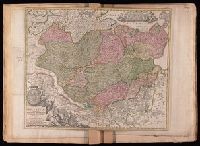
Tabvla generalis Holsatiae complectens Holsatiae, Dithmarsiae, Stormariae, et Vagriae Dvcatvs
Description:
Bar scales given in "milliaria Germanica communia" and "milliaria Gallica sive horae itinerariae"., Includes coat-of-arms and ill., Prime meridian: Ferro., Relief shown pictorially., and Stamps on verso: 144 [crossed out]; 263. Title in ms. on verso. Backed with linen. Sheet measures 48.0 x 57.1 cm. No. 24 of 34 maps bound together.
Publisher:
[Johann Baptist Homann,
Subject (Geographic):
Schleswig-Holstein (Germany)--Maps--Early works to 1800
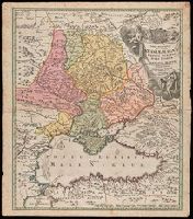
"Cum Privilegio S.C.M.", Bar scales given in wurst seu milliaria Russica, milliaria Polonica, milliaria Germanica, milliaria Gallica., Relief shown by hachures and pictorially., and Watermark. Manuscript number in upper left corner. From the Karpinski-von Wieser Map Collection.
Publisher:
[Johann Baptist Homann]
Subject (Geographic):
Black Sea--Maps--Early works to 1800., Russia--Maps--Early works to 1800., and Ukraine--Maps--Early works to 1800.
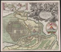
Hand col. Sheet measures 54 x 63 cm. Lada-Mocarski collection., Index to points of interest, and col. illus. of "Crohn Schlot oder Cron Schloss.", and Inset map: "Charte des Neva-Stroms von der Ladogisthen biss in die Ost-See allwo St. Petersburg ... "
Publisher:
Ioh. Baptist Homann,
Subject (Geographic):
Neva River (Russia)--Maps--Early works to 1800 and Saint Petersburg (Russia)--Maps--Early works to 1800
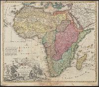
Prime meridian: Tenerife. and Relief shown pictorially.
Publisher:
s.n.,
Subject (Geographic):
Africa--Administrative and political divisions--Maps--Early works to 1800, Africa--Maps--Early works to 1800, and Arabian Peninsula--Maps--Early works to 1800
America occidentalium indiarum nomine Vulgo celebratissima non i[m]merito Europa Nova appellari posset
Description:
2nd state, with California correctly shown as a peninsula., Appears in Homann's Atlas novus., Prime meridian: Teneriffe., Relief shown pictorially., and Sheet measures 50.5 x 62.5 cm. Ms. nos. on verso: 66; 148, America. Franklin Collection 131 1710.