Skip to search
Skip to main content
Skip to first result
Search
You Searched For
Date
Unknown
Extent of Digitization
Unspecified
Format
cartographic
Date Created
[Missing]
New Search
Search Results
Creator:
Published / Created:
1931
Call Number:
766 W73 1931
Image Count:
23
Resource Type:
Maps, Atlases & Globes
Abstract:
Sanborn fire insurance maps are a rich source of historic data on the urban built environment of North America during the 19th and early 20th centuries. The atlases were created for the purpose of underwriting fire insurance policies, which depended upon accurate and frequently-updated information about construction materials, municipal and transportation infrastructure, industrial and commercial landuse and more. The Yale University Library Map Department scanned its holdings of Sanborn fire insurance maps (consisting primarily of Connecticut towns) in order to make the maps more accessible.
Alternative Title:
Jan. 1931, Winsted, Conn. and Winsted, Litchfield County, Connecticut, including Riverton
Description:
"(1087) (23 sheets).", Contains information on population, prevailing winds, water facilities and fire department., Includes index of streets and specials., Partial cadastral map., and SMLMAPL 766 W73 1931: Sheets disbound. "Triplicate" stamp on sheets. Library of Congress copyright stamp on title sheet.
Subject (Geographic):
Winsted (Conn.)--Maps
Subject (Name):
Library of Congress Stamp
Subject (Topic):
Fire risk assessment--Connecticut--Winsted--Maps and Real property--Connecticut--Winsted--Maps
Found in:
Beinecke Rare Book and Manuscript Library > Winsted, Litchfield County, Connecticut.
Call Number:
Zc20 802crc
Collection Title:
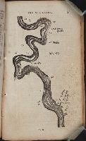
The navigator; or, The traders' useful guide in navigating the Monongahela, Allegheny, Ohio, and
Image Count:
1
Description:
P. 55.
Subject (Geographic):
Chickasaw Bluffs (Tenn.), Mississippi River --Description and travel, Mississippi River --Maps, Mississippi River --Navigation, and Tennessee
Collection Created:
Pittsburgh, From the Press of Zadok Cramer, 1806
Found in:
Beinecke Rare Book and Manuscript Library > [A portion of the Mississippi River, including Chickasaw Bluffs]
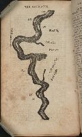
Call Number:
Zc20 802crc
Collection Title:
The navigator; or, The traders' useful guide in navigating the Monongahela, Allegheny, Ohio, and
Image Count:
1
Description:
P. 72.
Subject (Geographic):
Mississippi, Mississippi River --Description and travel, Mississippi River --Maps, Mississippi River --Navigation, and Natchez (Miss.)
Collection Created:
Pittsburgh, From the Press of Zadok Cramer, 1806
Found in:
Beinecke Rare Book and Manuscript Library > [A portion of the Mississippi River, including Natchez]
Creator:
Call Number:
WA MSS S-1590
Collection Title:
Walter Millsap / Keikichi Akana Imamura family papers, 1942-1946
Container / Volume:
Folder 28
Image Count:
1
Subject (Name):
Manzanar War Relocation Center --Pictorial works
Subject (Topic):
Concentration camps --California, Concentration camps --United States, and Japanese Americans--Forced removal and internment, 1942-1945
Found in:
Beinecke Rare Book and Manuscript Library > [Layout of Internment Camp]
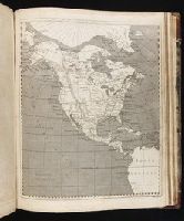
Call Number:
1974 +231
Collection Title:
A new and elegant general atlas, comprising all the new discoveries, to the present time
Image Count:
1
Description:
Map 36 from table of contents.
Subject (Geographic):
North America--Maps
Collection Created:
Philadelphia, J. Conrad & co., Baltimore, M. & J. Conrad & co. [etc., etc.] 1804
Found in:
Beinecke Rare Book and Manuscript Library > [Map of North America]
Creator:
Call Number:
1974 +231
Collection Title:
A new and elegant general atlas, comprising all the new discoveries, to the present time
Image Count:
1
Description:
Map 57 from table of contents.
Subject (Geographic):
Louisiana Purchase--Pictorial works, Louisiana--Maps--1804, and North America--Maps
Collection Created:
Philadelphia, J. Conrad & co., Baltimore, M. & J. Conrad & co. [etc., etc.] 1804
Found in:
Beinecke Rare Book and Manuscript Library > [Map of the Louisiana Territory]
Call Number:
1974 +231
Collection Title:
A new and elegant general atlas, comprising all the new discoveries, to the present time
Image Count:
1
Description:
Map 37 from table of contents.
Subject (Geographic):
North America--Maps and United States--Maps--1804
Collection Created:
Philadelphia, J. Conrad & co., Baltimore, M. & J. Conrad & co. [etc., etc.] 1804
Found in:
Beinecke Rare Book and Manuscript Library > [Map of the United States of America]
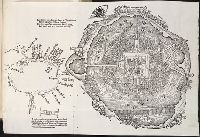
Call Number:
Taylor 58
Collection Title:
Praeclara Ferdinadi. Cortesii de noua maris Oceani Hyspania narratio ... Carolo Romanoru imperatori
Image Count:
1
Description:
Preceding Argumentum Libri. and Teaching resource: Professor John Mack Faragher, History 141: The American West.
Subject (Geographic):
Mexico City (Mexico) and Mexico --History --Conquest, 1519-1540
Subject (Name):
Savorgnano, Pietro
Collection Created:
Norimberga, 1524
Found in:
Beinecke Rare Book and Manuscript Library > [Untitled map of Tenochtitlan]
Branch:v1.61.8 ,Deployed:2024-06-20T11:15:15-04:00