Skip to search
Skip to main content
Skip to first result
Search
You Searched For
Extent of Digitization
Partially digitized
Genre
Engravings
Subject (Topic)
Geography--Early works to 1800
New Search
Search Results
Call Number:
1975 +1
Collection Title:
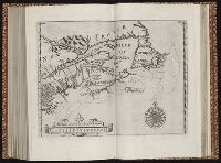
L'isole piv famose del mondo descritte da Thomaso Porcacchi da Castiglione Arretino e intagliate da
Image Count:
1
Resource Type:
Maps, Atlases & Globes
Subject (Geographic):
Hispaniola
Subject (Topic):
Geography--Early works to 1800 and Islands
Collection Created:
Venetia, Appresso gli heredi di S. Galignani, 1604
Found in:
Beinecke Rare Book and Manuscript Library > Descrittione dell'isola Spagnuola
Call Number:
1985 +31
Collection Title:
L'isole piu famose del mondo / descritte da Thomaso Porcacchi da Castiglione Arretino e intagliate
Image Count:
1
Resource Type:
Maps, Atlases & Globes
Subject (Geographic):
Hispaniola
Subject (Topic):
Geography--Early works to 1800
Collection Created:
In Venetia : Appresso Simon Galignani & Girolamo Porro, 1572
Found in:
Beinecke Rare Book and Manuscript Library > Descrittione dell'isola Spagnuola prima iso la scoperta dal Colombo
Call Number:
1985 +31
Collection Title:
L'isole piu famose del mondo / descritte da Thomaso Porcacchi da Castiglione Arretino e intagliate
Image Count:
1
Resource Type:
Books, Journals & Pamphlets
Subject (Topic):
Geography--Early works to 1800
Collection Created:
In Venetia : Appresso Simon Galignani & Girolamo Porro, 1572
Found in:
Beinecke Rare Book and Manuscript Library > L'isole piu famose del mondo
Call Number:
1975 +1
Collection Title:
L'isole piv famose del mondo descritte da Thomaso Porcacchi da Castiglione Arretino e intagliate da
Image Count:
1
Resource Type:
Books, Journals & Pamphlets
Subject (Topic):
Geography--Early works to 1800 and Islands
Collection Created:
Venetia, Appresso gli heredi di S. Galignani, 1604
Found in:
Beinecke Rare Book and Manuscript Library > L'isole piv famose del mondo descritte da Thomaso Porcacchi da Castiglione Arretino e intagliate da Girolamo Porro Padovano con l'aggiunta di molte isole
Call Number:
1974 +188
Collection Title:
L'isole piv famose del mondo descritte da Thomaso Porcacchi da Castiglione Arretino e intagliate da
Image Count:
1
Resource Type:
Books, Journals & Pamphlets
Subject (Topic):
Geography--Early works to 1800 and Islands
Collection Created:
Venetia, Appresso S. Galignani & G. Porro, 1576
Found in:
Beinecke Rare Book and Manuscript Library > L'isole piv famose del mondo descritte da Thomaso Porcacchi da Castiglione Arretino e intagliate da Girolamo Porro, padovano, con l'aggiunta di molte isole
Call Number:
1976 +310
Collection Title:
L'isole piv famose del mondo descritte da Thomaso Porcacchi da Castiglione Arretino e intagliate da
Image Count:
1
Resource Type:
Books, Journals & Pamphlets
Subject (Topic):
Geography--Early works to 1800 and Islands
Collection Created:
Venetia, Appresso S. Galignani & G. Porro, 1576
Found in:
Beinecke Rare Book and Manuscript Library > L'isole piv famose del mondo descritte da Thomaso Porcacchi da Castiglione Arretino e intagliate da Girolamo Porro, padovano, con l'aggiunta di molte isole
Creator:
Published / Created:
1713
Call Number:
1978 Folio 112
Image Count:
1
Resource Type:
Maps, Atlases & Globes
Alternative Title:
Geographie royale
Description:
Title in red and black with vignette.
Publisher:
Chez Pierre vander Aa, marchand libraire,
Subject (Topic):
Atlases, French, Atlases--Early works to 1800, and Geography--Early works to 1800
Found in:
Beinecke Rare Book and Manuscript Library > Le nouveau theatre du monde. ou La geographie royale, composée de nouvelles cartes tres-exactes ... Avec une description geographique et historique des quatre parties de l'univers, desquelles l'Europe en detail est écrite par Mr. Gueudeville, & les trois autres parties par Mr. Ferrarius ...
Creator:
Published / Created:
1739
Call Number:
1996 +91
Image Count:
3
Resource Type:
Books, Journals & Pamphlets
Description:
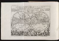
"A continuation ... brought down to the present year 1738 ..." v. 3, p. [649]-784., Frontispiece map, 25 x 41 cm., Imperfect: map opposite p. 425, v.3 wanting., and Map: A plan of Fort St. George and the City of Madras, 25 x 22 cm.
Publisher:
Printed for Messrs. Bettesworth and Hitch; J. Clarke; S. Birt; Tho. Wotton, and J. Shuckburgh; and T. Osborne,
Subject (Geographic):
Madras (India)--Maps--Early works to 1800 and World maps--Early works to 1800
Subject (Name):
Aurangzeb, Emperor of Hindustan, 1618-1707 --Portraits
Subject (Topic):
Geography--Early works to 1800
Found in:
Beinecke Rare Book and Manuscript Library > Modern history: or, The present state of all nations. Describing their respective situations, persons, habits, ... animals and minerals. ... By Mr. Salmon. Illustrated with cuts and maps ... by Herman Moll ...
Published / Created:
1625
Call Number:
Pequot +P978
Collection Title:
Purchas his pilgrimes : In fiue bookes. The first, contayning the voyages and peregrinations made
Image Count:
1
Description:
Bound in following p. 1872.
Subject (Geographic):
America--Discovery and exploration--Early works to 1800
Subject (Topic):
Geography--Early works to 1800, Religions--Early works to 1800, and Voyages and travels--Early works to 1800
Collection Created:
London :
Found in:
Beinecke Rare Book and Manuscript Library > New France
Creator:
Published / Created:
1625
Call Number:
Pequot +P978
Image Count:
1
Alternative Title:
[Hakluytus posthumus] , Hakluytus posthumus or Purchas his pilgrimes., Map of China., New France., and Purchas his pilgrimes in five bookes.
Description:
Accompanied by ALS ([4] p.) to Charles Deane, Cambridge, from Henry Stevens, dated London, Jan. 23, 1875. Uncancelled states of v. 1 G3 and 4M4,5. Vol. 1: [1] Description of East India (27.1 x 35.3 cm, on sheet 33.7 x 38.5 cm) bound in following p. 578; vol. 3: [1] The map of China (27.5 x 34.3 cm, on sheet 33.8 x 37.2 cm) bound in following p. 400; [2] The north part of America (27.4 x 33.3 cm, on sheet 34 x 37.5 cm) bound in following p. 852; vol. 4: [1] Virginia (31.5 x 39.6 cm, on sheet 33.9 x 40 cm, folded to 33.7 x 18.5 cm) bound in following p. 1690; [2] New France (24.9 x 32.7 cm, on sheet 34 x 37.7 cm) bound in following p. 1872.
Publisher:
Printed by William Stansby for Henrie Fetherstone, and are to be sold at his shop in Pauls Church-yard at the signe of the Rose,
Subject (Geographic):
America--Discovery and exploration--Early works to 1800
Subject (Topic):
Geography--Early works to 1800, Religions--Early works to 1800, and Voyages and travels--Early works to 1800
Found in:
Beinecke Rare Book and Manuscript Library > Purchas his pilgrimes : In fiue bookes. The first, contayning the voyages and peregrinations made by ancient kings, patriarkes, apostles, philosophers, and others, to and thorow the remoter parts of the knowne world: enquiries also of languages and religions, especially of the moderne diuersified professions of Christianitie. The second, a description of all the circum-nauigations of the globe. The third, nauigations and voyages of English-men, alongst the coasts of Africa ... The fourth, English voyages beyond the East Indies, to the ilands of Iapan, China, Cauchinchina, the Philippinæ[32]with others ... The fifth, nauigations, voyages, traffiques, discoueries, of the English nation in the easterne parts of the world ... The first part.
Branch:v1.61.8 ,Deployed:2024-06-20T11:15:04-04:00