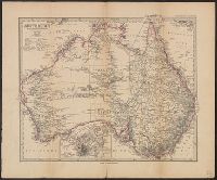
H. Alt & Schröder, engravers Justus Perthes (Firm : Gotha, Germany), publisher Petermann, A. (August Heinrich), 1822-1878 Stieler, Adolf, 1775-1836. Stieler's Hand-Atlas
Published / Created:
[1883?]
Call Number:
26 1883
Container / Volume:
BRBL_00022
Image Count:
1
Resource Type:
Maps, Atlases & Globes
Description:
In German., In lower left margin: Rev. 1883., Map of Australia showing explorers' tracks, railways and telegraph lines. Relief shown by hachures and spot heights., Pr, and Sheet measures 40.5 x 49 cm. Verso: Stamped "Karpinski-von Wieser Map Collection".
Publisher:
Justus Perthes,
Subject (Geographic):
Australia--Discovery and exploration--Maps and Australia--Maps
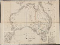
"Stieler's Hand-Atlas No. 72.", Insets: Melbourne und Port Phillip -- Sydney und Port Jackson., Relief shown by hachures., and Stamp: Karpinski-von Wieser Map Collection.
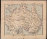
H. Alt & Schröder, engravers Justus Perthes (Firm : Gotha, Germany), publisher Petermann, A. (August Heinrich), 1822-1878 Stieler, Adolf, 1775-1836. Stieler's Hand-Atlas
Published / Created:
[1873?]
Call Number:
26 1873
Container / Volume:
BRBL_00022
Image Count:
1
Resource Type:
Maps, Atlases & Globes
Description:
Imperfect, In German., In lower right margin: Gestochen von H. Alt & Schröder., Map of Australia showing explorers' tracks and railways. Relief shown by hachures and spot heights., and Plate no. 73 from: Stieler's Hand-Atlas. Gotha : J. Perthes, [1873?]
Publisher:
Justus Perthes,
Subject (Geographic):
Australia--Discovery and exploration--Maps and Australia--Maps
"Stieler's Hand-Atlas No. 77.", Insets: Sydney und Port Jackson -- Das südliche Victoria -- Adelaide und Umgebung -- Melbourne und Port Phillip., Mounted on linen. Stamp: Karpinski-von Wieser Map Collection., and Relief shown by hachures.
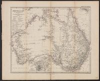
Geographisches Institut (Weimar, Thuringia, Germany) Kiepert, Heinrich, 1818-1899 Weiland, C. F. (Carl Ferdinand), -1847, cartographer
Published / Created:
[1855?]
Call Number:
26 1855
Container / Volume:
BRBL_00022
Image Count:
1
Resource Type:
Maps, Atlases & Globes
Description:
Hand col. Sheet measures 50 x 64.5 cm., In German., Insets: [1.] Neu Süd Wales -- [2.] Colonie Süd-Australia., Prime meridians: Ferro, Greenwich and Paris., and Top right-hand corner: "67".
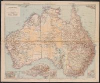
United States. Office of Strategic Services. Research and Analysis Branch
Published / Created:
1944
Call Number:
42gmb 1944
Container / Volume:
BRBL_00245
Image Count:
1
Resource Type:
Maps, Atlases & Globes
Description:
Indicates left- and right- hand driving zones and snow clearing., Map in German; legend and overlays in English., and Relief indicated by spot heights.
Publisher:
Lithographed in the Reproduction Branch, OSS,
Subject (Geographic):
Austria--Maps
Subject (Name):
United States. Office of Strategic Services. Reproduction Branch
Subject (Topic):
Roads--Austria--Maps and Snow removal--Austria--Maps