Skip to search
Skip to main content
Skip to first result
Search
You Searched For
Genre
Maps
Language
German
New Search
Search Results
Creator:
Published / Created:
1940
Call Number:
11hd 1942D-54
Container / Volume:
BRBL_00010ZE
Image Count:
1
Resource Type:
Maps, Atlases & Globes
Alternative Title:
Frankreich and St. Amand
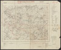
Description:
"Stand 29.3.1940, teilweise 7.4.1940." and Includes legend, list of abbreviations, chart of connecting sheets, and map showing political boundaires.
Publisher:
German General Staff,
Subject (Geographic):
France--Maps
Found in:
Beinecke Rare Book and Manuscript Library > Befestigungskarte Frankreich 1:25000 : St. Amand, Nr. 1-2, XXVI-5/1-2.
Creator:
Published / Created:
1940
Call Number:
11hd 1942D-54
Container / Volume:
BRBL_00010ZE
Image Count:
1
Resource Type:
Maps, Atlases & Globes
Alternative Title:
Frankreich and St. Amand
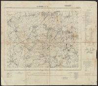
Description:
"Stand 29.3.1940, teilweise 7.4.1940." and Includes legend, list of abbreviations, chart of connecting sheets, and map showing political boundaires.
Publisher:
German General Staff,
Subject (Geographic):
France--Maps
Found in:
Beinecke Rare Book and Manuscript Library > Befestigungskarte Frankreich 1:25000 : St. Amand, Nr. 1-2, XXVI-5/1-2.
Published / Created:
1918-1919.
Call Number:
65 1918
Container / Volume:
BRBL_00341
Image Count:
3
Resource Type:
Maps, Atlases & Globes
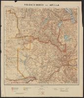
Alternative Title:
Germany. Reichskolonialamt. Mittelafrika in Karten 1:2 000 000.
Description:
Blatt I -- Blatt II -- Blatt III -- Blatt IV.
Publisher:
Dietrich Reimer (Ernst Vohsen),
Subject (Geographic):
Angola--Maps and Congo (Democratic Republic)--Maps
Subject (Name):
Dietrich Reimer Verlag (Berlin, Germany)
Found in:
Beinecke Rare Book and Manuscript Library > Belgisch-Kongo und Angola [cartographic material] : in 4 Blatt.
Creator:
Published / Created:
1582?]
Call Number:
51 1582
Container / Volume:
BRBL_00277
Image Count:
2
Resource Type:
Maps, Atlases & Globes
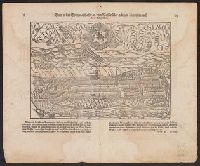
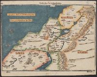
Description:
Appears in Bünting's Itinerarium Sacrae Scripturae., In top margin corners: 26 -- 27., Relief shown pictorially., Signature mark on verso: G., and Text on verso.
Publisher:
J. Lucius,
Subject (Geographic):
Palestine--Maps--Early works to 1800
Subject (Name):
Bünting, Heinrich, 1545-1606. Itinerarium Sacrae Scripturae
Found in:
Beinecke Rare Book and Manuscript Library > Beschreibung des Heiligen Landes.
Published / Created:
Undated
Call Number:
1983 Folio 19
Collection Title:
[Atlas factice of 96 maps by Blaeu, Visscher, Jansson, Hondius and others]
Image Count:
2
Publisher:
Apud Ioannem Ianssonium
Subject (Geographic):
Austria --Maps --Early works to 1800, Czechoslovakia --Maps, Germany --Maps --Early works to 1800, and Poland --Maps --Early works to 1800
Subject (Topic):
Atlases --Early works to 1800
Collection Created:
[1556-1680]
Found in:
Beinecke Rare Book and Manuscript Library > Bohemia
Creator:
Published / Created:
[1725?]
Call Number:
BrSides 2019 67
Image Count:
1
Resource Type:
Maps, Atlases & Globes
Alternative Title:
Bononien
Description:
"Cum privil. sacrae caeser. maiest." and Accompanied by sheet with provenance note, "Gift to Jack in 1954 from Katharine Kosmak ... that once belonged to her father ... Dr. George Kosmak."
Publisher:
[Johann Christian Leopold],
Subject (Geographic):
Bologna (Italy)--Pictorial works--Early works to 1800.
Subject (Name):
Kosmak, George William,--1873---Ownership. and Kosmak, Katharine--Ownership.
Found in:
Beinecke Rare Book and Manuscript Library > Bologna = Bononien / Iohann Christian Leopold excudit, Aug. Vind.
Branch:v1.61.6 ,Deployed:2024-06-12T09:55:19-04:00