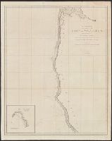
From: Vancouver's A voyage of discovery to the North Pacific Ocean and round the world. London, 1798., In top right margin: 5., Insets: Entrance of Columbia River -- Gray's Harbour -- Port Discovery., and Relief shown pictorially and by hachures. Depths shown by soundings.
Publisher:
J. Edwards & G. Robinson,
Subject (Geographic):
British Columbia--Maps--Early works to 1800 and Washington (State)--Maps--Early works to 1800
Subject (Name):
Arnold, Robert M.--Ownership, Baker, Joseph, 1768-1817, Edwards, James, 1757-1816, Robinson, G. G. (George G.), and Vancouver, George, 1757-1798. Voyage of discovery to the North Pacific Ocean and round the world. 1
Subject (Topic):
Coasts--British Columbia--Maps--Early works to 1800 and Coasts--Washington (State)--Maps--Early works to 1800
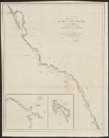
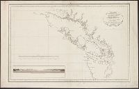
From: Vancouver's A voyage of discovery to the North Pacific Ocean and round the world. London, 1798., In top right margin: 7., Includes inset of "A survey of Port Stewart.", and Relief shown pictorially and by hachures. Depths shown by soundings.
Publisher:
J. Edwards & G. Robinson,
Subject (Geographic):
Alaska--Maps--Early works to 1800 and British Columbia--Maps--Early works to 1800
Subject (Name):
Arnold, Robert M.--Ownership, Baker, Joseph, 1768-1817, Edwards, James, 1757-1816, Robinson, G. G. (George G.), and Vancouver, George, 1757-1798. Voyage of discovery to the North Pacific Ocean and round the world. 1
Subject (Topic):
Coasts--Alaska--Early works to 1800 and Coasts--British Columbia--Maps--Early works to 1800
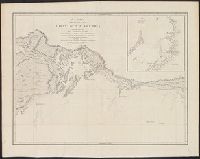
From: Vancouver's A voyage of discovery to the North Pacific Ocean and round the world. London, 1798., In top right margin: Plate 3., Includes inset of "Bay of Trinidad.", and Relief shown pictorially and by hachures. Depths shown by soundings.
Publisher:
J. Edwards & G. Robinson,
Subject (Geographic):
California--Maps--Early works to 1800 and Oregon--Maps--Early works to 1800
Subject (Name):
Arnold, Robert M.--Ownership, Baker, Benjamin, Baker, Joseph, 1768-1817, Edwards, James, 1757-1816, Robinson, G. G. (George G.), and Vancouver, George, 1757-1798. Voyage of discovery to the North Pacific
Subject (Topic):
Coasts--California--Maps--Early works to 1800 and Coasts--Oregon--Maps--Early works to 1800
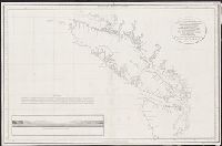
From: Vancouver's A voyage of discovery to the North Pacific Ocean and round the world. London, 1798., In top right margin: 14., and Relief shown pictorially and by hachures.
Publisher:
J. Edwards & G. Robinson,
Subject (Geographic):
Alaska--Maps--Early works to 1800 and Northwest Coast of North America--Maps--Early works to 1800
Subject (Name):
Arnold, Robert M.--Ownership, Edwards, James, 1757-1816, Roberts, Edward, Robinson, G. G. (George G.), and Vancouver, George, 1757-1798. Voyage of discovery to the North Pacific Ocean and round the world. 1798
From: Vancouver's A voyage of discovery to the North Pacific Ocean and round the world. London, 1798., In top right margin: No. 8., Insets: Entrance of Port Sn. Francisco -- Port Sn. Diego., and Relief shown pictorially and by hachures. Depths shown by soundings.
Publisher:
J. Edwards & G. Robinson,
Subject (Geographic):
California--Maps--Early works to 1800
Subject (Name):
Arnold, Robert M.--Ownership, Baker, Joseph, 1768-1817, Edwards, James, 1757-1816, Foot, T. (Thomas), Robinson, G. G. (George G.), and Vancouver, George, 1757-1798. Voyage of discovery to the North Pacifi
From: Vancouver's A voyage of discovery to the North Pacific Ocean and round the world. London, 1798., In top right margin: No. 11., Includes inset of "A survey of Port Chalmers.", and Relief shown pictorially and by hachures. Depths shown by soundings.
Publisher:
J. Edwards & G. Robinson,
Subject (Geographic):
Alaska--Map--Early works to 1800
Subject (Name):
Arnold, Robert M.--Ownership, Baker, Joseph, 1768-1817, Edwards, James, 1757-1816, Foot, T. (Thomas), Robinson, G. G. (George G.), and Vancouver, George, 1757-1798. Voyage of discovery to the North Pacifi
From: Vancouver's A voyage of discovery to the North Pacific Ocean and round the world. London, 1798., Includes inset of "A survey of Port Chatham.", and Relief shown pictorially and by hachures. Depths shown by soundings.
Publisher:
J. Edwards & G. Robinson,
Subject (Geographic):
Alaska--Maps--Early works to 1800
Subject (Name):
Arnold, Robert M.--Ownership, Baker, Joseph, 1768-1817, Edwards, James, 1757-1816, Neele, Samuel John, 1758-1824, Robinson, G. G. (George G.), and Vancouver, George, 1757-1798. Voyage of discovery to the
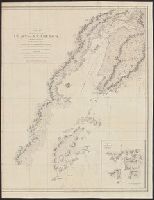
From: Vancouver's A voyage of discovery to the North Pacific Ocean and round the world. London, 1798., In top right margin: No. 12., Insets: Entrance into Cross Sound -- A survey of Port Conclusion -- A survey of Port Protection., and Relief shown pictorially and by hachures.
Publisher:
J. Edwards & G. Robinson,
Subject (Geographic):
Alaska--Maps--Early works to 1800
Subject (Name):
Arnold, Robert M.--Ownership, Baker, Joseph, 1768-1817, Edwards, James, 1757-1816, Foot, T. (Thomas), Robinson, G. G. (George G.), and Vancouver, George, 1757-1798. Voyage of discovery to the North Pacifi
"Juan Moreno Tejada la grabó.", From Atlas marítimo español. 1789-1814., In upper right margin: Numo. Io., Includes text and inset of "Canal de la salida de las goletas, visto al este.", and Shows area around Vancouver Island (B.C.) and Strait of Juan de Fuca.
Publisher:
s.n.,
Subject (Geographic):
Juan de Fuca, Strait of (B.C. and Wash.)--Maps--Early works to 1800, Pacific Coast (B.C.)--Maps--Early works to 1800, Pacific Coast (Wash.)--Maps--Early works to 1800, and Vancouver Island (B.C.)--Maps--Early works to 1800
Subject (Name):
Arnold, Robert M.--Ownership, Moreno Tejada, Juan, Spain. Dirección de Hidrografía. Atlas marítimo español, and Valdés Flores Bazán y Peón, Cayetano, 1767-1835
"Juan Moreno Tejada la grabó.", From Atlas marítimo español. 1789-1814., From the collection of Robert M. Arnold., In upper right margin: Numo. Io., Includes text and inset of "Canal de la salida de las goletas, visto al este.", and Shows a
Publisher:
s.n.,
Subject (Geographic):
Juan de Fuca, Strait of (B.C. and Wash.)--Maps--Early works to 1800, Pacific Coast (B.C.)--Maps--Early works to 1800, Pacific Coast (Wash.)--Maps--Early works to 1800, and Vancouver Island (B.C.)--Maps--Early works to 1800
Subject (Name):
Arnold, Robert M.--Ownership, Moreno Tejada, Juan, Spain. Dirección de Hidrografía. Atlas marítimo español, and Valdés Flores Bazán y Peón, Cayetano, 1767-1835