Skip to search
Skip to main content
Skip to first result
Search
You Searched For
Language
German
Publication Place
Weimar :
New Search
Search Results
Creator:
Published / Created:
1820
Call Number:
70 1820A
Container / Volume:
BRBL_00358
Image Count:
1
Resource Type:
Maps, Atlases & Globes
Description:
Includes inset of Alaska., Library's copy stamped on verso: Yale University Library, Karpinski-Von Wieser Map Collection., and Relief shown by hachures.
Publisher:
Verlage des Geograph Instituts,
Subject (Geographic):
America--Maps
Subject (Name):
Verlage des Geograph Instituts
Found in:
Beinecke Rare Book and Manuscript Library > Charte von America : nach den neuesten Materialien sichersten Ortsbestim̄ungen und der neuesten Eintheilung entworfen / von Friedr. Wilh. Streit, Ober=Lieutnant.
Creator:
Published / Created:
1795
Call Number:
70 1795B
Container / Volume:
BRBL_00357
Image Count:
1
Resource Type:
Maps, Atlases & Globes
Publisher:
im Verlage des Industrie Comptoirs,
Subject (Geographic):
America--Maps--Early works to 1800
Subject (Name):
Ribero, Diego, d. 1533
Found in:
Beinecke Rare Book and Manuscript Library > Charte von Amerika : aus der ältesten noch unedirten Weltcharte des Diego Ribero, Cosmographs Karls V. vom Jahr 1529, ausgehoben und nach dem handschriftlichem Originale in gleicher Grösse gezeichnet / von F.L. Güssefeld.
Creator:
Published / Created:
1804
Call Number:
649 1804
Container / Volume:
BRBL_00340
Image Count:
1
Resource Type:
Maps, Atlases & Globes
Description:
Covers Central Africa from Angola in the south to Mozambique, Zambia, and Congo in the north., In right margin: "An dieses Blatt schliesst sich die Charte von der Kafferkuste.", and Relief shown by hachures.
Publisher:
Im Verlage des Geograph. Instituts,
Subject (Geographic):
Africa, Central--Maps
Found in:
Beinecke Rare Book and Manuscript Library > Charte von Nieder Guinea und den angrenzenden Ländern Sud Afrika's : nach den neuesten und besten Hulfsmitteln / gezeichnet von I.C.M. Reinecke.
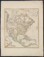
Creator:
Published / Created:
1813
Call Number:
71 1813
Container / Volume:
BRBL_00368
Image Count:
1
Resource Type:
Maps, Atlases & Globes
Alternative Title:
Charte von Nord America
Description:
"Ergänzt und nach den neuern Entdeckungen der Hrn. Lewis Clarke u: Pike vervollstandigt.", Includes inset of "Nordwestlichster Theil von Nord America.", Relief shown by hachures., and Yale's copy stamped on backing: Yale University Library, Karpinski-Von Wieser
Publisher:
im Verlage des Geogr. Instituts,
Subject (Geographic):
North America--Maps
Subject (Name):
Verlage des Geograph Instituts
Found in:
Beinecke Rare Book and Manuscript Library > Charte von NordAmerica / entworfen und gezeichnet von C.G. Reichard.
Creator:
Published / Created:
1817
Call Number:
71 1817
Container / Volume:
BRBL_00368
Image Count:
1
Resource Type:
Maps, Atlases & Globes
Alternative Title:
Charte von Nord America
Description:
Includes inset of "Nordwestlichster Theil von Nord America.", Prime meridian: Paris., and Relief shown by hachures.
Publisher:
im Verlage des Geogr. Instituts,
Subject (Geographic):
North America--Maps
Subject (Name):
Verlage des Geograph Instituts
Found in:
Beinecke Rare Book and Manuscript Library > Charte von NordAmerica / entworfen und gezeichnet von C.G. Reichard.
Creator:
Published / Created:
1802
Call Number:
71 1802B
Container / Volume:
BRBL_00367
Image Count:
1
Resource Type:
Maps, Atlases & Globes
Description:
Colors used to represent United States and colonial possessions of England, Germany, Spain, France, Holland, Denmark and Sweden., Has watermarks., Prime meridian: Paris., and Relief shown by hachures.
Publisher:
Verlage des Industrie Comptoirs,
Subject (Geographic):
Caribbean Area--Maps and North America--Maps
Subject (Name):
Verlag des Industrie Comptoirs
Found in:
Beinecke Rare Book and Manuscript Library > Charte von Nordamerica : nach den neuesten Bestimmungen und Entdeckungen / von C.G. Reichard.
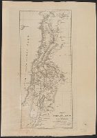
Published / Created:
1828
Call Number:
507 1828
Container / Volume:
BRBL_00277
Image Count:
1
Resource Type:
Maps, Atlases & Globes
Description:
Preliminary record.
Publisher:
Geograph Instituts.,
Subject (Geographic):
Syria--Maps
Found in:
Beinecke Rare Book and Manuscript Library > Charte von Syrien und Palaestina.
Published / Created:
1817
Call Number:
40 1817
Container / Volume:
BRBL_00199
Image Count:
1
Resource Type:
Maps, Atlases & Globes
Publisher:
Im Verlage des geograph. Instituts,
Subject (Geographic):
Italy, Southern--Maps and Naples (Kingdom)--Maps
Found in:
Beinecke Rare Book and Manuscript Library > Charte von Unter-Italien oder dem Königreich Neapel.
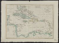
Published / Created:
1814
Call Number:
85 1814
Container / Volume:
BRBL_00638
Image Count:
1
Resource Type:
Maps, Atlases & Globes
Description:
Borders are hand colored according to European possession., Includes three bar scales., Prime meridians: Ferro and London., and Relief shown by hachures.
Publisher:
Im Verlage des Geograph. Instituts,
Subject (Geographic):
West Indies--Maps
Subject (Name):
Geographisches Institut (Weimar, Thuringia, Germany)
Found in:
Beinecke Rare Book and Manuscript Library > Charte von West Indien oder den Antillischen Inseln.
Creator:
Published / Created:
1801
Call Number:
634 Z17 1801
Container / Volume:
BRBL_00336
Image Count:
1
Resource Type:
Maps, Atlases & Globes
Description:
In lower left margin: 86. and Relief shown by hachures.
Publisher:
Verlag des Industrie Comptoins,
Subject (Geographic):
Madagascar--Maps
Subject (Topic):
Coasts--Mozambique--Maps and Coasts--Tanzania--Maps
Found in:
Beinecke Rare Book and Manuscript Library > Charte von Zanguebar der Kafferküste und der Insel Madagascar : nach den neuesten und besten Hülfsmitteln / gezeichnet von I.C.M. Reinecke.
Branch:v1.64.0 ,Deployed:2024-09-11T10:25:35-04:00