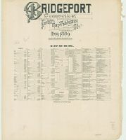
Sanborn fire insurance maps are a rich source of historic data on the urban built environment of North America during the 19th and early 20th centuries. The atlases were created for the purpose of underwriting fire insurance policies, which depended upon accurate and frequently-updated information about construction materials, municipal and transportation infrastructure, industrial and commercial landuse and more. The Yale University Library Map Department scanned its holdings of Sanborn fire insurance maps (consisting primarily of Connecticut towns) in order to make the maps more accessible.
Alternative Title:
Bridgeport, Conn.
Description:
Contains information on population, prevailing winds, water facilities and fire department., Includes index of streets and specials., Partial cadastral map., SMLMAPL 766 B76 1889: Imperfect: sheets chipped at edges, with no loss of text. Sheets disbound. "Triplicate" stamp on all sheets. Library of Congress copyright stamp on index sheet., and The unnumbered leaf is the title and index sheet.
Subject (Geographic):
Bridgeport (Conn.)--Maps
Subject (Name):
Library of Congress Stamp
Subject (Topic):
Fire risk assessment--Connecticut--Bridgeport--Maps and Real property--Connecticut--Bridgeport--Maps
Fire insurance map, colored to show building construction, property boundaries and house and block numbers.
Alternative Title:
Aug. 1923, Bridgeville, Del. and Bridgeville, Del.
Description:
Coordinates not present on map and are approximated., Sheet 1 includes key to building colors and other features of construction, water facilities and fire department, index map for the adjoining sheets, and information about updates., Stamps below title: 427,0, Oct. 22, 1923., and Title from sheet 1.
Publisher:
Sanborn Map Company,
Subject (Geographic):
Bridgeville (Del.)--Maps.
Subject (Topic):
Fire risk assessment--Delaware--Bridgeville--Maps. and Real property--Delaware--Bridgeville--Maps.
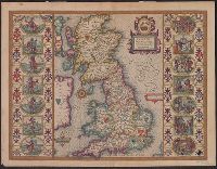
Brightstovve, vulgo; quondam venta, floretissimum Angliae Emporium and Civitates orbis terrarum.
Description:
Mounted on sheet. Annotation on sheet: "Hoefnagel's map of Bristol, 1581 (Braun's Civitates). It shows Broad Stt., where the tennis court stood (1636). Preliminary record.
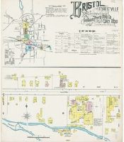
Sanborn fire insurance maps are a rich source of historic data on the urban built environment of North America during the 19th and early 20th centuries. The atlases were created for the purpose of underwriting fire insurance policies, which depended upon accurate and frequently-updated information about construction materials, municipal and transportation infrastructure, industrial and commercial landuse and more. The Yale University Library Map Department scanned its holdings of Sanborn fire insurance maps (consisting primarily of Connecticut towns) in order to make the maps more accessible.
Alternative Title:
May 1890, Bristol, Conn.
Description:
"(3776) 9 sheets.", Contains information on population, prevailing winds, water facilities and fire department., Includes index of streets and specials., Partial cadastral map., and SMLMAPL 766 B77 1890: Sheets disbound. "Triplicate" stamp on all sheets. Library of Congress copyright stamp on title sheet.
Subject (Geographic):
Bristol (Conn.)--Maps
Subject (Name):
Library of Congress Stamp
Subject (Topic):
Fire risk assessment--Connecticut--Bristol--Maps and Real property--Connecticut--Bristol--Maps
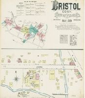
Sanborn fire insurance maps are a rich source of historic data on the urban built environment of North America during the 19th and early 20th centuries. The atlases were created for the purpose of underwriting fire insurance policies, which depended upon accurate and frequently-updated information about construction materials, municipal and transportation infrastructure, industrial and commercial landuse and more. The Yale University Library Map Department scanned its holdings of Sanborn fire insurance maps (consisting primarily of Connecticut towns) in order to make the maps more accessible.
Alternative Title:
May 1884, Bristol, Conn.
Description:
"5 sheets.", Contains information on population, prevailing winds, water facilities and fire department., Includes index of specials., Partial cadastral map., and SMLMAPL 766 B77 1884: Sheets disbound. "Triplicate" stamp on all sheets. Library of Congress copyright stamp on title sheet.
Subject (Geographic):
Bristol (Conn.)--Maps
Subject (Name):
Library of Congress Stamp
Subject (Topic):
Fire risk assessment--Connecticut--Bristol--Maps and Real property--Connecticut--Bristol--Maps
From Speed's The theatre of the empire of Great Britaine., Hand col. Sheet measures 42 x 55 cm. Lanman Collection., Left and right borders contain illustrations of notable persons from each of the 14 political districts., and Running title on verso: Heptarchiae
Publisher:
Are to be sold by John Sudbury & Georg. Humble,
Subject (Geographic):
Great Britain--Maps--Early works to 1800
Subject (Name):
Humble, George, d. 1640, Speed, John, 1552?-1629. Theatre of the Empire of Great Britaine, and Sudbury, John
Appears in William Camden's Camden's Britannia (1695)., Imprint derived from the earliest atlas in which the map was issued., London meridian., Relief shown pictorially., Shows Roman placenames., and Subsequently issued in the same state in several editions of the
Publisher:
[A. Swalle & A. & J. Churchill],
Subject (Geographic):
British Isles--Early works to 1800--Maps, Europe--British Isles, and Great Britain
Subject (Name):
Camden, William, 1551-1623. Britannia. English and Morden, Robert, approximately 1650-1703