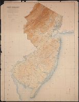
Includes population chart and index to ownership of electric railways., Inset: Map showing the lines of communication between New York, Boston and the West., and Relief shown by shading and spot heights.
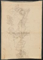
Preliminary agricultural map of Colville region, Washington Terr., Preliminary agricultural map of Yakima Region., and Soils of the Yakima and Colville regions.
Description:
Accompanied by text: Soils of the Yakima and Colville regions (1 leaf ; 61 cm.), Cover title., Preliminary agricultural map of Yakima Region -- Preliminary agricultural map of Colville region, Washington Terr., Raphael Pumpelly, director., and Relief shown by contours, spot heights, and hachures.
Publisher:
Julius Bien & Co.,
Subject (Name):
Hilgard, Eugene W. (Eugene Woldemar), 1833-1916, Julius Bien & Co, and Pumpelly, Raphael, 1837-1923
In upper left margin: Eleventh Census of the United States., Includes text and table of railroads' statutory authorizations., Prime meridians: Washington and Greenwich., and Relief indicated by hachures.
In bottom margin: Photolithographed preliminary sheet for the use of the parties in the field and subject to revision., In top margin: Northe, Library's copy separated into two sheets (59 x 58 cm. and 59 x 55 cm.)., and Relief shown by contours and spot heights.
Publisher:
Northern Transcontinental Survey?],
Subject (Geographic):
Judith River Watershed (Mont.)--Maps, Topographic
Subject (Name):
Julius Bien & Co, Northern Transcontinental Survey. Topographical Dept, and Owen, F. D
Relief shown by spot heights. and Shows roads, railroads, settlements, original patents, towns, Onondaga Indian Reservation, etc.
Publisher:
Julius Bien & Co.,
Subject (Geographic):
Cayuga County (N.Y.)--Maps, Onondaga County (N.Y.)--Maps, and Oswego County (N.Y.)--Maps
Subject (Name):
Bien, Joseph R. Atlas of the state of New York, New York : Julius Bien & Co., 1895. pl. 27 and Julius Bien & Co
Subject (Topic):
Land grants--New York (State)--Cayuga County--Maps, Land grants--New York (State)--Onondaga County--Maps, and Land grants--New York (State)--Oswego County--Maps
"Engraved Apr. 1901 by Julius Bien & Co.", "Surveyed, Plate CXLI from the "Twenty-first annual report" of the U.S. Geological Survey, Part 5, Forest reserves (1900)., Relief shown by contours and spot heights., and Shows four classes of land cover.
Publisher:
The Survey,
Subject (Geographic):
Black Hills National Forest (S.D. and Wyo.)--Maps and Weston County (Wyo.)--Maps
Subject (Name):
Geological Survey (U.S.). Annual report and Julius Bien & Co
Subject (Topic):
Forests and forestry--Wyoming--Weston County--Maps and Land capability for agriculture--Wyoming--Weston County--Maps
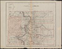
"Department of the Interior, General Land Office, J.S. Williamson, Commissioner.", "Photo lith and print by Julius Bien, 16 and 18 Park Place, N.Y.", and Relief shown by hachures.
Publisher:
J. Bien,
Subject (Geographic):
Colorado--Maps
Subject (Name):
Julius Bien & Co and United States. General Land Office
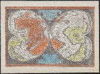
"Ne que ad nos Fram orbis ... Cappadocie 7.", "Quam hic vides orbis imagine lector cadide ... Vale 1538", Cordiform map of the world, 1538, Joanni Drosio suo Gerardus Rupelmudan deducabat., Map of the world, 1538, Orbis imago., and World map on double cordiform pro
Description:
Also known as World map on double cordiform projection and Orbis imago., Cross collection no. 4., Facsimile of Gerhard Mercator's first world map, published in Louvain, 1538., Relief shown pictorially., and Title from another facsimile published by the New York Public Library.
Publisher:
Julius Bien & Co., photo-lith,
Subject (Name):
Brevoort, James Carson, 1818-1887 and Julius Bien & Co
Subject (Topic):
Early maps--Facsimiles and World maps--Early works to 1800--Facsimiles
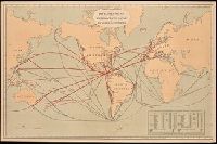
Includes "Table showing distances in miles between commercial ports of the world and distances saved by the Nicaragua Canal." and Shows "present routes" in black and "new routes via Nicaragua canal" in red.
Publisher:
Julius Bein & Co., Photo. Lith.,
Subject (Geographic):
Nicaragua Canal (Nicaragua)--Maps. and Nicaragua--Nicaragua Canal
"Copyright 1895, Julius Bien & Company N.Y.", From: Atlas of the state of New York. New York : Julius Bien & Co., 1895., Maps prepared by Joseph Bien., Relief shown by spot heights., and Shows roads, railroads, settlements, original patents, towns, Oil Spring Res
Publisher:
Julius Bien & Co.,
Subject (Geographic):
Allegany County (N.Y.)--Maps and Steuben County (N.Y.)--Maps
Subject (Name):
Bien, Joseph R. Atlas of the state of New York and Julius Bien & Co
Subject (Topic):
Land grants--New York (State)--Allegany County--Maps and Land grants--New York (State)--Steuben County--Maps
Lake Itasca basin, Minnesota, within Itasca State Park
Description:
" ... Topography by W.G. Comber, G.H. French and F.G. Ray. Hydrography by W.G. Comber. Office reduction, under the direction of C.W. Clark ... by A.T. Morrow, W.G. Comber, G.H. French, E.L. Harman, W.S. Williams, F.G. Ray, and Geo. H. Wolbrecht. Drawing,
Publisher:
s.n.,
Subject (Geographic):
Itasca State Park (Minn.)--Maps and Itasca, Lake (Minn.)--Maps
Subject (Name):
Clark, C. W, Comber, W. G, D'Ailly, H. A. H, French, G. H, Harmon, E. L, Julius Bien & Co, Morrow, A. T, Ray, F. G, Widen, K. A, and Williams, W. S
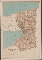
From: Atlas of the state of New York. New York : Julius Bien & Co., 1895., Maps prepared by Joseph, Relief shown by spot heights., and Shows roads, railroads, settlements, original patents, towns, Allegany Indian Reservation, Cattaraugus Indian Reservation, etc.
Publisher:
Julius Bien & Co.,
Subject (Geographic):
Cattaraugus County (N.Y.)--Maps and Chautauqua County (N.Y.)--Maps
Subject (Name):
Bien, Joseph R. Atlas of the state of New York and Julius Bien & Co
Subject (Topic):
Land grants--New York (State)--Cattaraugus County--Maps and Land grants--New York (State)--Chautauqua County--Maps
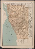
"Copyright 1895, Julius Bien & Company N.Y.", From: Atlas of the state of New York. New York : Julius Bien & Co., 1895., Maps prepared by Joseph Bien., and Shows streets, railroads, wards, parks, major buildings, lighthouses, etc.
Publisher:
Julius Bien & Co.,
Subject (Geographic):
Buffalo (N.Y.)--Maps
Subject (Name):
Bien, Joseph R. Atlas of the state of New York and Julius Bien & Co
"Julius Bien & Co. Lith. N.Y.", "Surveyed in 1899.", Plate CXXXVIII from the "Twenty-first annual report" of the U.S. Geological Survey, Part 5, Forest reserves (1900)., Relief shown by contours and spot heights., and Shows six classes of land cover.
Publisher:
The Survey,
Subject (Geographic):
Bighorn National Forest (Wyo.)--Maps and Sheridan County (Wyo.)--Maps
Subject (Name):
Geological Survey (U.S.). Annual report, Julius Bien & Co, and Tweedy, Frank, 1854-1937
Subject (Topic):
Forests and forestry--Wyoming--Sheridan County--Maps and Land capability for agriculture--Wyoming--Sheridan County--Maps
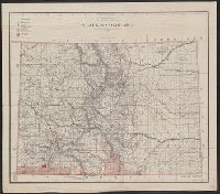
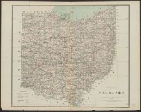
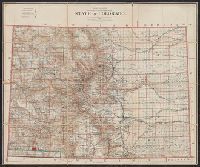
Prime meridians: Greenwich and Washington., Relief shown by shading., and Shows drainage, counties, railroads, private land grants, township lines, etc.
Publisher:
General Land Office?],
Subject (Geographic):
Colorado--Maps
Subject (Name):
Julius Bien & Co, Naylor, Wm, and United States. General Land Office
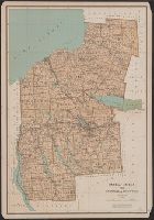
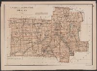
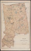
From: Atlas of the state of New York. New York : Julius Bien & Co., 1895., Relief shown by spot heights., and Show roads, railroads, settlements, original patents, towns, etc.
Publisher:
Julius Bien & Co.,
Subject (Geographic):
Livingston County (N.Y.)--Maps and Wyoming County (N.Y.)--Maps
Subject (Name):
Bien, Joseph R. Atlas of the state of New York and Julius Bien & Co
Subject (Topic):
Land grants--New York (State)--Livingston County--Maps and Land grants--New York (State)--Wyoming County--Maps
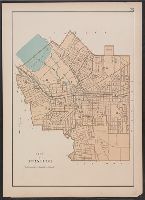
From: Atlas of the state of New York. New York : Julius Bien & Co., 1895. and Shows streets, railroads, canals, wards, parks, cemeteries, major buildings, etc.
Publisher:
Julius Bien & Co.,
Subject (Geographic):
Syracuse (N.Y.)--Maps
Subject (Name):
Bien, Joseph R. Atlas of the state of New York and Julius Bien & Co
From: Atlas of the state of New York. New York : Julius Bien & Co., 1895., Relief shown by spot heights., and Show roads, railroads, settlements, original patents, towns, etc.
Publisher:
Julius Bien & Co.,
Subject (Geographic):
Genesee County (N.Y.)--Maps, Monroe County (N.Y.)--Maps, and Orleans County (N.Y.)--Maps
Subject (Name):
Bien, Joseph R. Atlas of the state of New York and Julius Bien & Co
Subject (Topic):
Land grants--New York (State)--Genesee County--Maps, Land grants--New York (State)--Monroe County--Maps, and Land grants--New York (State)--Orleans County--Maps
"Copyright 1895, Julius Bien & Company N.Y.", From: Atlas of the state of New York. New York : Juli, Maps prepared by Joseph Bien., and Shows roads, railroads, settlements, Tonawanda Indian Reservation, Tuscarora Indian Reservation, original patents, towns, etc.
Publisher:
Julius Bien & Co.,
Subject (Geographic):
Erie County (N.Y.)--Maps and Niagara County (N.Y.)--Maps
Subject (Name):
Bien, Joseph R. Atlas of the state of New York and Julius Bien & Co
Subject (Topic):
Land grants--New York (State)--Erie County--Maps and Land grants--New York (State)--Niagara County--Maps
From: Atlas of the state of New York. New York : Julius Bien & Co., 1895., Relief shown by hachures., and Shows streets, railroads, canal, wards, parks, major buildings, etc.
Publisher:
Julius Bien & Co.,
Subject (Geographic):
Rochester (N.Y.)--Maps
Subject (Name):
Bien, Joseph R. Atlas of the state of New York and Julius Bien & Co
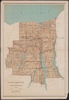
Relief shown by spot heights. and Shows roads, railroads, settlements, original patents, towns, etc.
Publisher:
Julius Bien & Co.,
Subject (Geographic):
Ontario County (N.Y.)--Maps, Seneca County (N.Y.)--Maps, Wayne County (N.Y.)--Maps, and Yates County (N.Y.)--Maps
Subject (Name):
Bien, Joseph R. Atlas of the state of New York, New York : Julius Bien & Co., 1895. pl. 29 and Julius Bien & Co
Subject (Topic):
Land grants--New York (State)--Ontario County--Maps, Land grants--New York (State)--Seneca County--Maps, Land grants--New York (State)--Wayne County--Maps, and Land grants--New York (State)--Yates County--Maps
Bird's-eye view of the interoceanic canal of Nicaragua and Costa Rica, Harvard Map Collection digital maps. Nicaragua. Nicaragua Canal., and Interoceanic canal of Nicaragua and Costa Rica
Description:
"Compliments of the Canal Company" printed in lower left margin. and Imperfect. Chipped with some loss of text.
Publisher:
Julius Bien & Co.,
Subject (Geographic):
Nicaragua Canal (Nicaragua)--Pictorial works and Nicaragua Lake (Nicaragua)--Pictorial works
Subject (Name):
Julius Bien & Co and Nicaragua Canal Construction Company
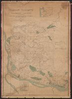
"Copyright 1895, Julius Bien & Company N.Y.", From: Atlas of the state of New York. New York : Julius Bien & Co., 1895., Maps prepared by Joseph Bien., Relief shown by hachures and spot heights., and Shows roads, railroads, settlements, original patents, towns, e
Publisher:
Julius Bien & Co.,
Subject (Geographic):
Hamilton County (N.Y.)--Maps and Herkimer County (N.Y.)--Maps
Subject (Name):
Bien, Joseph R. Atlas of the state of New York and Julius Bien & Co
Subject (Topic):
Land grants--New York (State)--Hamilton County--Maps and Land grants--New York (State)--Herkimer County--Maps
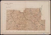
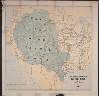
"No I.", "To accompany a report in reply to a resolution of the House of Representatives dated Feb 16th, 1885"., and Shows cattle trails, quarantine lines, "assumed northern limit of Texas fever district", railroads, cities and towns, Indian reservations, rivers, and isotherms.
Publisher:
Julius Bien & Co.,
Subject (Name):
Julius Bien & Co, Nimmo, Joseph, 1837-1909, and United States. Dept. of the Treasury. Report on the internal commerce of the United States
Subject (Topic):
Railroads--West (U.S.)--Maps and Rangelands--West (U.S.)--Maps
Geological and Geographical Survey of the Territories (U.S.)
Published / Created:
1879
Call Number:
80cbj 1879
Container / Volume:
BRBL_00537
Image Count:
1
Resource Type:
Maps, Atlases & Globes
Description:
Relief shown by hachures and spot heights.
Publisher:
the Survey,
Subject (Geographic):
Green River Watershed (Wyo.-Utah)--Maps
Subject (Name):
Bechler, G. R, Chittenden, George B, Clark, Fred A, Gannett, Henry, 1846-1914, Hayden, F. V. (Ferdinand Vandeveer), 1829-1887, Julius Bien & Co, and Wilson, A. D. (Allen D.)
Subject (Topic):
Watersheds--Idaho--Maps, Watersheds--Utah--Maps, and Watersheds--Wyoming--Maps
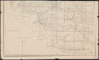
City of Vancouver., Map of Clark County, Washington Territory :, and Vancouver, Klickitat & Yakima R.R. and its proposed connections.
Description:
"Entered according to act of Congress A.D. 1888 by the Auditor of Clarke County W.T. in the office of the clerk of the U.S. district court for the district of Washington Territory, and a copy filed with the Librarian of Congress." and In bottom margin: Julius Bien & Co. photo-lith.
Publisher:
s.n.],
Subject (Geographic):
Clark County (Wash.)--Maps
Subject (Name):
Julius Bien & Co
Subject (Topic):
Real property--Washington (State)--Clark County--Maps
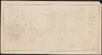
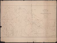
In bottom margin: Photolithographed preliminary sheet for the use of the parties in the field and subject to revision., In top margin: Souther, Library's copy separated into two sheets (76 x 43 cm. and 76 x 59 cm.), and Relief shown by contours and spot heights.
Publisher:
Northern Transcontinental Survey?],
Subject (Geographic):
Judith River Watershed (Mont.)--Maps, Topographic
Subject (Name):
Julius Bien & Co and Northern Transcontinental Survey. Topographical Dept
"Photolithographed preliminary sheet for the use of the parties in the field and subject to revision.", Library's copy has separated into 2 sheets (each 82 x 60 cm.), at center fold., and Relief shown by contours and spot heights.
Publisher:
Northern Transcontinental Survey?],
Subject (Geographic):
Crazy Mountains Region (Mont.)--Maps, Topographic
Subject (Name):
Julius Bien & Co and Northern Transcontinental Survey. Topographical Dept
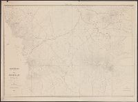
Map of Yakima Region, Washington Ter., western sheet
Description:
"Photolithographed preliminary sheet for the use of the parties in the field, and subject to revision.", In top margin: Western sheet., and Relief shown by contours and spot heights.
Publisher:
Northern Transcontinental Survey?],
Subject (Geographic):
Yakima River Valley (Wash.)--Maps, Topographic
Subject (Name):
Goode, Richard Urquhart, 1858-1903, Julius Bien & Co, Northern Transcontinental Survey, Owen, F. D, and Tweedy, Frank, 1854-1937
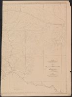
Map of Yakima Region, Washington Ter., eastern sheet
Description:
"Photolithographed preliminary sheet for the use of the parties in the field, and subject to revision.", "There is a slight discordance in projecting the U.S. Land Survey upon this map. A part of the S.W. corner is taken from the U.S. Land Office plats.", and n top margin: Eastern sheet.
Publisher:
Northern Transcontinental Survey?],
Subject (Geographic):
Yakima River Valley (Wash.)--Maps, Topographic
Subject (Name):
Goode, Richard Urquhart, 1858-1903, Julius Bien & Co, Northern Transcontinental Survey, Owen, F. D, and Tweedy, Frank, 1854-1937
no. 1. Yorktown to Williamsburg -- no. 2. Williamsburg to White House -- no. 3. White House to Harrison's Landing., Relief shown by hachures., and Yale copy: each sheet comprises 4 sections, mounted on linen. "Photographed at the Coast Survey office." Shows no
Publisher:
Corps of Engineers?]
Subject (Geographic):
Virginia Peninsula (Va.)--Maps
Subject (Name):
Dougal, William H., 1822-1895, Humphreys, A. A. (Andrew Atkinson), 1810-1883, Julius Bien & Co, United States Coast Survey., and United States. Army of the Potomac
Subject (Topic):
Peninsular Campaign, 1862--Maps and Williamsburg, Battle of, Williamsburg, Va., 1862--Maps
"Photolithographed copy of Gerard Mercator's Mapamundi of 1538 from an original engraving in the library of the American Geographical Society.", Relief shown pictorially., and Title devised by cataloger.
Publisher:
Julius Bien & Co., photo-lith,
Subject (Geographic):
World--Maps--Early works to 1800
Subject (Name):
American Geographical Society of New York and Julius Bien & Co
Subject (Topic):
Early maps, Early maps--Facsimiles, World maps, and World maps--Early works to 1800